Fire lookout · Talladega County, Alabama
Horn Mountain Fire Lookout Tower
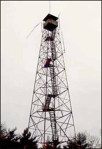
CCC-era 100-foot International Derrick tower on Talladega National Forest land; build year disputed (1936 vs 1938); NHLR-registered 2009; no current condition or access rule found.
- Status unknown
- Open to the public
- Verified
Status unknown: We do not know yet whether it still stands. NHLR-registered 2009, but no later condition record found; the only hint of present-day standing is an undated Pinhoti Trail listing in the present tense
Visit & stay
Not rentable. As far as we know, this lookout cannot be booked for overnight stays.
Access
Open to the public. On Talladega National Forest land beside the Pinhoti Trail; sources do not say whether the cab is open; climbing not advised
- Can you climb it?
- Unknown
- Road to the top?
- Unknown
- Trail
- Along the Pinhoti Trail section from Bull's Gap to Porter's Gap, listed as 18 miles long
- Staffing
- Unknown
Facts
- Status
- sources disagree
- Type
- Cab on a tower100-foot International Derrick tower with 7 by 7 foot cabThe design: IDECO
- Built of
- SteelGoing by its design; no source says so in words.
- Built
- 1936
- Height
- 100 ft (30.5 m)
- Elevation
- 1,918 ft (585 m)
- Agency
- U.S. Forest Service
- Land
- Federal land
- Location
- Talladega County, Alabama
- Coordinates
- 33.29778, −86.07444
- Registers
- This entry
- VerifiedResearched, then checked independently. Updated 8 Oct 2026.
- Firefinder id
us-al-horn-mountain
View from the cab
What you see from the cab: every ridge out to about 93 miles, the named peaks in sight, and other fire lookouts within view, worked out from terrain data in your browser.
Downloads about 2.9 MB of terrain data the first time.
Or see what it could see on the map: the ground in its line of sight.
History
Then and now
- 1936 BuiltRegister's build year; Forest Lookouts gives 1938 (see resolved_conflicts)Source: nhlr.org
- No record between 1936 and 2009
- 2009 Added to the National Historic Lookout RegisterRegistered January 15, 2009 as US 760, AL 7; nominated by Thomas KaufmannSource: nhlr.org
- 2014 EventForest Service decision signed for a new telecommunications tower at the existing Horn Mountain communications site; the record does not mention the fire towerSource: fs.usda.gov
- TodayStatus unknownWe do not know whether it still stands.
Old maps of this spot
USGS topographic maps from the years a lookout stood may show it, often as a small symbol labelled “Lookout”. See the old topo maps around it on the Firefinder map, or find every scanned sheet of this spot on USGS TopoView (opens another site) (click the spot there to list them, with dates and downloads).
Story
Researched 9 Oct 2026, fact-checked.
The Register places the Horn Mountain Fire Lookout Tower in the Talladega National Forest, in Talladega County.1 It says the Civilian Conservation Corps built the Skyway Motor Way along the forest's crest in the 1930s and also put up the fire tower on one of the highest points.1 It describes a 100-foot International Derrick tower with a 7-by-7-foot cab.1
The sources disagree on the date. The Register says the tower was built in 1936,1 while the Forest Lookouts page dates the steel tower to 1938, when members of the Civilian Conservation Corps erected it.2 The sources read do not settle which is right.
No staffing history, notable fires or keeper names turned up in the sources read.
A Forest Service project record for a new telecommunications tower at the existing Horn Mountain communications site shows its decision signed on December 5, 2014.3 That record does not mention the fire tower, so it does not say what became of it.3
A Pinhoti Trail listing says the Horn Mountain Fire Tower lies along a hike on the spine of Horn Mountain, and gives that trail section a length of 18 miles.4 The listing is undated and uses the present tense, so it is the only source read that hints the tower still stands.
Thomas Kaufmann's column on Alabama's towers in general reports that many survivors are unsafe and that climbing them is illegal, and that the state holds on to roughly a third of its former lookouts.5 Visitors should not climb this tower. The sources read do not say whether the cab is open or what the access rules are on the forest land.
- Horn Mountain Fire Lookout Tower, National Historic Lookout Register (nhlr.org), http://nhlr.org/lookouts/us/al/horn-mountain-fire-lookout-tower/ (accessed 2026-10-09). ↩
- Horn Mountain, Forest Lookouts (easternuslookouts.weebly.com), https://easternuslookouts.weebly.com/horn-mountain.html (accessed 2026-10-09). ↩
- Horn Mountain Communication Tower, U.S. Forest Service, https://www.fs.usda.gov/r08/alabama/projects/42473 (accessed 2026-10-09). ↩
- Pinhoti Trail, Bull's Gap Trailhead to Porter's Gap Trailhead, Alabama Recreation Trails, https://alabamarecreationtrails.org/trail/bulls-gap-trailhead-to-porters-gap-trailhead-2 (accessed 2026-10-09). ↩
- Thomas Kaufmann, "Keeping Alabama's historic lookout towers," 1819 News, https://1819news.com/news/item/thomas-kaufmann-keeping-alabamas-historic-lookout-towers (accessed 2026-10-09). ↩
Photos
Photos keep their own rights and are shown with credit. Is one of these yours? You can ask for a different credit or for removal.
Where sources disagree
We show disagreements between sources instead of quietly picking one. If you know which is right, please tell us.
Sources disagree on whether it still stands.
- Firefinder research: Status unknown
- NHLR: Standing
Research (2026-10-09) gives unknown where the source records give standing. The page shows the researched status; please tell us if it is wrong.
Sources
- National Historic Lookout Register (NHLR) (opens another site) Gave us: name, location, county, elevation, type, what it is built of, status, register numbers, agency, ownership, dates, photos, links National Historic Lookout Register (nhlr.org) · All rights reserved (American Resources, Inc.); facts extracted only, no prose copied. · retrieved 4 Oct 2026
- FOREST LOOKOUTS -- eastern US (easternuslookouts.weebly.com) (opens another site) Gave us: links easternuslookouts.weebly.com · No licence stated; facts only (county, coordinates where the page's own map widget gives them, status, height, design hints, register links). The site's own historical quotes, newspaper citations and narrative are not reproduced. · retrieved 8 Oct 2026
- Firefinder research Gave us: summary, design, height, status, agency, access, visiting details, dates, links, fact-check Firefinder research (sources cited in the story footnotes) · Our own research notes; each fact cites its source in the lookout's story
More about this lookout elsewhere
- NHLR register entry US 760 (nhlr.org) (opens another site)
- Horn Mountain Communication Tower (U.S. Forest Service) (opens another site)
- Pinhoti Trail - Bull's Gap Trailhead to Porter's Gap Trailhead (Alabama Recreation Trails) (opens another site)
- Thomas Kaufmann: Keeping Alabama's historic lookout towers (1819 News) (opens another site)
- Horn Mountain (easternuslookouts.weebly.com) (opens another site)
Firefinder takes facts (places, dates, numbers) from these sources and writes its own words. See all sources and licences.