Fire lookout · Madison County, Alabama
Joe B. Shirley Fire Tower
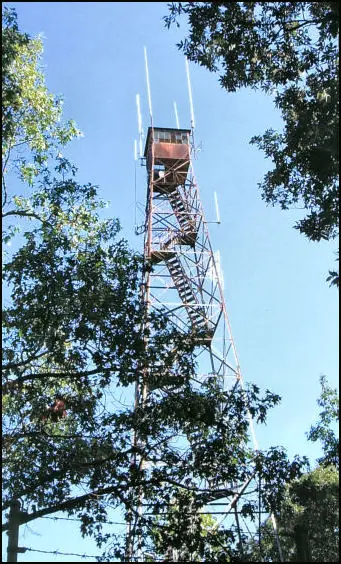
1968 Aermotor tower built by the Alabama Forestry Commission at Monte Sano State Park; taken down and rebuilt at Fire Tower Camp near Crane Hill, reported Sept 2025.
- Standing
- Permission required
- Verified
Permission required
You need permission from the tribe or landowner before visiting. Stands on the grounds of Fire Tower Camp near Crane Hill. The camp invites visitors to climb it; the sources give no hours, fees or rules.
Visit & stay
Not rentable. As far as we know, this lookout cannot be booked for overnight stays.
Access
Permission required. See the warning at the top of this page.
- Can you climb it?
- Yes
- Road to the top?
- Unknown
- Trail
- Listed on the camp's hiking page with its other trails and landmarks. Check with the camp before going.
- Staffing
- Unknown
Facts
- Status
- Type
- Cab on a tower100-foot Aermotor tower with 7 by 7 foot metal cab, galvanized steelThe design: Aermotor
- Built of
- SteelGoing by its design; no source says so in words.
- Built
- 1968
- Height
- 100 ft (30.5 m)
- Elevation
- 1,598 ft (487 m)
- Agency
- Alabama Forestry Commission (built 1968); State of Alabama, Monte Sano State Park (administrator per NHLR); Fire Tower Camp (current site per Alabama Living)
- Land
- State land
- Location
- Madison County, Alabama
- Coordinates
- 34.73138, −86.50450
- Registers
- This entry
- VerifiedResearched, then checked independently. Updated 8 Oct 2026.
- Firefinder id
us-al-joe-b-shirley
View from the cab
What you see from the cab: every ridge out to about 93 miles, the named peaks in sight, and other fire lookouts within view, worked out from terrain data in your browser.
Downloads about 3.1 MB of terrain data the first time.
Or see what it could see on the map: the ground in its line of sight.
History
Then and now
- 1968 BuiltBuilt by the Alabama Forestry Commission as an Aermotor tower; replaced an earlier wooden tower dating to the 1940sSources: nhlr.org, hmdb.org
- No record between 1968 and 2006
- 2006 Added to the National Historic Lookout RegisterRegistered October 18, 2006 as US 680, AL 3, nominated by Jane Barr of the Monte Sano Historical AssociationSources: nhlr.org, hmdb.org
- No record between 2006 and 2025
- 2025 MovedReported in September 2025 as taken down at Monte Sano and being rebuilt at Fire Tower Camp, Crane Hill. The move date is not given in any source read.Source: alabamaliving.coop
- TodayStandingIt still stands, as far as our sources know.
Old maps of this spot
USGS topographic maps from the years a lookout stood may show it, often as a small symbol labelled “Lookout”. See the old topo maps around it on the Firefinder map, or find every scanned sheet of this spot on USGS TopoView (opens another site) (click the spot there to list them, with dates and downloads).
Story
Researched 9 Oct 2026, fact-checked.
The Joe B. Shirley Fire Tower was built in 1968 by the Alabama Forestry Commission to replace a wooden lookout from the 1940s.1,2 It is an Aermotor model 100 feet tall, with a 7-by-7-foot metal cab, and Alabama Living says it is made of galvanized steel.1,3
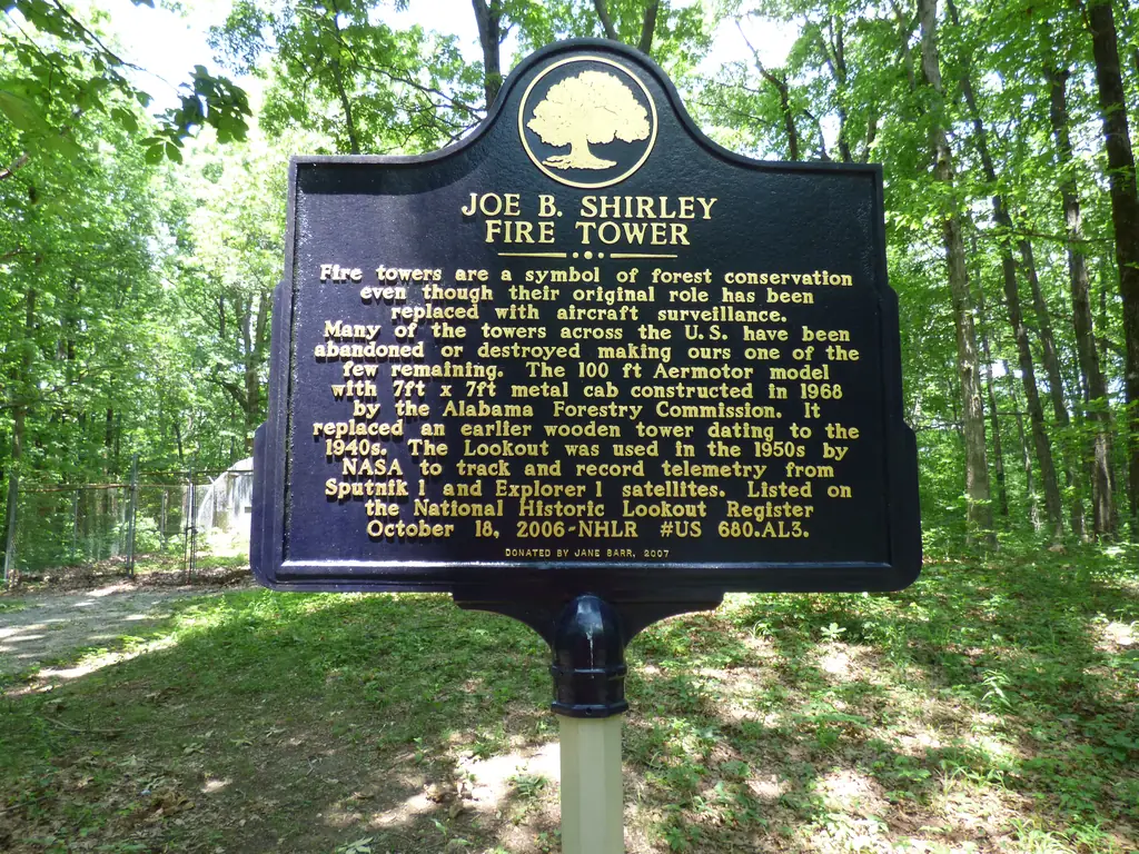
It stood at Monte Sano State Park in Huntsville.3 A historical marker treats fire towers as emblems of forest conservation, even though aircraft have taken over their original job.2 The Register listed the tower on October 18, 2006, on a nomination from Jane Barr of the Monte Sano Historical Association.1
None of the sources read say who staffed the tower or which fires it watched. The Register and the marker both say NASA used the lookout in the 1950s to log telemetry from the Sputnik and Explorer satellites.1,2 That predates the 1968 tower, so the claim most likely refers to the earlier wooden lookout, though no source says so.
For years the tower was a landmark at the park, but visitors could not climb it.3 Huntsville businessman Billy Claunch heard it was for sale and set out to buy it.3 Alabama Living reported in September 2025 that it had been taken down and was being rebuilt at Fire Tower Camp near Crane Hill in Cullman County.3 The historical marker itself is listed in a marker database as being in storage.2
Fire Tower Camp, which rents cabins and a treehouse on Smith Lake, now describes the restored tower as a 109-foot climb.4,5 The Register gives the height as 100 feet, so the two figures disagree, and the sources do not explain whether the rebuild changed the height.1,4 Alabama Living expected the work to be finished in late 2025 or early 2026, but the sources do not confirm an opening date.3 Ask the camp about hours, fees and conditions before you go, and do not climb the tower unless the camp says it is open.5
- Joe B. Shirley Fire Tower, National Historic Lookout Register (nhlr.org), http://nhlr.org/lookouts/us/al/joe-b-shirley-fire-tower/ (accessed 2026-10-09). ↩
- Joe B. Shirley Fire Tower Historical Marker, Historical Marker Database (hmdb.org), https://www.hmdb.org/m.asp?m=297521 (accessed 2026-10-09). ↩
- A Historic Fire Tower Finds New Life at Smith Lake, Alabama Living Magazine, September 1, 2025, https://alabamaliving.coop/articles/rebuilding-history/ (accessed 2026-10-09). ↩
- Hiking, Fire Tower Camp, https://www.firetowercamp.com/hiking-574029064 (accessed 2026-10-09). ↩
- Fire Tower Camp, home page, https://www.firetowercamp.com/ (accessed 2026-10-09). ↩
Photos
Photos keep their own rights and are shown with credit. Is one of these yours? You can ask for a different credit or for removal.
Sources
- National Historic Lookout Register (NHLR) (opens another site) Gave us: name, location, county, elevation, what it is built of, status, register numbers, agency, ownership, dates, photos, links National Historic Lookout Register (nhlr.org) · All rights reserved (American Resources, Inc.); facts extracted only, no prose copied. · retrieved 4 Oct 2026
- OpenStreetMap -- fire lookout structures (opens another site) Gave us: type, height, links © OpenStreetMap contributors · ODbL 1.0. (c) OpenStreetMap contributors. · retrieved 4 Oct 2026
- Firefinder research Gave us: summary, design, height, status, agency, access, visiting details, dates, links, fact-check Firefinder research (sources cited in the story footnotes) · Our own research notes; each fact cites its source in the lookout's story
More about this lookout elsewhere
- NHLR register entry US 680 (nhlr.org) (opens another site)
- A Historic Fire Tower Finds New Life at Smith Lake (Alabama Living Magazine) (opens another site)
- Joe B. Shirley Fire Tower Historical Marker (Historical Marker Database (hmdb.org)) (opens another site)
- Hiking (Fire Tower Camp) (opens another site)
- Fire Tower Camp (Fire Tower Camp (home page)) (opens another site)
- OpenStreetMap node 358966157 (opens another site)
Firefinder takes facts (places, dates, numbers) from these sources and writes its own words. See all sources and licences.