Fire lookout · Baxter County, Arkansas
Push Mountain Firetower
A 1929 60-foot Aermotor LX-25 fire tower in Baxter County, Arkansas, kept by lookout keepers in the 1930s and 1940s, NHLR-registered in 2003 and listed as standing in 2023.
- Standing
- Access unknown
- Verified
Visit & stay
Not rentable. As far as we know, this lookout cannot be booked for overnight stays.
Access
Access unknown
We do not know the access rules. Check with the land manager before you go.
- Can you climb it?
- Unknown
- Road to the top?
- Unknown
- Staffing
- Unknown
Facts
- Status
- Type
- Cab on a tower60-foot Aermotor LX-25 steel tower with a 7 by 7 metal cab; ladder-style steps between landingsThe design: Aermotor LX-24 / LX-25
- Built of
- SteelGoing by its design; no source says so in words.
- Built
- 1929
- Height
- 60 ft (18.3 m)
- Elevation
- 1,234 ft (376 m)
- Agency
- U.S. Forest Service
- Land
- Federal land
- Location
- Baxter County, Arkansas
- Coordinates
- 36.08450, −92.37017 sources disagree
- Registers
- This entry
- VerifiedResearched, then checked independently. Updated 8 Oct 2026.
- Firefinder id
us-ar-push-mountain
View from the cab
What you see from the cab: every ridge out to about 93 miles, the named peaks in sight, and other fire lookouts within view, worked out from terrain data in your browser.
Downloads about 3.1 MB of terrain data the first time.
Or see what it could see on the map: the ground in its line of sight.
History
Then and now
- 1929 BuiltErected in 1929 on the Ozark National Forest; NHLR and the forest-lookout site agree on the yearSources: nhlr.org, centraluslookouts.weebly.com
- 1934 StaffedC. W. Pemberton and family moved in as keeper for the coming year, per a January 5, 1934 Baxter Bulletin noticeSource: centraluslookouts.weebly.com
- 1936 StaffedCarba Pemberton, long-serving look-out man, resigned in July 1936 and planned to vacate within daysSource: centraluslookouts.weebly.com
- 1938 StaffedW. C. Norman described as keeping the tower; notices name him through 1943Source: centraluslookouts.weebly.com
- No record between 1938 and 2003
- 2003 Added to the National Historic Lookout RegisterRegistered with the National Historic Lookout Register April 25, 2003; nominated by Michael A. Pfeiffer and Sue FosterSource: nhlr.org
- No record between 2003 and 2023
- 2023 Condition assessmentListed as standing based on Google Earth imagerySource: centraluslookouts.weebly.com
- TodayStandingIt still stands, as far as our sources know.
Old maps of this spot
USGS topographic maps from the years a lookout stood may show it, often as a small symbol labelled “Lookout”. See the old topo maps around it on the Firefinder map, or find every scanned sheet of this spot on USGS TopoView (opens another site) (click the spot there to list them, with dates and downloads).
Story
Researched 8 Oct 2026, fact-checked.
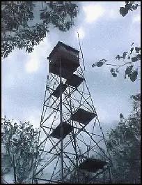
Push Mountain Firetower stands in Baxter County, Arkansas, inside the Ozark–St. Francis National Forest.1 It was erected in 1929 on what was then the Ozark National Forest.1 The 60-foot tower is an Aermotor LX-25 steel structure, and it carries a 7-by-7 metal cab.1,2 Its climb is unusual. The steps between the landings are ladders rather than stairs, a design that falls between the older exterior ladders and the interior stairs that came later.1
For much of the 1930s and early 1940s the tower had resident keepers, and newspaper notices from The Baxter Bulletin, copied out on a forest-lookout website, name them.2 In January 1934 C. W. Pemberton and his family moved to the tower to serve as its keeper for the coming year.2 Carba Pemberton, who had worked the lookout for a long time, resigned in July 1936.2 From 1938 to 1943 the notices name W. C. Norman as keeper, and his family went back and forth between the tower and their house in town.2 The sources do not say when the tower was last staffed, and none of them names a particular fire it spotted.
The tower was registered on the National Historic Lookout Register on April 25, 2003, after a nomination by Michael A. Pfeiffer and Sue Foster.1 The forest-lookout website reports it as standing in 2023, based on Google Earth imagery.2 I found no record of it being moved, rebuilt or burned.
The U.S. Forest Service administers the tower, with the Sylamore Ranger District as a cooperator.1 Arkansas counted more than 120 fire towers at its peak, and by 2023 forty-six were still standing.3 None of the sources says whether Push Mountain is open to visitors or safe to climb, so check with the Sylamore Ranger District before going near it.
- Push Mountain Firetower, National Historic Lookout Register, http://nhlr.org/lookouts/us/ar/push-mountain-firetower/ (accessed 2026-10-08). ↩
- Push Mountain - FOREST LOOKOUTS, Forest Lookouts site (centraluslookouts.weebly.com), https://centraluslookouts.weebly.com/push-mountain.html (accessed 2026-10-08). ↩
- Forest Fire Lookouts, Encyclopedia of Arkansas, https://encyclopediaofarkansas.net/entries/forest-fire-lookouts-7905/ (accessed 2026-10-08). ↩
Photos
Photos keep their own rights and are shown with credit. Is one of these yours? You can ask for a different credit or for removal.
Where sources disagree
We show disagreements between sources instead of quietly picking one. If you know which is right, please tell us.
Sources disagree on the location by 520 m.
- NHLR: 36.08450, −92.37017
- OpenStreetMap: 36.07997, −92.37165
The map uses the position from NHLR.
Sources
- National Historic Lookout Register (NHLR) (opens another site) Gave us: name, location, county, elevation, status, register numbers, agency, ownership, dates, photos, links National Historic Lookout Register (nhlr.org) · All rights reserved (American Resources, Inc.); facts extracted only, no prose copied. · retrieved 4 Oct 2026
- FOREST LOOKOUTS -- central US (centraluslookouts.weebly.com) (opens another site) Gave us: what it is built of, design, height, links centraluslookouts.weebly.com · No licence stated; facts only (county, coordinates where the page's own map widget gives them, status, height, design hints, register links). The site's own historical quotes, newspaper citations and narrative are not reproduced. · retrieved 8 Oct 2026
- OpenStreetMap -- fire lookout structures (opens another site) Gave us: type, links © OpenStreetMap contributors · ODbL 1.0. (c) OpenStreetMap contributors. · retrieved 4 Oct 2026
- Firefinder research Gave us: summary, design, height, status, agency, dates, links, fact-check Firefinder research (sources cited in the story footnotes) · Our own research notes; each fact cites its source in the lookout's story
More about this lookout elsewhere
- NHLR register entry US 510 (nhlr.org) (opens another site)
- NHLR register entry (nhlr.org) (opens another site)
- Forest Fire Lookouts (Encyclopedia of Arkansas) (opens another site)
- Push Mountain (centraluslookouts.weebly.com) (opens another site)
- OpenStreetMap node 359010507 (opens another site)
Firefinder takes facts (places, dates, numbers) from these sources and writes its own words. See all sources and licences.