Fire lookout · Coconino County, Arizona
Baker Butte Lookout
Coconino NF lookout on Baker Butte: a 1936 CCC-built cab on a 30-foot Aermotor, earlier tower dates disputed, staffed for decades; still standing.
- Standing
- Access unknown
- Verified
Visit & stay
Not rentable. As far as we know, this lookout cannot be booked for overnight stays.
Access
Access unknown
We do not know the access rules. Check with the land manager before you go.
- Can you climb it?
- Unknown
- Road to the top?
- Unknown
- Staffing
- Unknown
Facts
- Status
- Type
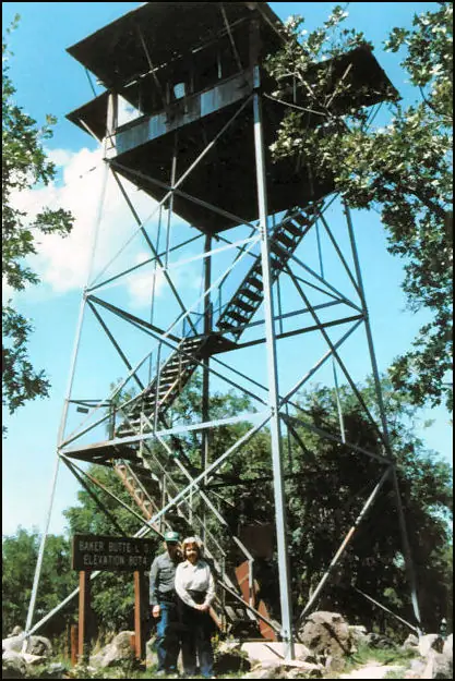
- Cab on a tower12x12 wooden live-in cab without catwalk (steel catwalk added 2008) on a 30-foot Aermotor MC-24 metal towerThe designs: Aermotor MC-24, Region 3 cab
- Built of
- SteelGoing by its design; no source says so in words.
- Built
- 1921
- Height
- 30 ft (9.1 m)
- Elevation
- 8,074 ft (2,461 m)
- Agency
- U.S. Forest Service (Coconino National Forest, Mogollon Rim District)
- Land
- Federal land
- Location
- Coconino County, Arizona
- Coordinates
- 34.44944, −111.37694
- Registers
- This entry
- VerifiedResearched, then checked independently. Updated 8 Oct 2026.
- Firefinder id
us-az-baker-butte
View from the cab
What you see from the cab: every ridge out to about 93 miles, the named peaks in sight, and other fire lookouts within view, worked out from terrain data in your browser.
Downloads about 3.0 MB of terrain data the first time.
Or see what it could see on the map: the ground in its line of sight.
History
Then and now
- 1912 EventChosen as a primary lookout with a man stationed at all times and a telephone link to the supervisor's officeSource: westlookouts.weebly.com
- 1915 First staffedH.C. Johns reported for duty as lookout man; a cabin was built for the lookoutSource: westlookouts.weebly.com
- 1921 BuiltFirst tower per NHLR: 6x6 wooden cab on 20-ft metal tower with ladder access. A 1922 letter describes buying a different tower, so the dates disagreeSources: nhlr.org, westlookouts.weebly.com
- No record between 1921 and 1936
- 1936 Built'Built' field on NHLR detail pageSource: NHLR register entry
- 1936 Replaced by a new structureCCC replaced the first tower with the present R-3 12x12 cab on a 30-ft Aermotor MC-24; NHLR lists the build year as 1936Source: nhlr.org
- 1937 Condition assessmentForest Service officials dispute the foundation design; a June 1937 memo says the tower was not yet completeSource: westlookouts.weebly.com
- 1939 Event27-mile Forest Service telephone line planned from the tower to Long Valley ranger stationSource: westlookouts.weebly.com
- 1948 EventRadio lookout sets planned for the Baker Butte stationSource: westlookouts.weebly.com
- 1953 StaffedLookout usually occupied from early spring until late fall or early winterSource: westlookouts.weebly.com
- No record between 1953 and 1973
- 1973 StaffedLookout officer snowed in during November and rescued by forest rangersSource: westlookouts.weebly.com
- No record between 1973 and 2006
- 2006 Added to the National Historic Lookout RegisterRegistered on the National Historic Lookout Register March 15, 2006Source: nhlr.org
- 2008 AlteredSteel catwalk added in the fallSource: westlookouts.weebly.com
- TodayStandingIt still stands, as far as our sources know.
Old maps of this spot
USGS topographic maps from the years a lookout stood may show it, often as a small symbol labelled “Lookout”. See the old topo maps around it on the Firefinder map, or find every scanned sheet of this spot on USGS TopoView (opens another site) (click the spot there to list them, with dates and downloads).
Story
Researched 8 Oct 2026, fact-checked.
Baker Butte sits on the Mogollon Rim District of the Coconino National Forest.1 In January 1912 the Forest Service chose it as a primary lookout, with a man to be stationed there at all times and a telephone connection to the supervisor's office.2 A cabin was built for the lookout in 1915, and H.C. Johns reported for duty there as a lookout man in April of that year.2
The register dates the first tower to 1921 and describes a six-by-six wooden cab atop a 20-foot metal tower, climbed by ladder.1 Forest Service letters complicate that picture. In late 1920 officials hoped to swap the old wooden tower for a steel one, and in August 1922 a tower was bought from a Wisconsin company, though the forest supervisor judged its material too light.2 The sources disagree on when the first tower went up, and this history cannot settle it.
In 1936 the Civilian Conservation Corps replaced the first tower with the present 12-by-12 live-in cab on a 30-foot Aermotor MC-24 tower.1 The register notes that the cab had no catwalk.1 A June 1937 exchange over the foundation included a memo saying the tower had not yet been completed, so the work seems to have run into 1937.2
Communications and staffing both turn up in the records. A 1939 plan called for a 27-mile telephone line from the tower to the Long Valley ranger station, and a 1948 plan included radio sets for the Baker Butte station.2 A 1953 request for a heater noted the lookout was usually occupied from early spring until late fall or early winter.2 In November 1973 a lookout officer was snowed in and had to be rescued by rangers.2
Today the tower is listed as standing.3 A steel catwalk was added in 2008, and the register recorded the lookout on March 15, 2006.2,1 I found no current staffing report, rental listing or public visiting guidance for Baker Butte. The register says towers available for rent are marked on its listing pages, and this one carries no such mark.4,1
- Baker Butte Lookout, National Historic Lookout Register, http://nhlr.org/lookouts/us/az/baker-butte-lookout/ (accessed 2026-10-08). ↩
- Baker Butte - Forest Lookouts, West Lookouts, https://westlookouts.weebly.com/baker-butte.html (accessed 2026-10-08). ↩
- Arizona Lookouts (by County), Forest Fire Lookout Association, https://firelookout.org/lookouts/us/az/ (accessed 2026-10-08). ↩
- Rentals, National Historic Lookout Register, http://nhlr.org/rentals/ (accessed 2026-10-08). ↩
Photos
Photos keep their own rights and are shown with credit. Is one of these yours? You can ask for a different credit or for removal.
Sources
- National Historic Lookout Register (NHLR) (opens another site) Gave us: name, location, county, elevation, register numbers, agency, ownership, dates, photos, links National Historic Lookout Register (nhlr.org) · All rights reserved (American Resources, Inc.); facts extracted only, no prose copied. · retrieved 4 Oct 2026
- Forest Fire Lookout Association (FFLA) - US lookout lists (opens another site) Gave us: type, status, register numbers, links Forest Fire Lookout Association (firelookout.org) · No licence stated; facts extracted only, no prose copied. · retrieved 8 Oct 2026
- FOREST LOOKOUTS -- western US (Ron Kemnow's weebly sites) (opens another site) Gave us: what it is built of, design, links Ron Kemnow's Forest Lookouts sites (westlookouts, californialookouts, idaholookouts, montanalookouts, oregonlookouts and washingtonlookouts .weebly.com) · No licence stated; facts only (county, land manager, status word, coordinates where the page's own map widget gives them, township-range-section, height and design hints, links). The site's own newspaper quotes, citations and narrative are not reproduced. · retrieved 8 Oct 2026
- Firefinder research Gave us: summary, design, height, status, agency, dates, links, fact-check Firefinder research (sources cited in the story footnotes) · Our own research notes; each fact cites its source in the lookout's story
More about this lookout elsewhere
- NHLR register entry US 675 (nhlr.org) (opens another site)
- NHLR register entry (nhlr.org) (opens another site)
- Rentals (National Historic Lookout Register) (opens another site)
- FFLA Arizona lookout list (firelookout.org) (opens another site)
- Baker's Butte on Forest Lookouts, western US (Ron Kemnow) (opens another site)
Firefinder takes facts (places, dates, numbers) from these sources and writes its own words. See all sources and licences.