Fire lookout · Coconino County, Arizona
Bill Williams Mountain Lookout
Also known as Bill Williams
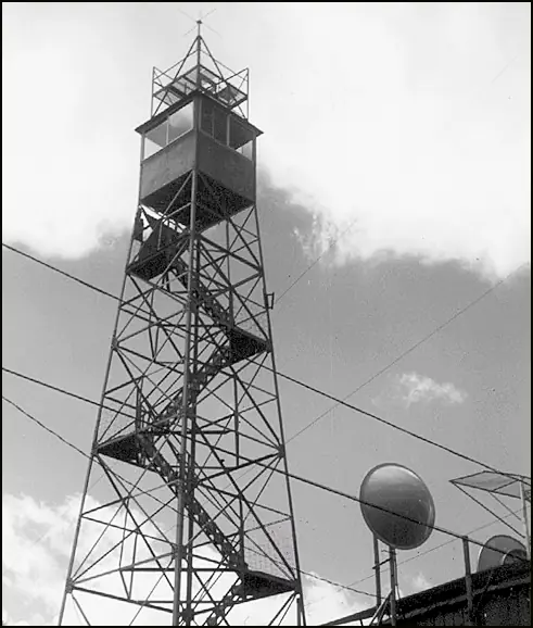
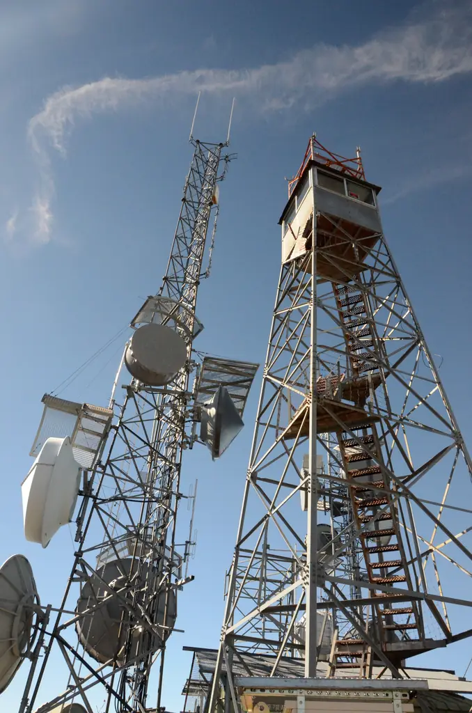
A 1937 Aermotor fire tower with a raised-platform cab on Bill Williams Mountain above Williams, Arizona; the register lists it in active service.
- Standing
- Restricted access
- Verified
Visit & stay
Not rentable. As far as we know, this lookout cannot be booked for overnight stays.
Access
Restricted access
Access is seasonal, gated or needs a permit. Check before you go. Open to visitors during fire season according to an undated Arizona Highways article. Current opening not confirmed. The summit road serves radio towers.
- Can you climb it?
- Unknown
- Road to the top?
- Unknown
- Trail
- Trail starts at the Williams Ranger District station about a mile from downtown Williams. The route crosses Forest Road 111, which serves the radio towers on the summit.
- Staffing
- Unknown
Facts
- Status
- Type
- Cab on a towerAermotor MC-39 tower with a 7' x 7' metal cab and a raised platform above the roofThe design: Aermotor MC-39
- Built of
- SteelGoing by its design; no source says so in words.
- Built
- 1924
- Height
- 45 ft (13.7 m)
- Elevation
- 9,166 ft (2,794 m)
- Agency
- U.S. Forest Service, Kaibab National Forest (Williams Ranger District)
- Land
- Federal land
- Location
- Coconino County, Arizona
- Coordinates
- 35.19940, −112.20420
- Registers
- This entry
- VerifiedResearched, then checked independently. Updated 8 Oct 2026.
- Firefinder id
us-az-bill-williams-mountain
View from the cab
What you see from the cab: every ridge out to about 93 miles, the named peaks in sight, and other fire lookouts within view, worked out from terrain data in your browser.
Downloads about 3.2 MB of terrain data the first time.
Or see what it could see on the map: the ground in its line of sight.
History
Then and now
- 1910 EventSpruce tree topped with a small platform, used as a patrol lookoutSource: westlookouts.weebly.com
- 1917 StaffedCharles Cattermole arrives in Williams from Prescott in May 1917 to start as lookoutSource: westlookouts.weebly.com
- 1924 Built30-foot wooden tower constructedSources: nhlr.org, westlookouts.weebly.com
- 1937 BuiltPresent Aermotor MC-39 tower erected with an airway beacon on topSources: nhlr.org, westlookouts.weebly.com
- 1938 StaffedLookout Floyd Barker observes two bull elk fight near his cabinSource: westlookouts.weebly.com
- No record between 1938 and 1954
- 1954 EventRoad to the summit completed for fire control; closed to the publicSources: westlookouts.weebly.com, arizonahighways.com
- No record between 1954 and 2001
- 2001 Added to the National Historic Lookout RegisterRegistered May 1, 2001Source: nhlr.org
- TodayStandingIt still stands, as far as our sources know.
Old maps of this spot
USGS topographic maps from the years a lookout stood may show it, often as a small symbol labelled “Lookout”. See the old topo maps around it on the Firefinder map, or find every scanned sheet of this spot on USGS TopoView (opens another site) (click the spot there to list them, with dates and downloads).
Story
Researched 8 Oct 2026, fact-checked.
Bill Williams Mountain has had a lookout since at least 1910.1 The first was an old spruce tree topped with a small platform, used as a patrol lookout in 1910.1 A 30-foot wooden tower followed in 1924.2,1 The present Aermotor MC-39 tower dates to 1937.2,1 It has a 7-by-7-foot metal cab with an unusual raised platform above the roof, and an airway beacon was mounted on top.2,1 A 1939 newspaper item ranked the beacon among the country's highest.1
The people who worked it left traces in the local papers. Charles Cattermole arrived in Williams from Prescott in May 1917 to start as lookout.1 In October 1938 Floyd Barker, standing in the tower, heard and then watched two bull elk fight in the clearing behind his cabin.1 A road to the summit was pushed through in 1954, built mainly for fire control, and it was not open to the public.1,3
The register recorded the lookout on May 1, 2001, and describes the tower as in active service.2 The Fire Lookout Association lists it as a standing tower.4 The sources also disagree about the elevation. The register gives the summit at 9,166 feet, while 1935 and 1939 newspaper items give 9,264 and 9,242 feet.2,1
Today the summit is a radio site.3,5 In January 2014 the Forest Service signed a decision to raise an existing 71-foot lattice telecommunications tower on the summit to 100 feet.5 An undated Arizona Highways article says the trail starts at the Williams Ranger District station and that the lookout is open to visitors during the fire season.3 I could not find a current staffing or opening notice for this October, so the season may already be over. Check with the Williams Ranger District before you go, and do not climb the tower unless it is open to visitors.
- Bill Williams Mountain, Forest Lookouts, western US (Ron Kemnow), https://westlookouts.weebly.com/bill-williams-mountain.html (accessed 2026-10-08). ↩
- Bill Williams Mountain Lookout, National Historic Lookout Register, http://nhlr.org/lookouts/us/az/bill-williams-mountain-lookout/ (accessed 2026-10-08). ↩
- Bill Williams Trail, Arizona Highways, https://www.arizonahighways.com/bill-williams-trail-0 (undated article, accessed 2026-10-08). ↩
- Arizona lookouts, Forest Fire Lookout Association, https://firelookout.org/lookouts/us/az/ (accessed 2026-10-08). ↩
- Bill Williams Mountain Communications Tower Height Extension, Kaibab National Forest, U.S. Forest Service, https://www.fs.usda.gov/r03/kaibab/projects/43443 (accessed 2026-10-08). ↩
Photos

Photos keep their own rights and are shown with credit. Is one of these yours? You can ask for a different credit or for removal.
Sources
- National Historic Lookout Register (NHLR) (opens another site) Gave us: name, location, county, elevation, register numbers, agency, ownership, dates, photos, links National Historic Lookout Register (nhlr.org) · All rights reserved (American Resources, Inc.); facts extracted only, no prose copied. · retrieved 4 Oct 2026
- Forest Fire Lookout Association (FFLA) - US lookout lists (opens another site) Gave us: type, status, register numbers, links Forest Fire Lookout Association (firelookout.org) · No licence stated; facts extracted only, no prose copied. · retrieved 8 Oct 2026
- Wikidata -- US fire lookout towers (Q748998 and subclasses) (opens another site) Gave us: height, dates, photos, links Wikidata · CC0 1.0 (Wikidata). Images keep their own Commons licence/credit. · retrieved 4 Oct 2026
- FOREST LOOKOUTS -- western US (Ron Kemnow's weebly sites) (opens another site) Gave us: what it is built of, design, links Ron Kemnow's Forest Lookouts sites (westlookouts, californialookouts, idaholookouts, montanalookouts, oregonlookouts and washingtonlookouts .weebly.com) · No licence stated; facts only (county, land manager, status word, coordinates where the page's own map widget gives them, township-range-section, height and design hints, links). The site's own newspaper quotes, citations and narrative are not reproduced. · retrieved 8 Oct 2026
- Firefinder research Gave us: summary, design, agency, access, visiting details, dates, links, fact-check Firefinder research (sources cited in the story footnotes) · Our own research notes; each fact cites its source in the lookout's story
More about this lookout elsewhere
- NHLR register entry US 384 (nhlr.org) (opens another site)
- NHLR register entry (nhlr.org) (opens another site)
- Bill Williams Trail (undated article) (Arizona Highways) (opens another site)
- Bill Williams Mountain Communications Tower Height Extension (Kaibab National Forest, U.S. Forest Service) (opens another site)
- FFLA Arizona lookout list (firelookout.org) (opens another site)
- Bill Williams Mountain on Forest Lookouts, western US (Ron Kemnow) (opens another site)
- Wikidata item Q86926387 (opens another site)
Firefinder takes facts (places, dates, numbers) from these sources and writes its own words. See all sources and licences.