Fire lookout · Cochise County, Arizona
Monte Vista Lookout
Also known as Monte Vista Peak Lookout
A 1966 steel tower on Monte Vista Peak in the Chiricahua Mountains, still an active Forest Service lookout, reached on foot by trail.
- Standing
- Open to the public
- Verified
Visit & stay
Not rentable. As far as we know, this lookout cannot be booked for overnight stays.
Access
Open to the public. Reached on foot by trail. The cab is an active Forest Service station. The sources give no visitor entry rule for the cab.
- Can you climb it?
- Unknown
- Road to the top?
- No, you have to hike
- Trail
- Trailheads in the Turkey Creek area (Morse Canyon Trail #43 or Pole Bridge Trail #264) and in the Rucker Canyon area, including one at the end of Forest Road 628 off FR-74E.
- Staffing
- Unknown
Facts
- Status
- Type
- Cab on a tower40-ft steel tower with USDA CL-100 metal cab, 14 ft by 14 ft (1966 replacement)The designs: CL-100, Aermotor
- Built of
- Steel
- Built
- 1916
- Height
- 40 ft (12.2 m)
- Elevation
- 9,480 ft (2,890 m)
- Agency
- U.S. Forest Service
- Land
- Federal land
- Location
- Cochise County, Arizona
- Coordinates
- 31.82491, −109.31458
- Registers
- This entry
- VerifiedResearched, then checked independently. Updated 8 Oct 2026.
- Firefinder id
us-az-monte-vista
View from the cab
What you see from the cab: every ridge out to about 93 miles, the named peaks in sight, and other fire lookouts within view, worked out from terrain data in your browser.
Downloads about 3.0 MB of terrain data the first time.
Or see what it could see on the map: the ground in its line of sight.
History
Then and now
- 1916 BuiltOriginal crow's nest towerSources: nhlr.org, gvrhc.org
- 1922 Replaced by a new structure30-ft Aermotor tower replaced the crow's nestSources: nhlr.org, gvrhc.org
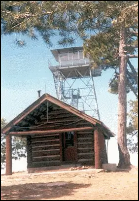
- 1933 BuiltSupport cabin at the base of the lookout, built by the CCC. This is the NRHP-listed cabin, not the tower.Source: en.wikipedia.org
- No record between 1933 and 1956
- 1956 FireErroneous report that the support cabin had been destroyed in a forest fire (per Wikipedia)Source: en.wikipedia.org
- 1966 Replaced by a new structureCurrent 40-ft steel tower with CL-100 14x14 cabSources: nhlr.org, gvrhc.org
- No record between 1966 and 1988
- 1988 Listed on the National Register of Historic PlacesMonte Vista Lookout Cabin added to the National Register, January 28, 1988Source: en.wikipedia.org
- No record between 1988 and 2003
- 2003 Added to the National Historic Lookout RegisterRegistered on the National Historic Lookout Register, January 31, 2003Source: nhlr.org
- 2011 FireHorseshoe II fire ravaged much of the Chiricahua Mountains and destroyed Barfoot Lookout; it came close to Monte Vista but bypassed the siteSource: gvrhc.org
- 2013 Staffed2013 summary: lookout is active and generally manned during the high fire danger seasonSource: gvrhc.org
- TodayStandingIt still stands, as far as our sources know.
Old maps of this spot
USGS topographic maps from the years a lookout stood may show it, often as a small symbol labelled “Lookout”. See the old topo maps around it on the Firefinder map, or find every scanned sheet of this spot on USGS TopoView (opens another site) (click the spot there to list them, with dates and downloads).
Story
Researched 8 Oct 2026, fact-checked.
Monte Vista Lookout sits in the southern Chiricahua Mountains, in the Coronado National Forest, at about 9,480 feet.1,2 The site has had three towers over its life.2 A crow's nest tower went up in 1916, a 30-foot Aermotor tower replaced it in 1922, and the current 40-foot steel tower with a 14-by-14-foot CL-100 cab dates to 1966.1,2
A support cabin at the base of the lookout was built by the Civilian Conservation Corps in 1933.3 The National Register listing, added January 28, 1988, is for that cabin, not the tower.3 Wikipedia also says a 1956 report that the cabin had been destroyed in a forest fire was wrong.3
In 2011 the Horseshoe II fire burned across much of the Chiricahua Mountains and destroyed Barfoot Lookout, but it passed near Monte Vista without reaching the site.2 The register listed the tower on January 31, 2003,1 and a 2013 Green Valley Hiking Club summary called the lookout active and usually staffed in the high-danger part of fire season.2
Getting there is on foot.2 The Green Valley Hiking Club describes trailheads in the Turkey Creek area, such as Morse Canyon Trail #43 or Pole Bridge Trail #264, plus two Rucker Canyon routes, one starting at the end of Forest Road 628.2 The sources say nothing about visitors entering the cab, and the register lists the station in active service, so treat it as a working lookout to see from the trail rather than a tower to climb.1,2
- Monte Vista Lookout, National Historic Lookout Register, http://nhlr.org/lookouts/us/az/monte-vista-lookout/ (accessed 2026-10-08). ↩
- Monte Vista Fire Lookout, Green Valley Hiking Club (summary by Tom Johnson, June 2013), https://www.gvrhc.org/Library/MonteVistaFireLookout.pdf (accessed 2026-10-08). ↩
- Monte Vista Lookout Cabin, Wikipedia, https://en.wikipedia.org/wiki/Monte_Vista_Lookout_Cabin (accessed 2026-10-08). ↩
Photos
Photos keep their own rights and are shown with credit. Is one of these yours? You can ask for a different credit or for removal.
Sources
- National Historic Lookout Register (NHLR) (opens another site) Gave us: name, location, county, elevation, what it is built of, register numbers, agency, ownership, dates, photos, links National Historic Lookout Register (nhlr.org) · All rights reserved (American Resources, Inc.); facts extracted only, no prose copied. · retrieved 4 Oct 2026
- Forest Fire Lookout Association (FFLA) - US lookout lists (opens another site) Gave us: type, status, register numbers, links Forest Fire Lookout Association (firelookout.org) · No licence stated; facts extracted only, no prose copied. · retrieved 8 Oct 2026
- Wikidata -- US fire lookout towers (Q748998 and subclasses) (opens another site) Gave us: links Wikidata · CC0 1.0 (Wikidata). Images keep their own Commons licence/credit. · retrieved 4 Oct 2026
- OpenStreetMap -- fire lookout structures (opens another site) Gave us: height, links © OpenStreetMap contributors · ODbL 1.0. (c) OpenStreetMap contributors. · retrieved 4 Oct 2026
- FOREST LOOKOUTS -- western US (Ron Kemnow's weebly sites) (opens another site) Gave us: links Ron Kemnow's Forest Lookouts sites (westlookouts, californialookouts, idaholookouts, montanalookouts, oregonlookouts and washingtonlookouts .weebly.com) · No licence stated; facts only (county, land manager, status word, coordinates where the page's own map widget gives them, township-range-section, height and design hints, links). The site's own newspaper quotes, citations and narrative are not reproduced. · retrieved 8 Oct 2026
- Firefinder research Gave us: summary, design, height, status, agency, access, visiting details, dates, links, fact-check Firefinder research (sources cited in the story footnotes) · Our own research notes; each fact cites its source in the lookout's story
More about this lookout elsewhere
- NHLR register entry US 449 (nhlr.org) (opens another site)
- Monte Vista Fire Lookout (summary prepared June 2013) (Green Valley Hiking Club) (opens another site)
- Monte Vista Lookout Cabin (Wikipedia) (opens another site)
- FFLA Arizona lookout list (firelookout.org) (opens another site)
- Monte Vista on Forest Lookouts, western US (Ron Kemnow) (opens another site)
- Wikidata item Q86928998 (opens another site)
- OpenStreetMap way 183250211 (opens another site)
Firefinder takes facts (places, dates, numbers) from these sources and writes its own words. See all sources and licences.