Fire lookout · Coconino County, Arizona
O'Leary Lookout
Also known as O'Leary Peak Lookout Tower
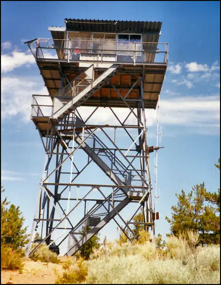
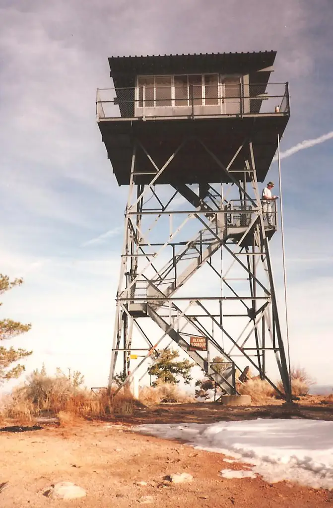
A 1959 Forest Service tower on O'Leary Peak north of Flagstaff, occupied from 1959 by a Flagstaff gunsmith and registered in 2006; the approach road has an active access alert.
- Standing
- Restricted access
- Verified
Visit & stay
Not rentable. As far as we know, this lookout cannot be booked for overnight stays.
Access
Restricted access
Access is seasonal, gated or needs a permit. Check before you go. Forest Service alert says O'Leary access is restricted and NPS Road 545 is closed between SR 89 and Sunset Crater. The blocked forest road leaves about a mile of hiking to the base of the peak.
- Can you climb it?
- Unknown
- Road to the top?
- No, you have to hike
- Trail
- Walk from the blocked forest road about a mile to the base of the peak, then six switchbacks to the tower, which sits on a neighboring summit.
- Staffing
- Unknown
Facts
- Status
- Type
- Cab on a tower14 x 14 ft CL-100 series live-in cab with catwalk on a metal tower (register); a 1959 build log says 30 ftThe design: CL-100
- Built of
- Steel
- Built
- 1959
- Height
- 32 ft (9.8 m)
- Elevation
- 8,916 ft (2,718 m)
- Agency
- U.S. Forest Service
- Land
- Federal land
- Location
- Coconino County, Arizona
- Coordinates
- 35.40139, −111.52611
- Registers
- This entry
- VerifiedResearched, then checked independently. Updated 8 Oct 2026.
- Firefinder id
us-az-oleary
View from the cab
What you see from the cab: every ridge out to about 93 miles, the named peaks in sight, and other fire lookouts within view, worked out from terrain data in your browser.
Downloads about 3.2 MB of terrain data the first time.
Or see what it could see on the map: the ground in its line of sight.
History
Then and now
- 1952 EventForest Service memo says the agency had wanted a lookout on O'Leary Peak for about thirty yearsSource: westlookouts.weebly.com
- 1959 BuiltContract to Martin Cline of Globe, Arizona, winning bid $5,480; tower erected June 1959; register gives construction year 1959Sources: nhlr.org, westlookouts.weebly.com
- 1959 StaffedMarion J. Bedwell, a Flagstaff gunsmith, moved into the tower July 11, 1959, and was living there with his husky Buck, per a late-July 1959 newspaper profileSource: westlookouts.weebly.com
- No record between 1959 and 2006
- 2006 Added to the National Historic Lookout RegisterRegistered March 15, 2006 as US 679, AZ 66; nominated by Dave LorenzSource: nhlr.org
- TodayStandingIt still stands, as far as our sources know.
Old maps of this spot
USGS topographic maps from the years a lookout stood may show it, often as a small symbol labelled “Lookout”. See the old topo maps around it on the Firefinder map, or find every scanned sheet of this spot on USGS TopoView (opens another site) (click the spot there to list them, with dates and downloads).
Story
Researched 8 Oct 2026, fact-checked.
O'Leary Peak waited a long time for its lookout.1 A 1952 Forest Service memo says the agency had wanted one there for about thirty years, to cover the Cinder Hills and other areas that other lookouts could not see.1 A 1959 newspaper said the tower was meant to cover one of the existing blind spots, the Sunset Crater area.1 The contract went to Martin Cline of Globe, Arizona, with a winning bid of $5,480.1 By June 1959 his crew had erected a 30-foot tower, and the Forest Service built an $18,000 access road to serve it.1
A late-July 1959 newspaper profile names Marion J. Bedwell, a Flagstaff gunsmith, as the tower's occupant from July 11, and says he and his Siberian husky, Buck, were living there.1 The same profile said he had already plotted 27 fires, all quickly checked.1
Sources disagree on the size. The register describes a 14-by-14-foot live-in cab on a 32-foot metal tower, while the 1959 build log says 30 feet and the newspaper describes a 20-foot-square glass-enclosed tower.2,1
The register added the lookout on March 15, 2006, as US 679, nominated by Dave Lorenz.2 The register lists the lookout at 8,916 feet, the Forest Service trail page says the tower sits at 8,911, and Wikipedia's infobox gives 8,919 feet for the peak's highest point.2,3,4
Today the Forest Service trail page says the tower is not on the peak itself, which it calls O'Leary's western summit. Wikipedia places the tower on a subsidiary eastern peak.3,4 Hikers reach it on foot.3 The route starts at a blocked forest road, and from there it is about another mile to the base of the peak, then six switchbacks to the tower.3 An alert on that page says O'Leary access is restricted and NPS Road 545 is closed between SR 89 and Sunset Crater, so check before you go.3 I found no recent staffing report, so it is unclear whether anyone is on duty in the cab.
- O'Leary Peak, Forest Lookouts (westlookouts.weebly.com), https://westlookouts.weebly.com/oleary-peak.html (accessed 2026-10-08). ↩
- O'Leary Lookout, National Historic Lookout Register, http://nhlr.org/lookouts/us/az/oleary-lookout/ (accessed 2026-10-08). ↩
- O'Leary Peak Trail, U.S. Forest Service, Coconino National Forest, https://www.fs.usda.gov/r03/coconino/recreation/trails/oleary-peak-trail (accessed 2026-10-08). ↩
- O'Leary Peak (U.S.), Wikipedia, https://en.wikipedia.org/wiki/O%27Leary_Peak_(U.S.) (accessed 2026-10-08). ↩
Photos

Photos keep their own rights and are shown with credit. Is one of these yours? You can ask for a different credit or for removal.
Sources
- National Historic Lookout Register (NHLR) (opens another site) Gave us: name, location, county, elevation, what it is built of, register numbers, agency, ownership, dates, photos, links National Historic Lookout Register (nhlr.org) · All rights reserved (American Resources, Inc.); facts extracted only, no prose copied. · retrieved 4 Oct 2026
- Forest Fire Lookout Association (FFLA) - US lookout lists (opens another site) Gave us: type, status, register numbers, links Forest Fire Lookout Association (firelookout.org) · No licence stated; facts extracted only, no prose copied. · retrieved 8 Oct 2026
- Wikidata -- US fire lookout towers (Q748998 and subclasses) (opens another site) Gave us: photos, links Wikidata · CC0 1.0 (Wikidata). Images keep their own Commons licence/credit. · retrieved 4 Oct 2026
- OpenStreetMap -- fire lookout structures (opens another site) Gave us: access, links © OpenStreetMap contributors · ODbL 1.0. (c) OpenStreetMap contributors. · retrieved 4 Oct 2026
- FOREST LOOKOUTS -- western US (Ron Kemnow's weebly sites) (opens another site) Gave us: height, links Ron Kemnow's Forest Lookouts sites (westlookouts, californialookouts, idaholookouts, montanalookouts, oregonlookouts and washingtonlookouts .weebly.com) · No licence stated; facts only (county, land manager, status word, coordinates where the page's own map widget gives them, township-range-section, height and design hints, links). The site's own newspaper quotes, citations and narrative are not reproduced. · retrieved 8 Oct 2026
- Firefinder research Gave us: summary, design, height, status, agency, access, visiting details, dates, links, fact-check Firefinder research (sources cited in the story footnotes) · Our own research notes; each fact cites its source in the lookout's story
More about this lookout elsewhere
- NHLR register entry US 679 (nhlr.org) (opens another site)
- NHLR register entry (nhlr.org) (opens another site)
- O'Leary Peak Trail (U.S. Forest Service, Coconino National Forest) (opens another site)
- O'Leary Peak (U.S.) (Wikipedia) (opens another site)
- FFLA Arizona lookout list (firelookout.org) (opens another site)
- O'Leary Peak on Forest Lookouts, western US (Ron Kemnow) (opens another site)
- Wikidata item Q86925543 (opens another site)
- OpenStreetMap way 739167119 (opens another site)
Firefinder takes facts (places, dates, numbers) from these sources and writes its own words. See all sources and licences.