Fire lookout · Yavapai County, Arizona
Spruce Mountain Lookout
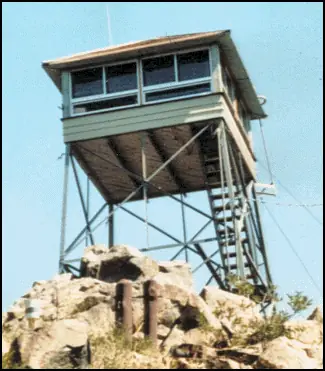
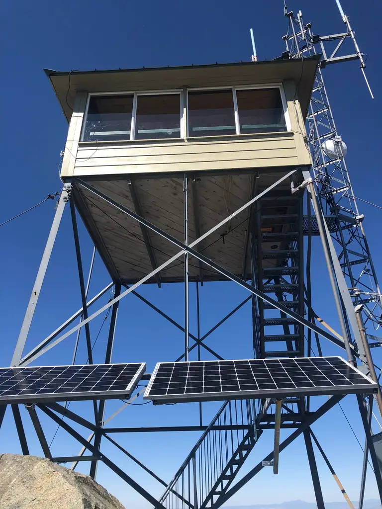
A 1936 Aermotor lookout in the Bradshaw Mountains above Prescott, staffed by a volunteer in fire season and reached by trail; sources disagree on height and elevation.
- Standing
- Open to the public
- Verified
Visit & stay
Not rentable. As far as we know, this lookout cannot be booked for overnight stays.
Access
Open to the public. A rough road reaches the summit, but most people hike the Groom Creek Trail. A Forest Service page says the Spruce Mountain picnic site sits behind a gate that is locked when the tower is not staffed.
- Can you climb it?
- Yes
- Road to the top?
- Yes, you can drive up
- Trail
- Groom Creek Trail to a fire road (about two hours by the blog's account), then about a quarter mile to the summit. Visitors are encouraged to climb while the volunteer is on duty (blog, undated).
- Staffing
- Unknown
Facts
- Status
- Type
- Cab on a towerModified L-4 cab on a 30 ft Aermotor MC-24 tower (register)Cab: L-4; tower: Aermotor MC-24
- Built of
- SteelGoing by its design; no source says so in words.
- Built
- 1921
- Height
- 30 ft (9.1 m)
- Elevation
- 7,633 ft (2,327 m)
- Agency
- U.S. Forest Service
- Land
- Federal land
- Location
- Yavapai County, Arizona
- Coordinates
- 34.46223, −112.40352
- Registers
- This entry
- VerifiedResearched, then checked independently. Updated 8 Oct 2026.
- Firefinder id
us-az-spruce-mountain
View from the cab
What you see from the cab: every ridge out to about 93 miles, the named peaks in sight, and other fire lookouts within view, worked out from terrain data in your browser.
Downloads about 3.2 MB of terrain data the first time.
Or see what it could see on the map: the ground in its line of sight.
History
Then and now
- 1911 First staffedFirst used as a daily patrol lookoutSource: westlookouts.weebly.com
- 1921 BuiltTimbers cut for a new tower in June 1921; new lookout station under construction in July 1921Source: westlookouts.weebly.com
- 1921 FireSmall fire believed to be the year's first lightning fire, first reported from the lookout station in July 1921; lookout F.M. Mulkins on dutySource: westlookouts.weebly.com
- 1932 FireLookout Dwight Morris cut down a lightning-struck pine to smother the fireSource: westlookouts.weebly.com
- 1936 BuiltRegister gives construction in 1936; a blog says the CCC built it. Sources do not say whether this replaced the 1921 tower.Sources: nhlr.org, themtsarecalling.com
- 1938 StaffedRanger Turney placed a new lookout; A. Starker Leopold, a University of California forestry student, was the lookoutSource: westlookouts.weebly.com
- 1949 StaffedForest Service reported the fire lookout had been put back on Spruce MountainSource: westlookouts.weebly.com
- No record between 1949 and 2003
- 2003 Added to the National Historic Lookout RegisterRegistered August 5, 2003 as US 531, AZ 53; nominated by Dave LorenzSource: nhlr.org
- TodayStandingIt still stands, as far as our sources know.
Old maps of this spot
USGS topographic maps from the years a lookout stood may show it, often as a small symbol labelled “Lookout”. See the old topo maps around it on the Firefinder map, or find every scanned sheet of this spot on USGS TopoView (opens another site) (click the spot there to list them, with dates and downloads).
Story
Researched 8 Oct 2026, fact-checked.
Spruce Mountain was a fire lookout well before its current tower went up.1 The summit was first used as a daily patrol lookout in 1911, and by June 1921 crews were cutting timbers for a new tower there.1 The tower standing today, the register says, was constructed in 1936 and carries a modified L-4 cab on a 30-foot Aermotor MC-24 tower.2 A hiking blog credits the Civilian Conservation Corps with building it.3 The sources do not say whether the 1936 tower replaced the one planned in 1921.
Newspapers name the lookouts on duty over the years. In July 1921 a small fire, believed to be the year's first lightning fire, was first reported from the station, where lookout F.M. Mulkins was on duty.1 In 1932 lookout Dwight Morris spent a night felling a lightning-struck pine to smother its fire.1 In 1938 a ranger placed a new lookout there, a forestry student from the University of California named A. Starker Leopold.1 A 1949 paper, citing a Forest Service report, said the fire lookout had been put back on the mountain, a wording that hints it had been off duty for a time.1
The register added the tower on August 5, 2003, as US 531, AZ 53, nominated by Dave Lorenz.2 Its own figures disagree: the details list the elevation as 7,633 feet, while the description gives 7,693.2
The register says the lookout "continues in active service."2 A hiking blog says a volunteer staffs the lookout in peak fire season, and that visitors are urged to climb about 55 feet to talk with that person.3 That height does not match the register's 30-foot tower, and none of the sources explains the gap.
Most visitors hike the Groom Creek Trail.3 The blog says a rough road also reaches the top, and that the hike takes about two hours to reach the fire road, then a quarter mile more.3 A Forest Service page notes that the Spruce Mountain picnic site has a gate that stays locked whenever the tower goes unstaffed, so check whether the volunteer is on duty before you set out.4
- Spruce Mountain, Forest Lookouts (westlookouts.weebly.com), https://westlookouts.weebly.com/spruce-mountain1.html (accessed 2026-10-08). ↩
- Spruce Mountain Lookout, National Historic Lookout Register, http://nhlr.org/lookouts/us/az/spruce-mountain-lookout/ (accessed 2026-10-08). ↩
- Spruce Mountain, The Mountains Are Calling (blog), https://themtsarecalling.com/spruce/ (accessed 2026-10-08). ↩
- Bradshaw Ranger District, Prescott National Forest, U.S. Forest Service, https://www.fs.usda.gov/r03/prescott/recreation/bradshaw-ranger-district-0 (accessed 2026-10-08). ↩
Photos

Photos keep their own rights and are shown with credit. Is one of these yours? You can ask for a different credit or for removal.
Sources
- National Historic Lookout Register (NHLR) (opens another site) Gave us: name, location, county, elevation, what it is built of, register numbers, agency, ownership, dates, photos, links National Historic Lookout Register (nhlr.org) · All rights reserved (American Resources, Inc.); facts extracted only, no prose copied. · retrieved 4 Oct 2026
- Forest Fire Lookout Association (FFLA) - US lookout lists (opens another site) Gave us: type, status, register numbers, links Forest Fire Lookout Association (firelookout.org) · No licence stated; facts extracted only, no prose copied. · retrieved 8 Oct 2026
- Wikidata -- US fire lookout towers (Q748998 and subclasses) (opens another site) Gave us: photos, links Wikidata · CC0 1.0 (Wikidata). Images keep their own Commons licence/credit. · retrieved 4 Oct 2026
- OpenStreetMap -- fire lookout structures (opens another site) Gave us: links © OpenStreetMap contributors · ODbL 1.0. (c) OpenStreetMap contributors. · retrieved 4 Oct 2026
- FOREST LOOKOUTS -- western US (Ron Kemnow's weebly sites) (opens another site) Gave us: links Ron Kemnow's Forest Lookouts sites (westlookouts, californialookouts, idaholookouts, montanalookouts, oregonlookouts and washingtonlookouts .weebly.com) · No licence stated; facts only (county, land manager, status word, coordinates where the page's own map widget gives them, township-range-section, height and design hints, links). The site's own newspaper quotes, citations and narrative are not reproduced. · retrieved 8 Oct 2026
- Firefinder research Gave us: summary, design, height, status, agency, access, visiting details, dates, links, fact-check Firefinder research (sources cited in the story footnotes) · Our own research notes; each fact cites its source in the lookout's story
More about this lookout elsewhere
- NHLR register entry US 531 (nhlr.org) (opens another site)
- NHLR register entry (nhlr.org) (opens another site)
- Spruce Mountain (The Mountains Are Calling (blog)) (opens another site)
- Bradshaw Ranger District (Prescott National Forest, U.S. Forest Service) (opens another site)
- FFLA Arizona lookout list (firelookout.org) (opens another site)
- Spruce Mountain on Forest Lookouts, western US (Ron Kemnow) (opens another site)
- Wikidata item Q86927138 (opens another site)
- OpenStreetMap node 5646815516 (opens another site)
Firefinder takes facts (places, dates, numbers) from these sources and writes its own words. See all sources and licences.