Fire lookout · Graham County, Arizona
Webb Peak Lookout
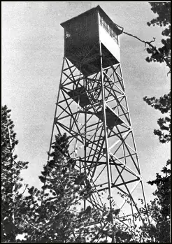
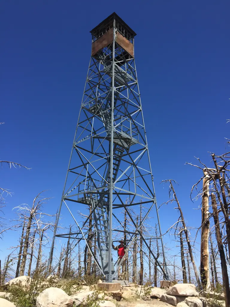
A 1933 Aermotor fire tower in the Pinaleno Mountains, inactive since the 2017 Frye Fire; sources disagree on whether the tower survived.
- Standing
- Access unknown
- Verified
Visit & stay
Not rentable. As far as we know, this lookout cannot be booked for overnight stays.
Access
Access unknown
We do not know the access rules. Check with the land manager before you go.
- Can you climb it?
- Unknown
- Road to the top?
- Unknown
- Trail
- Trail head sign at Columbine Campground; the trail is hard to follow in places because of fallen timber and erosion
- Staffing
- Not staffed (as of 2020)
Facts
- Status
- Type
- Cab on a tower46-foot Aermotor tower with a 7x7-foot metal cab (register: MC-40; hiking club: CL 100-106)The design: Aermotor
- Built of
- SteelGoing by its design; no source says so in words.
- Built
- 1933
- Height
- 45 ft (13.7 m)
- Elevation
- 9,984 ft (3,043 m)
- Agency
- U.S. Forest Service
- Land
- Federal land
- Location
- Graham County, Arizona
- Coordinates
- 32.71093, −109.92310
- Registers
- This entry
- VerifiedResearched, then checked independently. Updated 8 Oct 2026.
- Firefinder id
us-az-webb-peak
View from the cab
What you see from the cab: every ridge out to about 93 miles, the named peaks in sight, and other fire lookouts within view, worked out from terrain data in your browser.
Downloads about 3.0 MB of terrain data the first time.
Or see what it could see on the map: the ground in its line of sight.
History
Then and now
- 1933 BuiltRegister gives 1933; NRHP record lists the CCC as architectSources: nhlr.org, gvrhc.org, npgallery.nps.gov
- No record between 1933 and 1988
- 1988 Listed on the National Register of Historic PlacesListed January 28, 1988 (NPGallery date published); also described on the Weebly siteSources: npgallery.nps.gov, westlookouts.weebly.com
- No record between 1988 and 2003
- 2003 Added to the National Historic Lookout RegisterRegistered January 31, 2003; nominated by Dave LorenzSource: nhlr.org
- 2017 FireFrye Fire, begun by lightning on June 7, 2017; support structures destroyed. Sources disagree on whether the tower was destroyed.Sources: en.wikipedia.org, gvrhc.org, westlookouts.weebly.com
- TodayStandingIt still stands, as far as our sources know.
Old maps of this spot
USGS topographic maps from the years a lookout stood may show it, often as a small symbol labelled “Lookout”. See the old topo maps around it on the Firefinder map, or find every scanned sheet of this spot on USGS TopoView (opens another site) (click the spot there to list them, with dates and downloads).
Story
Researched 8 Oct 2026, fact-checked.
Webb Peak Lookout sits on Webb Peak in the Pinaleno Mountains of Graham County, Arizona, inside the Coronado National Forest.1,2 The National Register record lists the Civilian Conservation Corps as its architect and gives 1933 as the significant year.3 The tower is a 46-foot Aermotor with a 7-by-7-foot metal cab.1,2 The register notes that the original platform ladder was converted, so only the last section is now a ladder climb.1 The two sources name different Aermotor models, the register's MC-40 and the hiking club's CL 100-106, and they also disagree on elevation: 9,984 feet in the register and 10,029 feet in the hiking club's report.1,2
The lookout was listed on the National Register of Historic Places in 1988, and it entered the National Historic Lookout Register on January 31, 2003.3,1 The register now calls it inactive.1 Its visit report from May 2020 records the lookout as not staffed, finds the steel frame in good condition, and leaves the cab at the top uncertain.1
A lightning strike on Mount Graham started the Frye Fire in June 2017, and the fire burned 48,443 acres in Graham County.4 The register's 2020 visit found that the fire had cooked the lookout and left it surrounded by charred timber.1 The hiking club reports that the fire destroyed the support structures, while the metal tower and cab were still standing afterward.2 A Weebly lookout site says instead that the tower was caught in the blaze and destroyed.5 The sources disagree on the tower's fate. I give the most weight to the 2020 register visit and the hiking club's report, since both describe the steel frame still standing.1,2
Getting to it means a hike. The register notes a trailhead sign at Columbine Campground, but the trail to the tower is hard to follow in places because of fallen timber and erosion.1 I found no mention of overnight rental or a visitor program in these sources. With the cab's condition uncertain, it is best admired from the ground.1,2
- Webb Peak Lookout, National Historic Lookout Register (nhlr.org), http://nhlr.org/lookouts/us/az/webb-peak-lookout/ (accessed 2026-10-08). ↩
- Webb Peak Fire Lookout, GVRHC, https://www.gvrhc.org/Library/WebbPeakFireLookout.pdf (accessed 2026-10-08). ↩
- Webb Peak Lookout Tower, National Register Information System, National Park Service, https://npgallery.nps.gov/AssetDetail/NRIS/87002464 (accessed 2026-10-08). ↩
- Frye Fire, Wikipedia, https://en.wikipedia.org/wiki/Frye_Fire (accessed 2026-10-08). ↩
- Webb Peak, FOREST LOOKOUTS, https://westlookouts.weebly.com/webb-peak.html (accessed 2026-10-08). ↩
Photos
Photos keep their own rights and are shown with credit. Is one of these yours? You can ask for a different credit or for removal.
Sources
- National Historic Lookout Register (NHLR) (opens another site) Gave us: name, location, county, elevation, what it is built of, register numbers, agency, ownership, dates, photos, links National Historic Lookout Register (nhlr.org) · All rights reserved (American Resources, Inc.); facts extracted only, no prose copied. · retrieved 4 Oct 2026
- Forest Fire Lookout Association (FFLA) - US lookout lists (opens another site) Gave us: type, status, register numbers, links Forest Fire Lookout Association (firelookout.org) · No licence stated; facts extracted only, no prose copied. · retrieved 8 Oct 2026
- Wikidata -- US fire lookout towers (Q748998 and subclasses) (opens another site) Gave us: height, register numbers, dates, links Wikidata · CC0 1.0 (Wikidata). Images keep their own Commons licence/credit. · retrieved 4 Oct 2026
- OpenStreetMap -- fire lookout structures (opens another site) Gave us: links © OpenStreetMap contributors · ODbL 1.0. (c) OpenStreetMap contributors. · retrieved 4 Oct 2026
- FOREST LOOKOUTS -- western US (Ron Kemnow's weebly sites) (opens another site) Gave us: links Ron Kemnow's Forest Lookouts sites (westlookouts, californialookouts, idaholookouts, montanalookouts, oregonlookouts and washingtonlookouts .weebly.com) · No licence stated; facts only (county, land manager, status word, coordinates where the page's own map widget gives them, township-range-section, height and design hints, links). The site's own newspaper quotes, citations and narrative are not reproduced. · retrieved 8 Oct 2026
- Firefinder research Gave us: summary, design, agency, staffing, visiting details, dates, links, fact-check Firefinder research (sources cited in the story footnotes) · Our own research notes; each fact cites its source in the lookout's story
More about this lookout elsewhere
- NHLR register entry US 451 (nhlr.org) (opens another site)
- NHLR register entry (nhlr.org) (opens another site)
- Webb Peak Fire Lookout (PDF) (GVRHC (gvrhc.org)) (opens another site)
- Webb Peak Lookout Tower, NRIS 87002464 (National Register Information System, National Park Service (NPGallery)) (opens another site)
- Frye Fire (Wikipedia) (opens another site)
- FFLA Arizona lookout list (firelookout.org) (opens another site)
- Webb Peak on Forest Lookouts, western US (Ron Kemnow) (opens another site)
- Wikidata item Q86928389 (opens another site)
- OpenStreetMap way 281970799 (opens another site)
Firefinder takes facts (places, dates, numbers) from these sources and writes its own words. See all sources and licences.