Fire lookout · Mendocino County, California
Anthony Peak Lookout
L-4 pyramid-roof lookout in Mendocino National Forest; build year 1932 or 1934 by source; condemned 1990, restored 1993; staffed May to October in 2026.
- Standing
- Access unknown
- Verified
Visit & stay
Not rentable. As far as we know, this lookout cannot be booked for overnight stays.
Access
Access unknown
We do not know the access rules. Check with the land manager before you go.
- Can you climb it?
- Unknown
- Road to the top?
- Unknown
- Staffing
- Unknown
Facts
- Status
- Type
- Enclosed towerL-4 pyramid roof design; wooden 14 by 14 foot live-in cab with catwalk on a 10 foot wood towerThe design: L-4
- Built of
- Wood
- Also served as
- Aircraft Warning Service postDuring the Second World War it was staffed to spot and report aircraft.
- Built
- 1932
- Height
- 29 ft (8.8 m)
- Elevation
- 6,891 ft (2,100 m)
- Agency
- U.S. Forest Service
- Land
- Federal land
- Location
- Mendocino County, California
- Coordinates
- 39.84616, −122.96454
- Registers
- This entry
- VerifiedResearched, then checked independently. Updated 8 Oct 2026.
- Firefinder id
us-ca-anthony-peak
View from the cab
What you see from the cab: every ridge out to about 93 miles, the named peaks in sight, and other fire lookouts within view, worked out from terrain data in your browser.
Downloads about 3.5 MB of terrain data the first time.
Or see what it could see on the map: the ground in its line of sight.
History
Then and now
- 1932 BuiltRegister gives 1932; a local history gives 1934 (see resolved_conflicts)Source: nhlr.org
- 1934 BuiltForest Lookouts page says the CCC constructed it in 1934; a 1994 Ukiah Daily Journal item says the California Conservation Corps built itSource: californialookouts.weebly.com
- 1940 StaffedA July 19, 1940 item names Ralph McCombs as having charge of the lookout stationSource: californialookouts.weebly.com
- 1941 AlteredTower enclosed for year-long staffing as an enemy aircraft warning station during World War IISource: nhlr.org
- 1946 StaffedMay 29, 1946 item: a lookout established on Anthony Peak with a Covelo man in chargeSource: californialookouts.weebly.com
- 1956 StaffedJune 21, 1956 item: manned for fire detection; equipment packed in the last mile past a snowdriftSource: californialookouts.weebly.com
- No record between 1956 and 1990
- 1990 ClosedFound unsafe and condemned after continuous use until thenSource: californialookouts.weebly.com
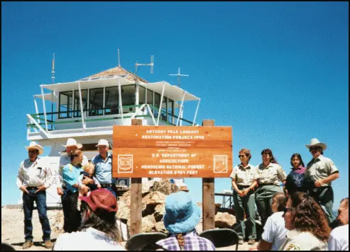
- 1993 RestoredRehabilitated to its original configuration by the Forest Service and volunteers (Forest Lookouts); the Register credits the Forest Service and the Twin Rocks Landowners Association with the restorationSources: nhlr.org, californialookouts.weebly.com
- 1994 Added to the National Historic Lookout RegisterRegistered September 16, 1994 as US 88, CA 2Source: nhlr.org
- 1994 EventJuly 1994: Covelo Ranger District announced a dedication ceremony to reopen the lookoutSource: californialookouts.weebly.com
- No record between 1994 and 2012
- 2012 FireNorth Pass Fire (about 42,000 acres, much of it on the Covelo Ranger District); building wrapped in foil for protection (September 4, 2012 item)Source: californialookouts.weebly.com
- 2026 StaffedArticle says staffed each year from May to OctoberSource: kymkemp.com
- TodayStandingIt still stands, as far as our sources know.
Old maps of this spot
USGS topographic maps from the years a lookout stood may show it, often as a small symbol labelled “Lookout”. See the old topo maps around it on the Firefinder map, or find every scanned sheet of this spot on USGS TopoView (opens another site) (click the spot there to list them, with dates and downloads).
Story
Researched 8 Oct 2026, fact-checked.
Anthony Peak Lookout stands in the Mendocino National Forest, in Mendocino County, California, at about 2,100 meters.1 Its build year is disputed.1,2 The National Historic Lookout Register gives 1932,1 but a Forest Lookouts history says the CCC built it in 1934 and quotes a 1994 Ukiah newspaper that names the California Conservation Corps.2
The Register describes an L-4 pyramid roof design, with a wooden live-in cab and catwalk on a wood tower.1 The tower was enclosed in 1941 so that it could be staffed all year as a station that warned of enemy aircraft during World War II.1
The sources read give only scattered staffing notes. A 1940 item names Ralph McCombs as in charge of the station, and a 1946 item says a lookout was established with Bob Pinkerton, of Covelo, in charge.2 A 1956 item says equipment had to be carried the last mile on people's backs because a snowdrift blocked the truck.2 In 2012 the North Pass Fire burned about 42,000 acres, much of it on the Covelo Ranger District, and precautions were taken to protect the lookout by wrapping the building in foil.2
The lookout was found unsafe and condemned in 1990, after it had been used continuously until then.2 The Forest Service and volunteers rehabilitated it in 1993.2 The Register credits the restoration to the Forest Service and the Twin Rocks Landowners Association, and it accepted the lookout on September 16, 1994, as US 88, CA 2.1 In July 1994 the Covelo Ranger District announced a dedication ceremony to reopen it.2
Today, a 2026 article about the rebuilt High Glade lookout says Anthony Peak is one of three lookouts left on the Mendocino National Forest and that it is staffed each year from May to October.3 The sources read do not say whether visitors may climb the tower, and none lists it as a rental. Anyone planning a trip should check with the Mendocino National Forest first.
- Anthony Peak Lookout, National Historic Lookout Register (nhlr.org), http://nhlr.org/lookouts/us/ca/anthony-peak-lookout/ (accessed 2026-10-08). ↩
- Anthony Peak - FOREST LOOKOUTS, Forest Lookouts (californialookouts.weebly.com), https://californialookouts.weebly.com/anthony-peak.html (accessed 2026-10-08). ↩
- High Glade Lookout rebuilt and ready for fire duty, kymkemp.com, https://kymkemp.com/2026/08/29/high-glade-lookout-rebuilt-and-ready-for-fire-duty/ (accessed 2026-10-08). ↩
Photos
Photos keep their own rights and are shown with credit. Is one of these yours? You can ask for a different credit or for removal.
Sources
- National Historic Lookout Register (NHLR) (opens another site) Gave us: name, location, county, elevation, what it is built of, wartime use, register numbers, agency, ownership, dates, photos, links National Historic Lookout Register (nhlr.org) · All rights reserved (American Resources, Inc.); facts extracted only, no prose copied. · retrieved 4 Oct 2026
- Forest Fire Lookout Association (FFLA) - US lookout lists (opens another site) Gave us: type, status, register numbers, links Forest Fire Lookout Association (firelookout.org) · No licence stated; facts extracted only, no prose copied. · retrieved 8 Oct 2026
- OpenStreetMap -- fire lookout structures (opens another site) Gave us: links © OpenStreetMap contributors · ODbL 1.0. (c) OpenStreetMap contributors. · retrieved 4 Oct 2026
- FOREST LOOKOUTS -- western US (Ron Kemnow's weebly sites) (opens another site) Gave us: height, links Ron Kemnow's Forest Lookouts sites (westlookouts, californialookouts, idaholookouts, montanalookouts, oregonlookouts and washingtonlookouts .weebly.com) · No licence stated; facts only (county, land manager, status word, coordinates where the page's own map widget gives them, township-range-section, height and design hints, links). The site's own newspaper quotes, citations and narrative are not reproduced. · retrieved 8 Oct 2026
- Firefinder research Gave us: summary, design, status, agency, dates, links, fact-check Firefinder research (sources cited in the story footnotes) · Our own research notes; each fact cites its source in the lookout's story
More about this lookout elsewhere
- NHLR register entry US 88 (nhlr.org) (opens another site)
- NHLR register entry (nhlr.org) (opens another site)
- High Glade Lookout rebuilt and ready for fire duty (kymkemp.com) (opens another site)
- FFLA California lookout list (firelookout.org) (opens another site)
- Anthony Peak on Forest Lookouts, western US (Ron Kemnow) (opens another site)
- OpenStreetMap way 1188777968 (opens another site)
Firefinder takes facts (places, dates, numbers) from these sources and writes its own words. See all sources and licences.