Fire lookout · Siskiyou County, California
Black Butte Lookout Site (Shasta-Trinity National Forest)
Also known as Black Butte
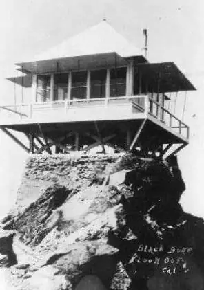
Summit lookout on Black Butte: station due for dedication 1931, wrecked in the 1962 storm, rebuilt 1963, moved off by 1975-77; only a concrete foundation remains.
- Gone
- Open to the public
- Verified
Gone: The lookout no longer stands. Only the site is left. The cabin was moved off the summit; only a concrete foundation remains at the summit (Forest Service sheet).
Visit & stay
Gone: site only. The lookout no longer stands, so there is nothing to climb or rent. You may still be able to visit the site.
Access
Open to the public. Reached on foot by a trail from a trailhead off a gravel road.
- Road to the top?
- No, you have to hike
- Trail
- About 2.56 miles from the trailhead to the summit, about 1,845 feet of climb, no water on the trail; the Forest Service maintains it each year.
Facts
- Status
- Type
- Ground-level cabC-16 all-steel cabin (FFLOS); the replacement was specified on a concrete block base (clippings)The design: D-5 (4-AR)
- Built of
- Steel
- Built
- 1931
- Height
- 13 ft (4.0 m)
- Elevation
- 6,337 ft (1,932 m)
- Agency
- US Forest Service - Shasta-Trinity National Forest
- Land
- Federal land
- Location
- Siskiyou County, California
- Coordinates
- 41.36654, −122.34812 sources disagree
- Registers
- This entry
- VerifiedResearched, then checked independently. Updated 9 Oct 2026.
- Firefinder id
us-ca-black-butte-shasta-trinity-national-forest
View from the cab
What the lookout saw from its cab: every ridge out to about 93 miles, the named peaks in sight, and other fire lookouts within view, worked out from terrain data in your browser.
This lookout is gone. The view is reconstructed from its recorded site and its recorded height.
Downloads about 3.5 MB of terrain data the first time.
Or see what it could see on the map: the ground in its line of sight.
History
Then and now
- 1931 BuiltLookout station on the summit due for dedication October 1931; the trail to it dedicated that month (clippings). Building type not stated.Source: californialookouts.weebly.com
- 1939 FireLookout spotted a house fire in south Dunsmuir and raised the alarm; the house was destroyed.Source: californialookouts.weebly.com
- 1943 StaffedFrank Jackson, Forest Service look-out on Black Butte (clipping dated October 22, 1943; again in a July 7, 1944 item).Source: californialookouts.weebly.com
- No record between 1943 and 1961
- 1961 StaffedCecelia Thompson of Dunsmuir took the job; second season in 1962.Source: californialookouts.weebly.com
- 1962 DestroyedColumbus Day storm, October 1962. Sources differ on which building was lost.Sources: firetower.org, californialookouts.weebly.com, fs.usda.gov
- 1963 Built'Built' field on FFLOS detail pageSource: FFLOS register entry
- 1963 RebuiltMetal cabin rebuilt after the storm, materials lifted by helicopter; Mildred Weston moved in summer 1963.Sources: firetower.org, californialookouts.weebly.com, fs.usda.gov
- 1973 Last staffedForest Service sheet: the lookout operated until 1973.Source: fs.usda.gov
- 1975 MovedForest Service sheet: the building was moved by helicopter to a new location.Source: fs.usda.gov
- 1977 RemovedFFLOS gives 1977 for removal, with relocation to Hogback Mountain that year.Source: firetower.org
- No record between 1977 and 2020
- 2020 Added to the Former Fire Lookout Sites RegisterDate registered per FFLOS detail page: April 15, 2020Source: FFLOS register entry
- TodayGoneThe lookout no longer stands. Only the site is left.
Old maps of this spot
USGS topographic maps from the years a lookout stood may show it, often as a small symbol labelled “Lookout”. See the old topo maps around it on the Firefinder map, or find every scanned sheet of this spot on USGS TopoView (opens another site) (click the spot there to list them, with dates and downloads).
Story
Researched 9 Oct 2026, fact-checked.
A lookout station on the summit of Black Butte, near Mount Shasta, was due for dedication in October 1931, and the clippings report that the trail up to it was dedicated that month.1 A Forest Service sheet gives a different start for the trail, saying the Civilian Conservation Corps built it in the late 1930s.2
Forest Service lookouts staffed the station through the 1940s and into the 1960s.1 Frank Jackson was on duty in the 1940s, and in May 1939 the lookout spotted a house fire in south Dunsmuir and raised the alarm, though the house was destroyed.1 Cecelia Thompson, of Dunsmuir, took the job in 1961 and came back for a second season in 1962.1
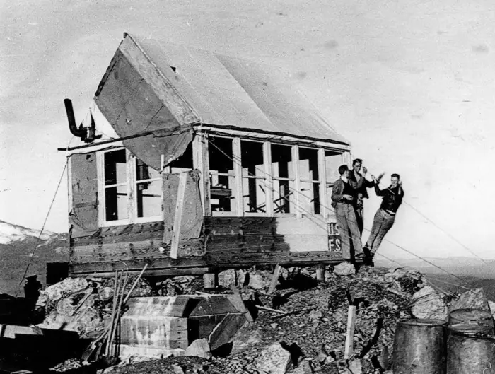
The Columbus Day storm of October 1962 wrecked the station.1,2 The sources disagree about what it took. FFLOS says a Plan 4AR ground cabin was blown off the mountain that year.3 The newspaper clippings say the original building, which dated from 1931, blew away.1
The Forest Service rebuilt the station in 1963 as a metal cabin, and the materials went up by helicopter.1,2 FFLOS describes that cabin as a C-16 all-steel cabin.3 Mildred Weston moved into the new lookout in the summer of 1963.1
The Forest Service says the cabin operated until 1973 and was moved by helicopter to a new location in 1975.2 FFLOS dates the move to Hogback Mountain to 1977, and an undated clipping also places the cabin on Hogback Mountain.3,1 The sources do not agree on the year.
Today only a concrete foundation is left at the summit, according to the Forest Service.2 The summit is reached on foot. The trail runs about 2.56 miles from a trailhead off a gravel road, climbs about 1,845 feet, and has no water along the way.2 The Forest Service keeps the trail up every year, but its surface is rocky, and some stretches are steep.2
- Black Butte, Forest Lookouts (California) clippings, californialookouts.weebly.com, https://californialookouts.weebly.com/black-butte1.html (accessed 2026-10-09). ↩
- Black Butte Trail, Mt. Shasta and McCloud Ranger Stations, USDA Forest Service Shasta-Trinity National Forest, https://www.fs.usda.gov/sites/nfs/files/legacy-media/shasta-trinity/Black%20Butte%20Trail%20ROG.pdf (accessed 2026-10-09). ↩
- Black Butte Lookout Site (Shasta-Trinity National Forest), Former Fire Lookout Sites, http://firetower.org/lookouts/us/ca/black-butte-lookout-site-shasta-trinity-national-forest/ (accessed 2026-10-09). ↩
Photos
Photos keep their own rights and are shown with credit. Is one of these yours? You can ask for a different credit or for removal.
Where sources disagree
We show disagreements between sources instead of quietly picking one. If you know which is right, please tell us.
Sources disagree on the location by 3.3 km (2.1 mi).
- FFLOS: 41.36654, −122.34812
- FOREST LOOKOUTS -- western US (Ron Kemnow's weebly sites): 41.39348, −122.36486
The map uses the position from FFLOS.
Sources
- Former Fire Lookout Sites Register (FFLOS) (opens another site) Gave us: name, location, county, elevation, what it is built of, register numbers, agency, ownership, dates, photos, links Former Fire Lookout Sites Register (firetower.org) · All rights reserved (American Resources, Inc.); facts extracted only, no prose copied. · retrieved 4 Oct 2026
- Forest Fire Lookout Association (FFLA) - US lookout lists (opens another site) Gave us: type, status, register numbers, links Forest Fire Lookout Association (firelookout.org) · No licence stated; facts extracted only, no prose copied. · retrieved 8 Oct 2026
- FOREST LOOKOUTS -- western US (Ron Kemnow's weebly sites) (opens another site) Gave us: height Ron Kemnow's Forest Lookouts sites (westlookouts, californialookouts, idaholookouts, montanalookouts, oregonlookouts and washingtonlookouts .weebly.com) · No licence stated; facts only (county, land manager, status word, coordinates where the page's own map widget gives them, township-range-section, height and design hints, links). The site's own newspaper quotes, citations and narrative are not reproduced. · retrieved 8 Oct 2026
- Firefinder research Gave us: summary, design, status, agency, access, visiting details, dates, links, fact-check Firefinder research (sources cited in the story footnotes) · Our own research notes; each fact cites its source in the lookout's story
More about this lookout elsewhere
- FFLOS register entry US 2008 (firetower.org) (opens another site)
- Black Butte Trail (USDA Forest Service, Shasta-Trinity National Forest) (opens another site)
- FFLA California lookout list (firelookout.org) (opens another site)
- Black Butte Lookout - Forest Lookouts Page (opens another site)
Firefinder takes facts (places, dates, numbers) from these sources and writes its own words. See all sources and licences.