Fire lookout · Tulare County, California
Buck Rock Lookout
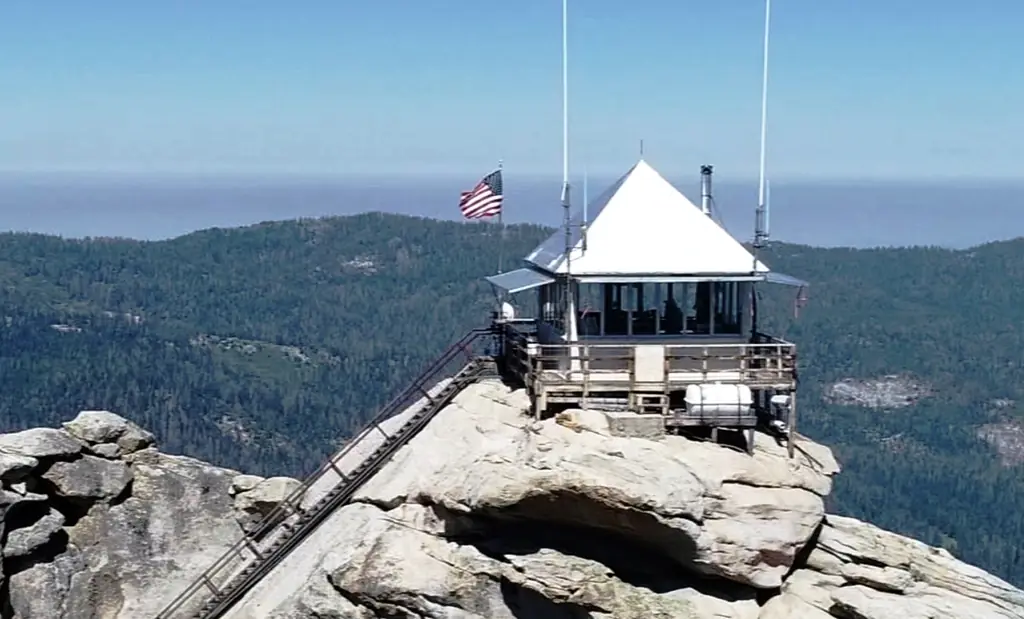
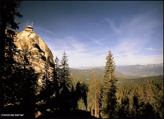
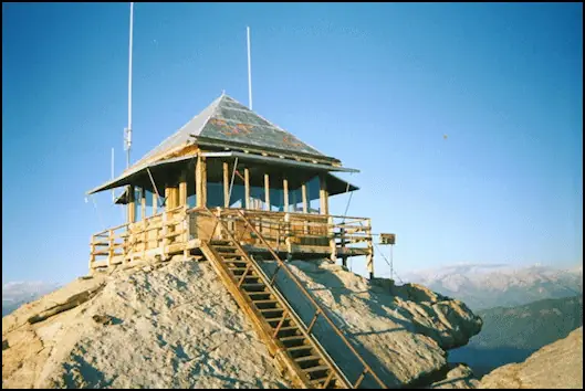
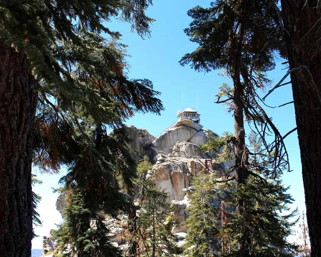
Active 1923 4A-style lookout on a granite dome in Sequoia National Forest, still staffed in fire season and open to climbing visitors.
- Standing
- Open to the public
- Verified
Visit & stay
Not rentable. As far as we know, this lookout cannot be booked for overnight stays.
Access
Open to the public. Staffed full-time in fire season and open to visitors who climb the stairs; one of the most-visited lookout sites in the Giant Sequoia National Monument.
- Can you climb it?
- Yes
- Road to the top?
- No, you have to hike
- Trail
- Reached by trail/road to the base and then a suspended staircase up the granite dome; south of Hume Lake in the Hume Lake Ranger District.
- Staffing
- Staffed during fire season (as of 2026)
Facts
- Status
- Type
- Ground-level cab4A style, 14 by 14 ft cab (1917-1923 design), replaced on-site by the 4AR model elsewhere; reached via a suspended flight of stairsThe designs: Plan 4-A, D-5 (4-AR)
- Built of
- WoodGoing by its design; no source says so in words.
- Built
- 1917
- Height
- 8,408 ft (2562.8 m)
- Elevation
- 8,408 ft (2,563 m)
- Agency
- U.S. Forest Service
- Land
- Federal land
- Location
- Tulare County, California
- Coordinates
- 36.73600, −118.85976 sources disagree
- Registers
- This entry
- VerifiedResearched, then checked independently. Updated 8 Oct 2026.
- Firefinder id
us-ca-buck-rock
View from the cab
What you see from the cab: every ridge out to about 93 miles, the named peaks in sight, and other fire lookouts within view, worked out from terrain data in your browser.
Downloads about 3.2 MB of terrain data the first time.
Or see what it could see on the map: the ground in its line of sight.
History
Then and now
- 1912 First staffedBuck Rock established as a key fire-detection location circa 1912.Source: fire-lookouts.org
- 1917 Built4A-style 14x14 ft lookout design in use from 1917.Source: nhlr.org
- 1923 Built'Built' field on NHLR detail pageSource: NHLR register entry
- 1923 RebuiltCurrent cab built in 1923, when the 4A design was being replaced generally by the newer 4AR model; this is one of only three surviving 4A cabs.Sources: nhlr.org, fire-lookouts.org
- No record between 1923 and 1987
- 1987 ClosedShut and left to decay until 1998, used only in emergencies.Source: buckrock.org
- 1997 EventReopened briefly to track a thunderstorm; the lookout spotted the Choke Fire, and the busy six weeks led locals to form the Buck Rock Foundation.Source: buckrock.org
- 1998 Added to the National Historic Lookout RegisterAdded to the National Historic Lookout Register August 20, 1998.Source: nhlr.org
- 2000 StaffedThe Foundation and the Forest Service reopened it for good after raising grants and volunteers.Source: buckrock.org
- 2007 RestoredWinter-damaged catwalk gates repaired, shed roof replaced, stairway linseed oiled, picnic table refurbished and door frame replaced.Source: firelookout.org
- 2009 RestoredVolunteers rehabilitated parts of the road and trail in and scraped and painted two storage outbuildings at the base.Sources: firelookout.org, firelookout.org
- 2011 EventKern and Tulare Counties RAC grant of about $29,000 for interior makeover and stairway and catwalk work, to start summer 2012.Sources: firelookout.org, firelookout.org
- 2012 RestoredVolunteer and contractor rehab restored original interior and exterior siding, rehabbed windows, upgraded electrical system and replaced a stairway section; funded by a Kern and Tulare RAC grant.Source: firelookout.org
- 2025 RestoredFacility team began repainting the cab exterior, fitted a new stove, strengthened the top stair platform and put in a new water pump.Source: buckrock.org
- TodayStandingIt still stands, as far as our sources know.
Old maps of this spot
USGS topographic maps from the years a lookout stood may show it, often as a small symbol labelled “Lookout”. See the old topo maps around it on the Firefinder map, or find every scanned sheet of this spot on USGS TopoView (opens another site) (click the spot there to list them, with dates and downloads).
Story
Researched 4 Oct 2026, fact-checked.
Buck Rock Lookout sits on a granite dome in the Sequoia National Forest's Hume Lake Ranger District, south of Hume Lake and just north of Kings Canyon and Sequoia National Parks.1 A lookout has stood here since around 1912, making the site one of the earliest fire-detection points in the area.1 The Forest Service originally used a "4A" style 14-by-14-foot cab design from 1917 to 1923, when it was upgraded to the newer "4AR" model.2 The current cab at Buck Rock dates to that 1923 rebuild, and it is one of only three surviving examples of the older 4A style still standing anywhere.2 Reaching the cab means climbing a suspended flight of stairs bolted to the rock itself.2
Because of its age, Buck Rock is now the oldest standing lookout cab in the Sequoia National Forest.1 Its position gives it some of the best views in the district, overlooking Kings Canyon and Sequoia National Parks as well as most of the Hume Lake area, and that combination of easy access and scenery has made it one of the most-visited lookout sites in the Giant Sequoia National Monument.1
Unlike many fire lookouts that were decommissioned decades ago, Buck Rock has stayed in active service. It is staffed full-time during fire season and, notably, remains open to the public at the same time — visitors can climb the stairs and talk with the lookout on duty rather than just view the tower from below.1 The Buck Rock Foundation, a volunteer nonprofit, supports the lookout's historic preservation and runs public education about fire lookouts and fire management, and also operates a webcam showing current conditions at the site.3 The lookout was added to the National Historic Lookout Register in 1998.2
Access today is by trail within the national forest, and the stairway climb itself requires a head for heights. Because the lookout is both a working fire station and a historic structure, visitors should check current conditions and any closures with the Hume Lake Ranger District or the Buck Rock Foundation before planning a climb.
- Buck Rock Lookout, fire-lookouts.org (Sequoia National Forest lookout history pages), https://www.fire-lookouts.org/cali/buck_rock/index.htm (accessed 2026-10-04). ↩
- Buck Rock Lookout, National Historic Lookout Register, http://nhlr.org/lookouts/us/ca/buck-rock-lookout/ (accessed 2026-10-04). ↩
- Buck Rock Foundation, https://buckrock.org/ (accessed 2026-10-04). ↩
Photos

Photos keep their own rights and are shown with credit. Is one of these yours? You can ask for a different credit or for removal.
Where sources disagree
We show disagreements between sources instead of quietly picking one. If you know which is right, please tell us.
Sources disagree on the location by 530 m.
- NHLR: 36.73600, −118.85976
- California Fire Lookouts of the Sierra National Forest and Other Areas (fire-lookouts.org): 36.73173, −118.86246
They share a register number.
The map uses the position from NHLR.
Sources
- National Historic Lookout Register (NHLR) (opens another site) Gave us: name, location, county, elevation, register numbers, agency, dates, photos, links National Historic Lookout Register (nhlr.org) · All rights reserved (American Resources, Inc.); facts extracted only, no prose copied. · retrieved 4 Oct 2026
- Forest Fire Lookout Association (FFLA) - US lookout lists (opens another site) Gave us: type, status, register numbers, links Forest Fire Lookout Association (firelookout.org) · No licence stated; facts extracted only, no prose copied. · retrieved 8 Oct 2026
- Recreation Information Database (recreation.gov) (opens another site) Gave us: ownership, access Data source: ridb.recreation.gov · Public data from the US government · retrieved 19 Oct 2026
- California Fire Lookouts of the Sierra National Forest and Other Areas (fire-lookouts.org) (opens another site) Gave us: register numbers, staffing, photos, links fire-lookouts.org · Public information per the site's disclaimer, credit requested. Facts + a short description reused under that permission -- see extra.license per record. · retrieved 4 Oct 2026
- Buck Rock Foundation (opens another site) Gave us: what it is built of, design, dates, links Buck Rock Foundation (buckrock.org) · No licence stated; facts only (dates, names, the kind of work done). Every note is our own wording and every event links to the foundation's page it comes from. Positions are copied from the NHLR records. · retrieved 8 Oct 2026
- Forest Fire Lookout Association chapter reports (opens another site) Gave us: dates, links Forest Fire Lookout Association, chapter and restoration-grant reports (firelookout.org) · No licence stated; facts only (dates, names, the kind of work done). Every note is our own wording and every event links to the FFLA report it comes from. Positions are copied from the NHLR, FFLOS and FFLA records. · retrieved 8 Oct 2026
- Wikidata -- US fire lookout towers (Q748998 and subclasses) (opens another site) Gave us: photos, links Wikidata · CC0 1.0 (Wikidata). Images keep their own Commons licence/credit. · retrieved 4 Oct 2026
- OpenStreetMap -- fire lookout structures (opens another site) Gave us: links © OpenStreetMap contributors · ODbL 1.0. (c) OpenStreetMap contributors. · retrieved 4 Oct 2026
- FOREST LOOKOUTS -- western US (Ron Kemnow's weebly sites) (opens another site) Gave us: links Ron Kemnow's Forest Lookouts sites (westlookouts, californialookouts, idaholookouts, montanalookouts, oregonlookouts and washingtonlookouts .weebly.com) · No licence stated; facts only (county, land manager, status word, coordinates where the page's own map widget gives them, township-range-section, height and design hints, links). The site's own newspaper quotes, citations and narrative are not reproduced. · retrieved 8 Oct 2026
- FFLA chapters, affiliates and Friends groups: lookout pages (opens another site) Gave us: links FFLA chapters and Friends groups (each link names the group) · Links to the groups' own pages; facts only from the California-South chapter's tower table (register page, operator, condition). No text or photos reproduced. · retrieved 8 Oct 2026
- Firefinder research Gave us: summary, design, height, status, agency, access, staffing, visiting details, dates, links, fact-check Firefinder research (sources cited in the story footnotes) · Our own research notes; each fact cites its source in the lookout's story
More about this lookout elsewhere
- NHLR register entry US 284 (nhlr.org) (opens another site)
- NHLR register entry (nhlr.org) (opens another site)
- FFLA California lookout list (firelookout.org) (opens another site)
- Buck Rock Foundation: work on Buck Rock Lookout (opens another site)
- Forest Fire Lookout Association chapter reports: work on Buck Rock Lookout (opens another site)
- Buck Rock lookout: Buck Rock Foundation (opens another site)
- Buck Rock Fire Lookout on fire-lookouts.org (Rich Camp) (opens another site)
- Buck Rock on Forest Lookouts, western US (Ron Kemnow) (opens another site)
- Website (buckrock.org) (opens another site)
- Wikidata item Q86927848 (opens another site)
- OpenStreetMap way 1293676447 (opens another site)
Firefinder takes facts (places, dates, numbers) from these sources and writes its own words. See all sources and licences.