Fire lookout · Shasta County, California
Burney Mountain Lookout
A 1930s lookout on Burney Mountain in Shasta County; the 1966 block-and-steel cab is reported in use, though sources disagree on the dates.
- Standing
- Restricted access
- Verified
Visit & stay
Not rentable. As far as we know, this lookout cannot be booked for overnight stays.
Access
Restricted access
Access is seasonal, gated or needs a permit. Check before you go. Guides describe a road to an upper gate and a short walk to the lookout; the sources do not say whether the cab is open to visitors.
- Can you climb it?
- Unknown
- Road to the top?
- Yes, you can drive up
- Trail
- Park at the upper gate and walk the last stretch to the lookout (peak-bagging guide).
- Staffing
- Unknown
Facts
- Status
- Type
- Two-story buildingPlan CL-100 13x13 cab on a 10-foot block tower (1966 replacement of an earlier timber tower)The designs: CL-100, BC-301
- Built of
- Not recorded
- Built
- 1966
- Height
- Unknown
- Elevation
- 7,870 ft (2,399 m)
- Agency
- US Forest Service - Lassen National Forest
- Land
- Federal land
- Location
- Shasta County, California
- Coordinates
- 40.80655, −121.62808
- Registers
- This entry
- VerifiedResearched, then checked independently. Updated 8 Oct 2026.
- Firefinder id
us-ca-burney-mountain
View from the cab
What you see from the cab: every ridge out to about 93 miles, the named peaks in sight, and other fire lookouts within view, worked out from terrain data in your browser.
Downloads about 3.7 MB of terrain data the first time.
Or see what it could see on the map: the ground in its line of sight.
History
Then and now
- 1934 EventA lookout station was to be built that fall per a 1934 newspaper item; the Register says a structure stood there before 1936Sources: californialookouts.weebly.com, nhlr.org
- 1938 StaffedPaul Davis was the lookout for the seasonSource: californialookouts.weebly.com
- No record between 1938 and 1966
- 1966 Built'Built' field on NHLR detail pageSource: NHLR register entry
- 1966 Replaced by a new structurePlan CL-100 13x13 cab on a 10-foot block tower replaced the earlier timber towerSources: nhlr.org, californialookouts.weebly.com
- 1971 StaffedDell Duey served the summer as lookoutSource: californialookouts.weebly.com
- 1973 Removed1973 survey recovery note: old tower removed and a new building set in a slightly different locationSource: californialookouts.weebly.com
- No record between 1973 and 2019
- 2019 Added to the National Historic Lookout RegisterNHLR US 1344, CA 167; registered October 26, 2019Source: nhlr.org
- TodayStandingIt still stands, as far as our sources know.
Old maps of this spot
USGS topographic maps from the years a lookout stood may show it, often as a small symbol labelled “Lookout”. See the old topo maps around it on the Firefinder map, or find every scanned sheet of this spot on USGS TopoView (opens another site) (click the spot there to list them, with dates and downloads).
Story
Researched 8 Oct 2026, fact-checked.
Burney Mountain rises to 7,870 feet in Shasta County, about 18 miles southwest of the town of Burney.1,2 The Lassen National Forest administers the summit.1
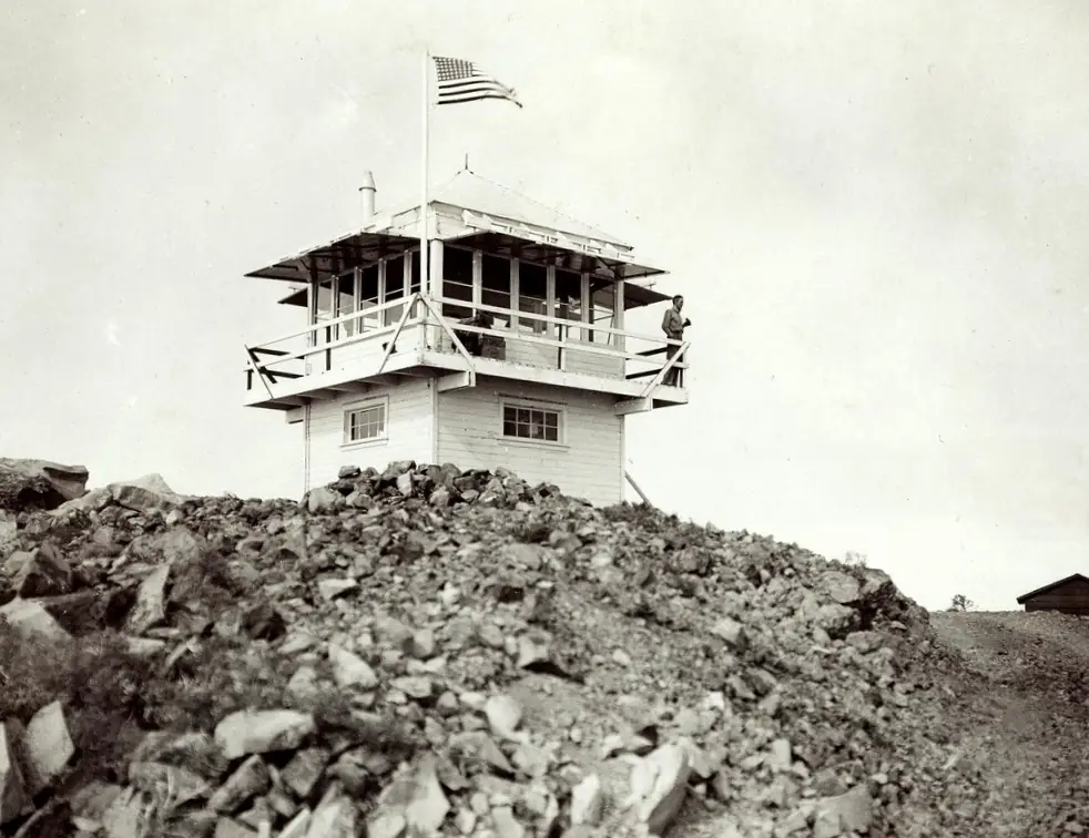
A lookout station was planned there in 1934.2 A 1934 newspaper item said the road to the top was nearly finished, built by a Civilian Conservation Corps crew, and that a lookout station would go up "probably this fall."2 The Register says a lookout structure stood on the mountain before 1936, on a 10-foot enclosed timber tower.1
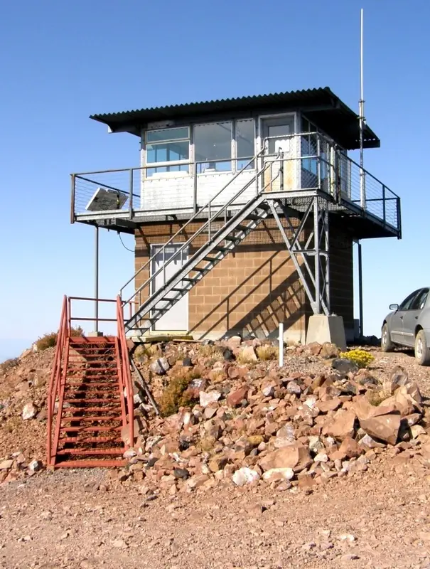
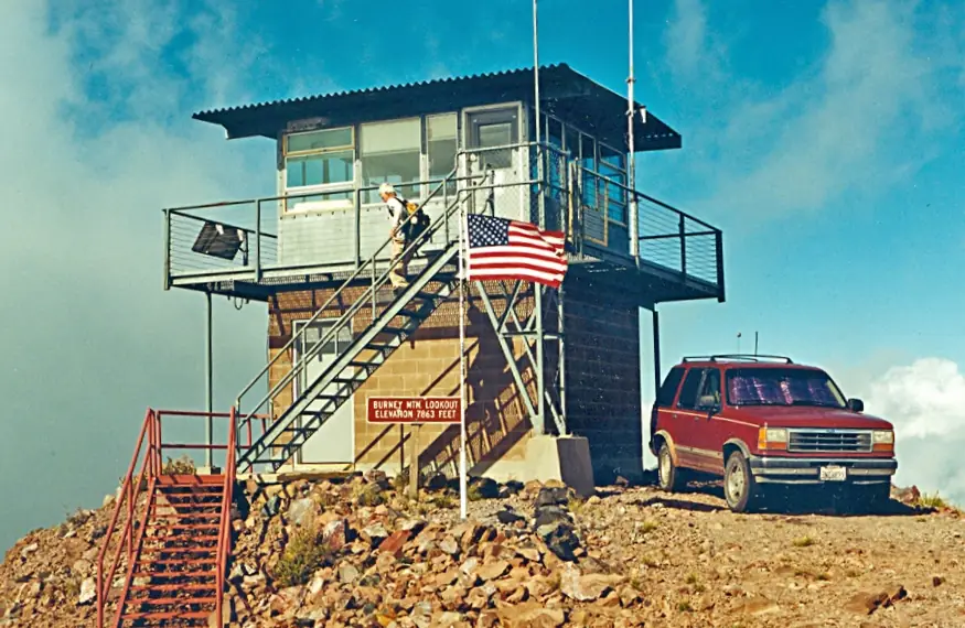
The building that stands there now is, by the Register's account, the replacement.1 In 1965 the Lassen forest supervisor announced that the old tower would be taken down and a new lookout of concrete block and a steel cab would take its place.2 The Register dates the new lookout to 1966 and describes it as a 13-by-13-foot cab on a 10-foot block tower.1 A 1973 survey note says the old tower had been removed and a new building set in a slightly different spot.2
Few staff names survive. Paul Davis was the lookout for the 1938 season before he left for college, and Dell Duey spent the summer of 1971 at the station.2 None of the sources read names a fire the lookout spotted.
The dates do not all agree. A Burney Chamber of Commerce page dates the tower to 1934, with a rebuild in 1960.3 That does not match the Register's 1966 date or the 1965 announcement, so the Chamber's version stays unconfirmed.
Today the Forest Fire Lookout Association's county list shows the lookout as standing, and the Register records its registration on October 26, 2019.4,1 The Chamber says the tower is still used.3 A peak-bagging guide tells visitors to park at an upper gate and walk the last stretch to the lookout, and it lists an active logging area among the drawbacks of the road.5 The sources do not say whether the cab is open to visitors. Check with the Lassen National Forest before going, and do not climb the tower unless it is open to the public.
- Burney Mountain Lookout, National Historic Lookout Register (nhlr.org), http://nhlr.org/lookouts/us/ca/burney-mountain-lookout/ (accessed 2026-10-08). ↩
- Burney Mountain - Forest Lookouts, California Lookouts (californialookouts.weebly.com), https://californialookouts.weebly.com/burney-mountain.html (accessed 2026-10-08). ↩
- Recreation, Burney Chamber of Commerce, https://www.burneychamber.com/recreation (accessed 2026-10-08). ↩
- California Lookouts by County, Forest Fire Lookout Association, https://firelookout.org/lookouts/us/ca/ca-co/ (accessed 2026-10-08). ↩
- Burney Mountain Peak Bagging, The Huntin Daddy, https://thehuntindaddy.com/index.php/peak-bagging/burney-mountain/ (accessed 2026-10-08). ↩
Photos
Photos keep their own rights and are shown with credit. Is one of these yours? You can ask for a different credit or for removal.
Sources
- National Historic Lookout Register (NHLR) (opens another site) Gave us: name, location, county, elevation, register numbers, agency, ownership, dates, photos, links National Historic Lookout Register (nhlr.org) · All rights reserved (American Resources, Inc.); facts extracted only, no prose copied. · retrieved 4 Oct 2026
- Forest Fire Lookout Association (FFLA) - US lookout lists (opens another site) Gave us: type, status, register numbers, links Forest Fire Lookout Association (firelookout.org) · No licence stated; facts extracted only, no prose copied. · retrieved 8 Oct 2026
- FOREST LOOKOUTS -- western US (Ron Kemnow's weebly sites) (opens another site) Gave us: links Ron Kemnow's Forest Lookouts sites (westlookouts, californialookouts, idaholookouts, montanalookouts, oregonlookouts and washingtonlookouts .weebly.com) · No licence stated; facts only (county, land manager, status word, coordinates where the page's own map widget gives them, township-range-section, height and design hints, links). The site's own newspaper quotes, citations and narrative are not reproduced. · retrieved 8 Oct 2026
- Firefinder research Gave us: summary, design, agency, access, visiting details, dates, links, fact-check Firefinder research (sources cited in the story footnotes) · Our own research notes; each fact cites its source in the lookout's story
More about this lookout elsewhere
- NHLR register entry US 1344 (nhlr.org) (opens another site)
- Recreation (Burney Chamber of Commerce) (opens another site)
- Burney Mountain Peak Bagging (The Huntin Daddy) (opens another site)
- California Lookouts by County (Forest Fire Lookout Association) (opens another site)
- FFLA California lookout list (firelookout.org) (opens another site)
- Burney Mountain on Forest Lookouts, western US (Ron Kemnow) (opens another site)
Firefinder takes facts (places, dates, numbers) from these sources and writes its own words. See all sources and licences.