Fire lookout · Tehama County, California
Eagle Peak Lookout
Tehama County tower with a 1963 steel cab on a lookout site used since at least 1933; CAL FIRE site, NHLR-registered 2019; last staffing listed 2008.
- Standing
- Restricted access
- Verified
Visit & stay
Not rentable. As far as we know, this lookout cannot be booked for overnight stays.
Access
Restricted access
Access is seasonal, gated or needs a permit. Check before you go. Site is 2.7 miles from the nearest paved road (NHLR); CAL FIRE does not rent lookouts (2008 CAL FIRE list)
- Can you climb it?
- Unknown
- Road to the top?
- Unknown
- Staffing
- Unknown
Facts
- Status
- Type
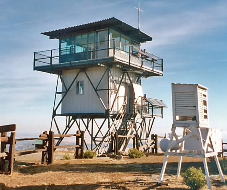
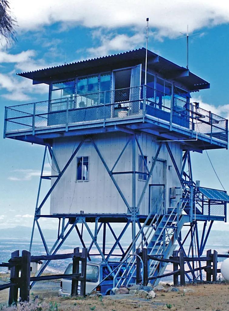
- Cab on a towerSteel cab based on USFS design CL-30 on a USFS 1600-series tower; earlier BC-301 cab on an enclosed timber towerThe designs: BC-301, CL-100, L-1600 steel tower
- Built of
- Not recorded
- Built
- 1963
- Height
- Unknown
- Elevation
- 3,715 ft (1,132 m)
- Agency
- California Department of Forestry and Fire Protection - Tehama-Glenn Unit (Cal Fire TGU)
- Land
- Federal land
- Location
- Tehama County, California
- Coordinates
- 39.92713, −122.64190
- Registers
- This entry
- VerifiedResearched, then checked independently. Updated 8 Oct 2026.
- Firefinder id
us-ca-eagle-peak-2
View from the cab
What you see from the cab: every ridge out to about 93 miles, the named peaks in sight, and other fire lookouts within view, worked out from terrain data in your browser.
Downloads about 3.6 MB of terrain data the first time.
Or see what it could see on the map: the ground in its line of sight.
History
Then and now
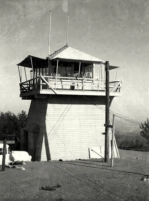
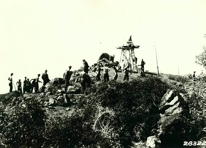
- 1933 EventEarliest known lookout structure here, an open platform, per NHLR: 'since at least 1933'Source: nhlr.org
- 1938 EventOctober 14, 1938 item: station known locally as Pigeon Roost, because wandering homing pigeons favored itSource: californialookouts.weebly.com
- No record between 1938 and 1963
- 1963 BuiltCurrent tower and steel cab; the year is written on the northwest pierSource: nhlr.org
- 1971 FireSmoke from a 100-acre grass fire west of Henleyville was spotted from the lookout (Red Bluff Daily News item of July 27, 1971, reprinted)Source: californialookouts.weebly.com
- 1972 EventCalifornia Department of Forestry took over the siteSource: nhlr.org
- 1982 AlteredLower room added 'ten years later' than the 1972 takeover; the year is derived from that phrase; the story says about a decade laterSource: nhlr.org
- No record between 1982 and 2008
- 2008 StaffedJune 2008 CAL FIRE list names lookouts that may be staffed in the 2008 fire season, including Eagle PeakSource: citlink.net
- 2019 Added to the National Historic Lookout RegisterRegistered October 28, 2019 as US 1360, CA 183Source: nhlr.org
- TodayStandingIt still stands, as far as our sources know.
Old maps of this spot
USGS topographic maps from the years a lookout stood may show it, often as a small symbol labelled “Lookout”. See the old topo maps around it on the Firefinder map, or find every scanned sheet of this spot on USGS TopoView (opens another site) (click the spot there to list them, with dates and downloads).
Story
Researched 8 Oct 2026, fact-checked.
Records place a lookout on Eagle Peak in Tehama County as early as 1933, when the first structure was an open platform.1 A BC-301 cab later sat atop an enclosed timber tower.1 The current tower has "1963" on its northwest pier, and its steel cab, made by California Blow Pipe of Escalon, California, follows a Forest Service design known as CL-30.1
The California Department of Forestry took the site over in 1972, and a lower room was added about a decade later.1 The Tehama-Glenn Unit of Cal Fire administers it today.1
A July 1971 item from the Red Bluff Daily News, reprinted on a Forest Lookouts page, describes a grass fire that burned 100 acres west of Henleyville on Paskenta Road.2 It notes that "Smoke was spotted from the Eagle Peak Lookout, located northwest of Paskenta."2 The same page recounts an October 1938 item saying the station was known locally as Pigeon Roost, because wandering homing pigeons favored it.2
A CAL FIRE list from June 2008 names Eagle Peak among the lookouts that may be staffed during that fire season.3 The same list says most lookouts are "staffed only during peak fire season, or during high fire danger times."3 The sources read give no later staffing record.
The Register rates access as restricted, since the nearest paved road is 2.7 miles away.1 The Forest Fire Lookout Association lists the tower as standing.4 The Register listed the lookout on October 28, 2019 as US 1360, CA 183.1 The 2008 CAL FIRE document says the agency does not rent lookouts.3 The sources read do not say whether the public can visit, so check with CAL FIRE before any trip.
- Eagle Peak Lookout, National Historic Lookout Register, http://nhlr.org/lookouts/us/ca/eagle-peak-lookout/ (accessed 2026-10-08). ↩
- Eagle Peak - Forest Lookouts, Forest Lookouts, https://californialookouts.weebly.com/eagle-peak.html (accessed 2026-10-08). ↩
- Lookouts, CAL FIRE (June 2008), copy hosted at citlink.net, https://www.citlink.net/~dburnett/CAL%20FIRE%20DATA/Lookouts.pdf (accessed 2026-10-08). ↩
- California Lookouts (by County), Forest Fire Lookout Association, https://firelookout.org/lookouts/us/ca/ (accessed 2026-10-08). ↩
Photos
Photos keep their own rights and are shown with credit. Is one of these yours? You can ask for a different credit or for removal.
Sources
- National Historic Lookout Register (NHLR) (opens another site) Gave us: name, location, county, elevation, register numbers, agency, dates, photos, links National Historic Lookout Register (nhlr.org) · All rights reserved (American Resources, Inc.); facts extracted only, no prose copied. · retrieved 4 Oct 2026
- Forest Fire Lookout Association (FFLA) - US lookout lists (opens another site) Gave us: type, status, register numbers, links Forest Fire Lookout Association (firelookout.org) · No licence stated; facts extracted only, no prose copied. · retrieved 8 Oct 2026
- FOREST LOOKOUTS -- western US (Ron Kemnow's weebly sites) (opens another site) Gave us: ownership Ron Kemnow's Forest Lookouts sites (westlookouts, californialookouts, idaholookouts, montanalookouts, oregonlookouts and washingtonlookouts .weebly.com) · No licence stated; facts only (county, land manager, status word, coordinates where the page's own map widget gives them, township-range-section, height and design hints, links). The site's own newspaper quotes, citations and narrative are not reproduced. · retrieved 8 Oct 2026
- Firefinder research Gave us: summary, design, status, agency, access, dates, links, fact-check Firefinder research (sources cited in the story footnotes) · Our own research notes; each fact cites its source in the lookout's story
More about this lookout elsewhere
- NHLR register entry US 1360 (nhlr.org) (opens another site)
- CAL FIRE Lookouts (June 2008) (CAL FIRE (copy hosted at citlink.net)) (opens another site)
- FFLA California lookout list (firelookout.org) (opens another site)
- Eagle Peak Lookout - Forest Lookouts Page (opens another site)
Firefinder takes facts (places, dates, numbers) from these sources and writes its own words. See all sources and licences.