Fire lookout · Tehama County, California
Inskip Hill Lookout
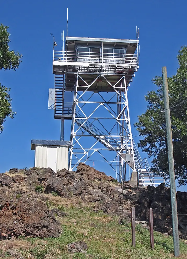
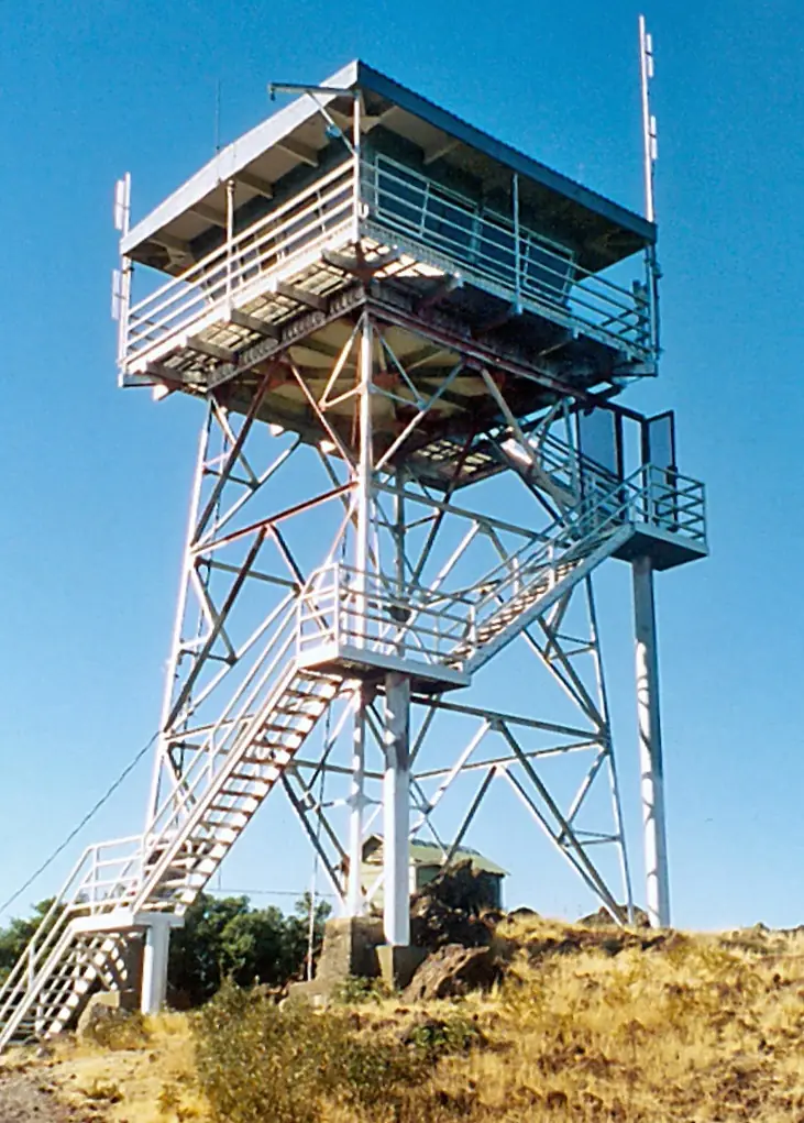
CCC-era 1934 lookout on Inskip Hill in Tehama County with a steel tower and a 1974 cab; the 2024 Park Fire damaged outbuildings and a rebuild was planned for 2025.
- Standing
- Restricted access
- Verified
Visit & stay
Not rentable. As far as we know, this lookout cannot be booked for overnight stays.
Access
Restricted access
Access is seasonal, gated or needs a permit. Check before you go. Sources conflict. The Register, citing a note dated October 1991, says the station is accessible to the public, 4.5 miles from the nearest paved road. Peakbagging says it is on private land. A CAL FIRE reconstruction is planned for 2025; its completion is unconfirmed. Check with CAL FIRE before going.
- Can you climb it?
- Unknown
- Road to the top?
- Unknown
- Trail
- The Register says the station is 4.5 miles from the nearest paved road. Peakbagging says it is on private land. Do not climb the tower.
- Staffing
- Staffed during fire season (as of undated)
Facts
- Status
- Type
- Cab on a towerUSFS L-801 tower; cab replaced in 1974 with a 732-6A style cabThe designs: CDF 732-6A, BC-301
- Built of
- Not recorded
- Built
- 1934
- Height
- 40 ft (12.2 m)
- Elevation
- 3,100 ft (945 m)
- Agency
- California Department of Forestry and Fire Protection (CAL FIRE), Tehama-Glenn Unit
- Land
- Unknown
- Location
- Tehama County, California
- Coordinates
- 40.34158, −121.94329
- Registers
- This entry
- VerifiedResearched, then checked independently. Updated 8 Oct 2026.
- Firefinder id
us-ca-inskip-hill
View from the cab
What you see from the cab: every ridge out to about 93 miles, the named peaks in sight, and other fire lookouts within view, worked out from terrain data in your browser.
Downloads about 3.2 MB of terrain data the first time.
Or see what it could see on the map: the ground in its line of sight.
History
Then and now
- 1934 BuiltOriginal CCC-era lookout built for the Forest Service; tower and garage built by CCC crews.Source: nhlr.org
- 1935 StaffedNewspaper item (Oroville Mercury, June 22, 1935, as transcribed): a 40-foot steel tower carrying the lookout, manned by Victor Mentink.Source: californialookouts.weebly.com
- 1937 StaffedHubert Grissom, lookout (Lassen Advocate item, June 21, 1937, as transcribed).Source: californialookouts.weebly.com
- No record between 1937 and 1958
- 1958 Last staffedLassen National Forest staffed or operated the site until 1958.Sources: nhlr.org, instagram.com
- 1971 EventTower and immediate property quit claimed to CDF.Source: nhlr.org
- 1972 AlteredStairway replaced.Source: nhlr.org
- 1973 FireA 13,000-acre fire near Red Bluff knocked out power lines to the tower, the main radio relay point for local law enforcement (Nevada State Journal item, August 21, 1973, as transcribed).Source: californialookouts.weebly.com
- 1974 AlteredBC-3 cab replaced with a 732-6A style cab. The original cab (BC-301) had been destroyed by fire; the date of the fire is not given.Source: nhlr.org
- No record between 1974 and 2019
- 2019 Added to the National Historic Lookout RegisterDate registered per the Register: October 28, 2019.Source: nhlr.org
- 2024 FirePark Fire damaged the garage, electrical infrastructure and privy. The lookout itself survived, per the Forest Fire Lookout Association's August 2024 post.Sources: ceqanet.lci.ca.gov, instagram.com, the-lookout.org
- 2024 EventCAL FIRE Notice of Exemption for the Inskip Lookout Reconstruction Project, received December 17, 2024. Phase III planned for spring-summer 2025; completion not confirmed in the sources read.Source: ceqanet.lci.ca.gov
- TodayStandingIt still stands, as far as our sources know.
Old maps of this spot
USGS topographic maps from the years a lookout stood may show it, often as a small symbol labelled “Lookout”. See the old topo maps around it on the Firefinder map, or find every scanned sheet of this spot on USGS TopoView (opens another site) (click the spot there to list them, with dates and downloads).
Story
Researched 8 Oct 2026, fact-checked.
Inskip Hill Lookout stands on the summit of Inskip Hill, a twin-peaked cinder cone west of Lassen Volcanic National Park, near Paynes Creek in Tehama County.1,2,3 The original lookout was a Civilian Conservation Corps-era station built for the Forest Service in 1934. Its tower follows a Forest Service L-801 design, and CCC crews built the tower and the garage.1
A 1935 newspaper item describes a 40-foot steel tower carrying the lookout, manned by Victor Mentink.4 In 1937 Hubert Grissom was the lookout.4 The Lassen National Forest staffed the site until 1958.1,3 The tower and its immediate property were quit claimed to the California Department of Forestry (CDF) in 1971, and the stairway was replaced in 1972.1
The original cab was destroyed by fire.1 In 1974 the cab then in place was replaced with one in the 732-6A style.1 Sources disagree on when the steel tower went up. The 1935 newspaper already describes one, while Peakbagging says the steel tower replaced the 1934 lookout around 1975.4,5
In August 1973 a 13,000-acre fire near Red Bluff knocked out power lines to the tower, which was then the main radio relay point for local law enforcement.4
In 2024 the Park Fire reached the hill.2,6 The Lookout's satellite view from July 27 shows active fire backing down Inskip Hill.6 The Forest Fire Lookout Association reported in August that the lookout survived its brush with the Park Fire.3 A CAL FIRE notice received in December 2024 covers the replacement of damaged structures.2 The garage, electrical infrastructure and privy were to be removed and rebuilt, with a new 2,500-gallon water tank.2 The tower is not listed among the damaged parts.2 The notice planned the work for 2025, and the sources read do not confirm that it was finished.2
Staffing is also disputed. The Forest Fire Lookout Association says the lookout is not normally staffed by CAL FIRE.3 Peakbagging says a Forest Service employee now staffs it during fire season.5 The Register, citing an October 1991 visit note, says the public can reach the station, which lies 4.5 miles from the nearest paved road.1 Peakbagging instead says it is on private land.5 Given that conflict and the planned rebuilding, check with CAL FIRE before going, and do not climb the tower.
- Inskip Hill Lookout, National Historic Lookout Register, http://nhlr.org/lookouts/us/ca/inskip-hill-lookout/ (accessed 2026-10-08). ↩
- Inskip Lookout Reconstruction Project, CEQAnet, CAL FIRE Notice of Exemption, https://ceqanet.lci.ca.gov/2024120733 (accessed 2026-10-08). ↩
- Forest Fire Lookout Association, Instagram post dated August 31, 2024, https://www.instagram.com/p/C_VIYALCacp/ (accessed 2026-10-08). ↩
- Inskip Hill, Forest Lookouts (California), https://californialookouts.weebly.com/inskip-hill.html (accessed 2026-10-08). ↩
- Inskip Hill Lookout, California, Peakbagging, http://www.peakbagging.com/CALookoutPhotos/InskipHill.html (accessed 2026-10-08). ↩
- Park Fire from Space - 7/27/2024, The Lookout, https://the-lookout.org/2024/07/27/park-fire-from-space-7-27-2024/ (accessed 2026-10-08). ↩
Photos
Photos keep their own rights and are shown with credit. Is one of these yours? You can ask for a different credit or for removal.
Sources
- National Historic Lookout Register (NHLR) (opens another site) Gave us: name, location, county, elevation, register numbers, agency, dates, photos, links National Historic Lookout Register (nhlr.org) · All rights reserved (American Resources, Inc.); facts extracted only, no prose copied. · retrieved 4 Oct 2026
- Forest Fire Lookout Association (FFLA) - US lookout lists (opens another site) Gave us: type, status, register numbers, links Forest Fire Lookout Association (firelookout.org) · No licence stated; facts extracted only, no prose copied. · retrieved 8 Oct 2026
- OpenStreetMap -- fire lookout structures (opens another site) Gave us: links © OpenStreetMap contributors · ODbL 1.0. (c) OpenStreetMap contributors. · retrieved 4 Oct 2026
- FOREST LOOKOUTS -- western US (Ron Kemnow's weebly sites) (opens another site) Gave us: height, links Ron Kemnow's Forest Lookouts sites (westlookouts, californialookouts, idaholookouts, montanalookouts, oregonlookouts and washingtonlookouts .weebly.com) · No licence stated; facts only (county, land manager, status word, coordinates where the page's own map widget gives them, township-range-section, height and design hints, links). The site's own newspaper quotes, citations and narrative are not reproduced. · retrieved 8 Oct 2026
- Firefinder research Gave us: summary, design, height, status, agency, access, staffing, visiting details, dates, links, fact-check Firefinder research (sources cited in the story footnotes) · Our own research notes; each fact cites its source in the lookout's story
More about this lookout elsewhere
- NHLR register entry US 1361 (nhlr.org) (opens another site)
- Inskip Hill Lookout, California (Peakbagging) (opens another site)
- Inskip Lookout Reconstruction Project (CEQAnet (CAL FIRE Notice of Exemption)) (opens another site)
- Forest Fire Lookout Association Instagram post, August 31, 2024 (Forest Fire Lookout Association (Instagram)) (opens another site)
- Park Fire from Space - 7/27/2024 (The Lookout) (opens another site)
- FFLA California lookout list (firelookout.org) (opens another site)
- Inskip Hill on Forest Lookouts, western US (Ron Kemnow) (opens another site)
- OpenStreetMap way 1049165317 (opens another site)
Firefinder takes facts (places, dates, numbers) from these sources and writes its own words. See all sources and licences.