Fire lookout · Santa Barbara County, California
Madulce Peak Lookout Site
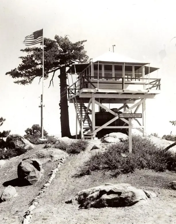
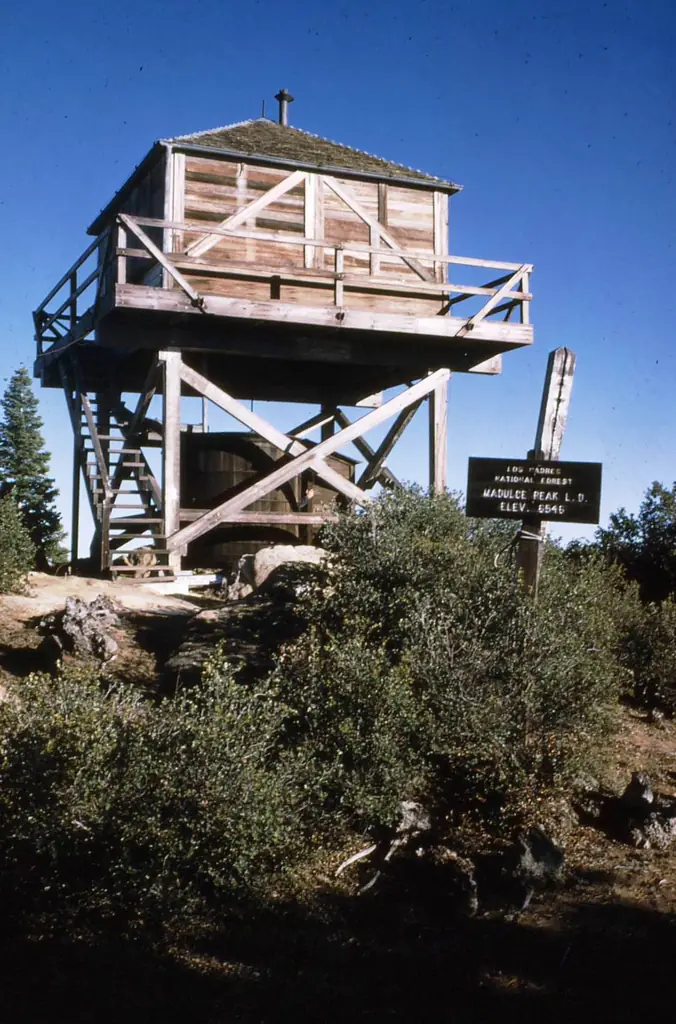
Los Padres lookout on Madulce Peak, built 1934 for the Santa Barbara National Forest; a 1972 windstorm destroyed the cab and a 2018 trip report describes foundations on the summit.
- Gone
- Open to the public
- Verified
Gone: The lookout no longer stands. Only the site is left. Cab destroyed in a 1972 windstorm and the rest later removed; a 2018 trip report describes foundations on the summit
Visit & stay
Gone: site only. The lookout no longer stands, so there is nothing to climb or rent. You may still be able to visit the site.
Access
Open to the public. Inside the Dick Smith Wilderness (64,700 acres); no vehicle access to the summit is described in the sources read
- Road to the top?
- Unknown
- Trail
- Trip reports describe a faint trail, with the turns near the summit mostly marked by cairns and flagging tape
Facts
- Status
- Type
- Cab on a towerCalifornia Region 5 Plan BC-301, 10-foot open timber towerThe design: BC-301
- Built of
- Wood
- Built
- 1934
- Height
- Unknown
- Elevation
- 6,543 ft (1,994 m)
- Agency
- US Forest Service - Los Padres National Forest
- Land
- Federal land
- Location
- Santa Barbara County, California
- Coordinates
- 34.69104, −119.59122
- Registers
- This entry
- VerifiedResearched, then checked independently. Updated 9 Oct 2026.
- Firefinder id
us-ca-madulce-peak
View from the cab
What the lookout saw from its cab: every ridge out to about 93 miles, the named peaks in sight, and other fire lookouts within view, worked out from terrain data in your browser.
This lookout is gone. The view is reconstructed from its recorded site and a typical height for a lookout like it.
Downloads about 3.2 MB of terrain data the first time.
Or see what it could see on the map: the ground in its line of sight.
History
Then and now
- 1932 FireWeek-old fire moved north toward the peak and keeper Edward Decker left the post; the register says an earlier lookout burned, but the next day's paper said the burning reports were wrongSources: firetower.org, californialookouts.weebly.com
- 1934 BuiltBuilt for the Santa Barbara National Forest as a 10-foot open timber tower to Plan BC-301Sources: firetower.org, californialookouts.weebly.com
- 1934 EventTrail to the lookout completed by late August 1934Source: californialookouts.weebly.com
- No record between 1934 and 1972
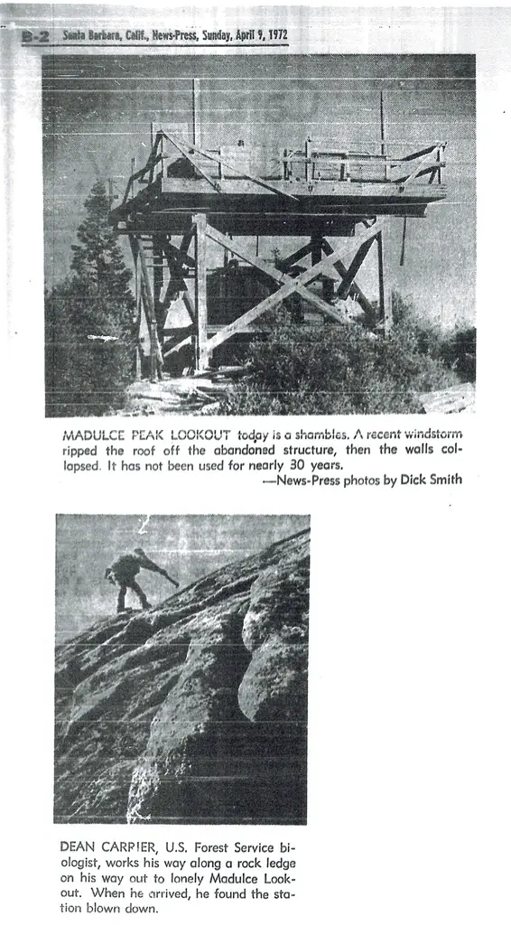
- 1972 DestroyedWindstorm took off the roof, then the walls collapsed; the rest was removed afterwardSource: firetower.org
- 1972 Removed'Removed' field on FFLOS detail page: "1972".Source: FFLOS register entry
- No record between 1972 and 2019
- 2019 Added to the Former Fire Lookout Sites RegisterRegistered December 19, 2019; nominated by Brad EellsSource: firetower.org
- TodayGoneThe lookout no longer stands. Only the site is left.
Old maps of this spot
USGS topographic maps from the years a lookout stood may show it, often as a small symbol labelled “Lookout”. See the old topo maps around it on the Firefinder map, or find every scanned sheet of this spot on USGS TopoView (opens another site) (click the spot there to list them, with dates and downloads).
Story
Researched 9 Oct 2026, fact-checked.
Madulce Peak rises in the Santa Barbara backcountry, where a Forest Service page on the Dick Smith Wilderness says it tops a knot of mountains.1 The lookout on the peak dates to 1934, when the Santa Barbara National Forest had it built to California Region 5 Plan BC-301: a timber tower 10 feet tall with an open design.2,3 By the end of that August a trail had been completed to it, the Santa Maria Daily Times reported.3
The register says the 1934 lookout replaced an earlier structure that fire destroyed in September 1932.2 That month a week-old fire swept north toward the peak, and the Oxnard Daily Courier first reported that the lookout had been destroyed.3 Its keeper, Edward Decker, had left the post as the blaze drew near.3 The same paper said the next day that the reports of the lookout burning were mistaken.3 The register's account and that newspaper correction do not agree.2,3
In 1972 a windstorm took the roof off the lookout, and its walls then collapsed.2 The register says the rest of the structure was removed afterward.2 A PeakVisor summit page instead says the old lookout was burned down in the 1970s, so the cause of its loss is disputed.4
Today the register places the site within the Los Padres National Forest.2 The Dick Smith Wilderness was set up in 1984 under the California Wilderness Act and covers 64,700 acres.1 A 2018 trip report describes foundations of an old lookout on the summit.5 The same writer described the trail as faint in most places, with the switchbacks near the top marked mainly by cairns and flagging tape.5 No other source read describes the summit now, and no recent survey or photo was found.
- Dick Smith Wilderness, Los Padres National Forest, US Forest Service, https://www.fs.usda.gov/r05/lospadres/recreation/dick-smith-wilderness (accessed 2026-10-09). ↩
- Madulce Peak Lookout Site, Former Fire Lookout Sites Register (firetower.org), http://firetower.org/lookouts/us/ca/madulce-peak-lookout-site/ (accessed 2026-10-09). ↩
- Madulce Peak - FOREST LOOKOUTS, Forest Lookouts (californialookouts.weebly.com), https://californialookouts.weebly.com/madulce-peak.html (accessed 2026-10-09). ↩
- Madulce Peak (1,993 m), PeakVisor, https://peakvisor.com/peak/madulce-peak.html (accessed 2026-10-09). ↩
- Madulce Peak trip reports, Peakery, https://peakery.com/madulce-peak-california/ (accessed 2026-10-09). ↩
Photos
Photos keep their own rights and are shown with credit. Is one of these yours? You can ask for a different credit or for removal.
Sources
- Former Fire Lookout Sites Register (FFLOS) (opens another site) Gave us: name, location, county, elevation, what it is built of, register numbers, agency, ownership, dates, photos, links Former Fire Lookout Sites Register (firetower.org) · All rights reserved (American Resources, Inc.); facts extracted only, no prose copied. · retrieved 4 Oct 2026
- Forest Fire Lookout Association (FFLA) - US lookout lists (opens another site) Gave us: type, status, register numbers, links Forest Fire Lookout Association (firelookout.org) · No licence stated; facts extracted only, no prose copied. · retrieved 8 Oct 2026
- FOREST LOOKOUTS -- western US (Ron Kemnow's weebly sites) (opens another site) Ron Kemnow's Forest Lookouts sites (westlookouts, californialookouts, idaholookouts, montanalookouts, oregonlookouts and washingtonlookouts .weebly.com) · No licence stated; facts only (county, land manager, status word, coordinates where the page's own map widget gives them, township-range-section, height and design hints, links). The site's own newspaper quotes, citations and narrative are not reproduced. · retrieved 8 Oct 2026
- Firefinder research Gave us: summary, design, status, agency, access, visiting details, dates, links, fact-check Firefinder research (sources cited in the story footnotes) · Our own research notes; each fact cites its source in the lookout's story
More about this lookout elsewhere
- FFLOS register entry US 1856 (firetower.org) (opens another site)
- Madulce Peak (1,993 m) (PeakVisor) (opens another site)
- Dick Smith Wilderness (Los Padres National Forest, US Forest Service) (opens another site)
- Madulce Peak trip reports (Peakery) (opens another site)
- FFLA California lookout list (firelookout.org) (opens another site)
- Madulce Peak Lookout - Ron Kemnow Page (opens another site)
Firefinder takes facts (places, dates, numbers) from these sources and writes its own words. See all sources and licences.