Fire lookout · Santa Barbara County, California
McPherson Mountain Lookout Site
Also known as McPherson Peak
Ground cabin on McPherson Peak, built 1934 and staffed 1935-39; removal date disputed, and the summit held Air Force communication arrays in 2011.
- Gone
- Access unknown
- Verified
Gone: The lookout no longer stands. Only the site is left. Structure removed or burned after 1984 (sources disagree on which); mounting piers and a concrete cistern remain per the register; a 2011 visit found Air Force communication arrays on the summit.
Visit & stay
Gone: site only. The lookout no longer stands, so there is nothing to climb or rent.
Access
Access unknown
We do not know the access rules. Check with the land manager before you go.
- Road to the top?
- Unknown
- Trail
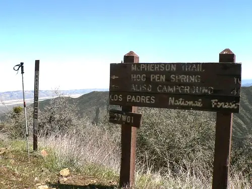
- A 3.35-mile McPherson Trail is listed by a trail guide; no source says whether the summit is open to visitors.
Facts
- Status
- Type
- Ground-level cabCalifornia Region 5 Plan BC-301 ground cabin, not on a towerThe design: BC-301
- Built of
- WoodGoing by its design; no source says so in words.
- Built
- 1934
- Height
- Unknown
- Elevation
- 5,755 ft (1,754 m)
- Agency
- US Forest Service - Los Padres National Forest
- Land
- Federal land
- Location
- Santa Barbara County, California
- Coordinates
- 34.88853, −119.81282
- Registers
- This entry
- VerifiedResearched, then checked independently. Updated 9 Oct 2026.
- Firefinder id
us-ca-mcpherson-mountain
View from the cab
What the lookout saw from its cab: every ridge out to about 93 miles, the named peaks in sight, and other fire lookouts within view, worked out from terrain data in your browser.
This lookout is gone. The view is reconstructed from its recorded site and a typical height for a lookout like it.
Downloads about 3.1 MB of terrain data the first time.
Or see what it could see on the map: the ground in its line of sight.
History
Then and now
- 1934 BuiltGround cabin, California Region 5 Plan BC-301; no towerSource: firetower.org
- 1935 FireJuly 1935 fire fanned by a 35-mile wind came within 400 yards of the stationSource: californialookouts.weebly.com
- 1935 First staffedTwo CCC men named to fire lookouts; Bill Hoey put in charge at McPherson with a radioSource: californialookouts.weebly.com
- 1937 StaffedConrad Munson assigned to the lookoutSource: californialookouts.weebly.com
- 1939 Last staffedMunson relieved in December 1939 as the last of the district's protection force for the seasonSource: californialookouts.weebly.com
- No record between 1939 and 1967
- 1967 EventBids announced for an eight-mile fire protection road to the lookoutSource: californialookouts.weebly.com
- No record between 1967 and 1984
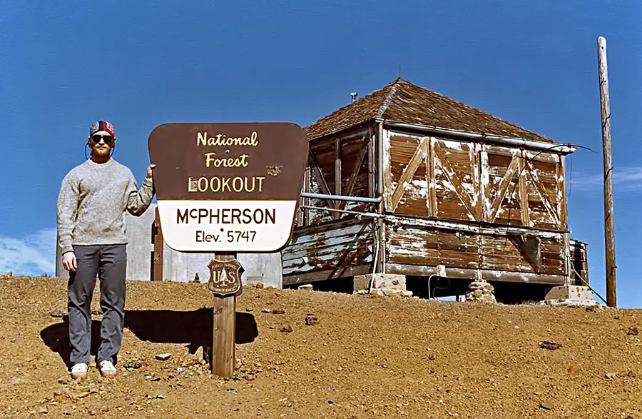
- 1984 AbandonedPhoto caption: in poor condition and not in service, November 1984Source: peakbagging.com
- 1987 BurnedSingle source (trail guide) says the facility burned April 7, 1987; FFLOS and Carey say removedSource: hikelospadres.com
- No record between 1987 and 2019
- 2019 Added to the Former Fire Lookout Sites RegisterRegistered on the Former Fire Lookout Sites register December 20, 2019Source: firetower.org
- TodayGoneThe lookout no longer stands. Only the site is left.
Old maps of this spot
USGS topographic maps from the years a lookout stood may show it, often as a small symbol labelled “Lookout”. See the old topo maps around it on the Firefinder map, or find every scanned sheet of this spot on USGS TopoView (opens another site) (click the spot there to list them, with dates and downloads).
Story
Researched 9 Oct 2026, fact-checked.
The McPherson Mountain lookout went up in 1934 as a ground-level cabin on a peak in the Los Padres National Forest, Santa Barbara County.1 Craig Carey's 2011 account says the lookout sat on the ground rather than on a tower, a choice he ties to the peak's views and prominence.2
In June 1935 the district ranger named two CCC men to fire lookouts and put Bill Hoey of Santa Maria in charge at McPherson.3 Hoey ran the lookout's radio, reporting to Santa Barbara every hour that summer.3 In July a fire being fanned by a 35-mile wind came within 400 yards of the station.3 Conrad Munson was assigned there in 1937. In December 1939 he was relieved as the last of the district's protection force at the close of the season.3
Sources disagree on what became of the structure. The Former Fire Lookout Sites register says the structure was taken down at some point after 1984; only the mounting piers and a concrete cistern remain.1 A photo from November 1984 shows the lookout in poor condition and out of service.4 Carey dates its removal to the late 1980s.2 A trail guide says the facility was built in 1934 and burned on April 7, 1987.5
When Carey visited in 2011, the summit was taken up by US Air Force communication arrays and related buildings.2 According to the trail guide, the only surviving piece of the old lookout is a large concrete tank for collecting rainwater.5 A 1967 notice had said bids were being taken for an eight-mile fire protection road to the lookout.3 None of these sources says whether the summit is open to visitors now.
- McPherson Mountain Lookout Site, Former Fire Lookout Sites, http://firetower.org/lookouts/us/ca/mcpherson-mountain-lookout-site/ (accessed 2026-10-09). ↩
- Craig R. Carey, "Lookout! No. 4: McPherson Peak", http://www.craigrcarey.net/2011/07/lookout-mcpherson-peak/ (accessed 2026-10-09). ↩
- McPherson Mountain - Forest Lookouts (newspaper excerpts), California Lookouts, https://californialookouts.weebly.com/mcpherson-mountain.html (accessed 2026-10-09). ↩
- Mc Pherson Peak (LO site), California, Peakbagging, http://peakbagging.com/CALookoutPhotos/McPhersonPeak.html (accessed 2026-10-09). ↩
- Mcpherson Trail - Los Padres National Forest, HikeLosPadres, https://www.hikelospadres.com/mcpherson-trail.html (accessed 2026-10-09). ↩
Photos
Photos keep their own rights and are shown with credit. Is one of these yours? You can ask for a different credit or for removal.
Sources
- Former Fire Lookout Sites Register (FFLOS) (opens another site) Gave us: name, location, county, elevation, what it is built of, register numbers, agency, ownership, dates, photos, links Former Fire Lookout Sites Register (firetower.org) · All rights reserved (American Resources, Inc.); facts extracted only, no prose copied. · retrieved 4 Oct 2026
- Forest Fire Lookout Association (FFLA) - US lookout lists (opens another site) Gave us: type, status, register numbers, links Forest Fire Lookout Association (firelookout.org) · No licence stated; facts extracted only, no prose copied. · retrieved 8 Oct 2026
- FOREST LOOKOUTS -- western US (Ron Kemnow's weebly sites) (opens another site) Ron Kemnow's Forest Lookouts sites (westlookouts, californialookouts, idaholookouts, montanalookouts, oregonlookouts and washingtonlookouts .weebly.com) · No licence stated; facts only (county, land manager, status word, coordinates where the page's own map widget gives them, township-range-section, height and design hints, links). The site's own newspaper quotes, citations and narrative are not reproduced. · retrieved 8 Oct 2026
- Firefinder research Gave us: summary, design, status, agency, visiting details, dates, links, fact-check Firefinder research (sources cited in the story footnotes) · Our own research notes; each fact cites its source in the lookout's story
More about this lookout elsewhere
- FFLOS register entry US 1860 (firetower.org) (opens another site)
- Mc Pherson Peak (LO site), California (Peakbagging) (opens another site)
- Mcpherson Trail - Los Padres National Forest (HikeLosPadres) (opens another site)
- FFLA California lookout list (firelookout.org) (opens another site)
- McPherson Mountain Lookout - Ron Kemnow Page (opens another site)
- Lookout! No. 4: McPherson Peak (opens another site)
Firefinder takes facts (places, dates, numbers) from these sources and writes its own words. See all sources and licences.