Fire lookout · Sonoma County, California
Mount Saint Helena Lookout Site
Sonoma/Lake/Napa tri-county lookout on Mount St. Helena, dedicated 1935, replaced 1950 (809R plan); staffing ended 1992 and it was later removed. Summit now has communications towers.
- Gone
- Restricted access
- Verified
Gone: The lookout no longer stands. Only the site is left. Removed some time after staffing ended in 1992; the register gives no removal date and no source describes what remains
Visit & stay
Gone: site only. The lookout no longer stands, so there is nothing to climb or rent.
Access
Restricted access
Access is seasonal, gated or needs a permit. Check before you go. On foot only, per a 1991 register note; hikers reach the summit from Robert Louis Stevenson State Park along a fire road
- Road to the top?
- Unknown
- Trail
- No lookout to climb. The Mount St. Helena Trail from Robert Louis Stevenson State Park is 5.3 miles with a 2,100-foot climb, to a summit with several communications towers
Facts
- Status
- Type
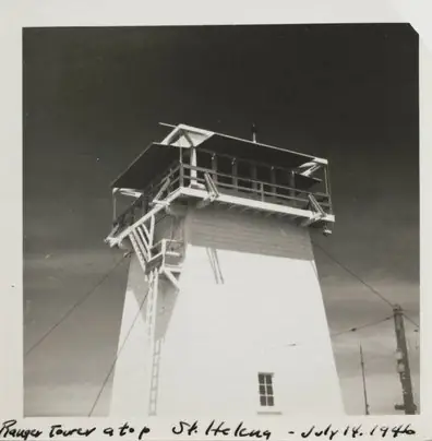
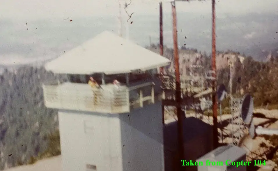
- Enclosed tower1935 lookout on a 30-foot enclosed tower, similar to a USFS BC-301 cabin plan; 1950 replacement tower conformed closely to the 809R planThe design: CDF 809R
- Built of
- Not recorded
- Built
- 1935
- Height
- Unknown
- Elevation
- 4,340 ft (1,323 m)
- Agency
- California Department of Forestry and Fire Protection
- Land
- Unknown
- Location
- Sonoma County, California
- Coordinates
- 38.66924, −122.63331
- Registers
- This entry
- VerifiedResearched, then checked independently. Updated 9 Oct 2026.
- Firefinder id
us-ca-mount-saint-helena
View from the cab
What the lookout saw from its cab: every ridge out to about 93 miles, the named peaks in sight, and other fire lookouts within view, worked out from terrain data in your browser.
This lookout is gone. The view is reconstructed from its recorded site and a typical height for a lookout like it.
Downloads about 3.6 MB of terrain data the first time.
Or see what it could see on the map: the ground in its line of sight.
History
Then and now
- 1935 BuiltConstructed and dedicated in 1935 on a 30-foot enclosed tower (register; newspapers of 1934-35 describe the tri-county station)Sources: californialookouts.weebly.com, firetower.org
- 1935 First staffedHjalmer Lundell, a former radio operator, named fire lookout in July 1935; a September 1935 report names Henry LundellSource: californialookouts.weebly.com
- 1942 EventBecame a repeater station for the Sonoma County police radio systemSource: californialookouts.weebly.com
- 1946 EventAn 85-mile-an-hour wind blew an aerial down and damaged the weather stationSource: californialookouts.weebly.com
- 1950 Built'Built' field on FFLOS detail pageSource: FFLOS register entry
- 1950 Replaced by a new structure1935 lookout replaced by a tower that conformed closely to the 809R planSource: firetower.org
- No record between 1950 and 1992
- 1992 EventAfter a statewide review of lookouts, a decision was made to cut funding for Mt. St. HelenaSource: californialookouts.weebly.com
- 1992 Removed'Removed' field on FFLOS detail page: "After 1992".Source: FFLOS register entry
- 1992 Last staffedRegister: the lookout ceased to be staffed in 1992Source: firetower.org
- No record between 1992 and 2019
- 2019 Added to the Former Fire Lookout Sites RegisterDate registered December 21, 2019Source: firetower.org
- TodayGoneThe lookout no longer stands. Only the site is left.
Old maps of this spot
USGS topographic maps from the years a lookout stood may show it, often as a small symbol labelled “Lookout”. See the old topo maps around it on the Firefinder map, or find every scanned sheet of this spot on USGS TopoView (opens another site) (click the spot there to list them, with dates and downloads).
Story
Researched 9 Oct 2026, fact-checked.
The lookout on Mount Saint Helena was a tri-county project. In May 1934 a Sonoma County paper reported that Sonoma, Lake and Napa counties would share the building and upkeep of a station on the summit.1 A newspaper predicted a panorama over much of the land from the Sierra to the Pacific, reaching from San Francisco Bay to the Siskiyous.1
The Former Fire Lookout Sites register says the lookout was constructed and dedicated in 1935, on a 30-foot enclosed tower of a design similar to a Forest Service cabin plan.2 Newspapers reported a dedication crowd of 250 to 300 people in July 1935.1 That July, Hjalmer Lundell, a former radio operator from St. Helena, was named fire lookout.1 A September 1935 report names a Henry Lundell as the state lookout on the summit. The sources do not say whether these are the same man.1
The register says the 1935 lookout was replaced in 1950 by a tower that conformed closely to the 809R plan.2 The station also took on other work. In 1942 it was pressed into service on the Sonoma County police radio network as a repeater on the summit.1 In 1946 a wind of 85 miles an hour knocked down an aerial and damaged the weather station.1
A 1992 decision followed a statewide review of lookouts and withdrew funding from the Mount St. Helena station.1 The register says staffing ended that year and the lookout was taken down some time afterward. It gives no date for the removal.2
A hiking guide says the summit now has several communications towers.3 Visitors can reach it on foot from Robert Louis Stevenson State Park.4 The Mount St. Helena Trail from the park is a fire road of 5.3 miles that climbs 2,100 feet, according to one guide, while Wikipedia gives the trails as about 6 miles long.3,4 A 1991 note in the register says the summit may be reached only on foot.2 We found no source that says whether any part of the lookout remains on the summit, or what the site looks like today.
- Mt. St. Helena, Forest Lookouts (California), https://californialookouts.weebly.com/mount-st-helena.html (accessed 2026-10-09). ↩
- Mount Saint Helena Lookout Site, Former Fire Lookout Sites, http://firetower.org/lookouts/us/ca/mount-saint-helena-lookout-site/ (accessed 2026-10-09). ↩
- Robert Louis Stevenson State Park - Mount St. Helena, Napa Hiking, https://www.napahiking.com/Robert_Louis_Stevenson.htm (accessed 2026-10-09). ↩
- Mount Saint Helena, Wikipedia, https://en.wikipedia.org/wiki/Mount_Saint_Helena (accessed 2026-10-09). ↩
Photos
Photos keep their own rights and are shown with credit. Is one of these yours? You can ask for a different credit or for removal.
Sources
- Former Fire Lookout Sites Register (FFLOS) (opens another site) Gave us: name, location, county, elevation, register numbers, agency, dates, photos, links Former Fire Lookout Sites Register (firetower.org) · All rights reserved (American Resources, Inc.); facts extracted only, no prose copied. · retrieved 4 Oct 2026
- Forest Fire Lookout Association (FFLA) - US lookout lists (opens another site) Gave us: type, status, register numbers, links Forest Fire Lookout Association (firelookout.org) · No licence stated; facts extracted only, no prose copied. · retrieved 8 Oct 2026
- FOREST LOOKOUTS -- western US (Ron Kemnow's weebly sites) (opens another site) Ron Kemnow's Forest Lookouts sites (westlookouts, californialookouts, idaholookouts, montanalookouts, oregonlookouts and washingtonlookouts .weebly.com) · No licence stated; facts only (county, land manager, status word, coordinates where the page's own map widget gives them, township-range-section, height and design hints, links). The site's own newspaper quotes, citations and narrative are not reproduced. · retrieved 8 Oct 2026
- Firefinder research Gave us: summary, design, status, agency, access, visiting details, dates, links, fact-check Firefinder research (sources cited in the story footnotes) · Our own research notes; each fact cites its source in the lookout's story
More about this lookout elsewhere
- FFLOS register entry US 1866 (firetower.org) (opens another site)
- Mount Saint Helena (Wikipedia) (opens another site)
- Robert Louis Stevenson State Park - Mount St. Helena (Napa Hiking (napahiking.com)) (opens another site)
- FFLA California lookout list (firelookout.org) (opens another site)
- Mount Saint Helena Lookout - Forest Lookouts Page (opens another site)
Firefinder takes facts (places, dates, numbers) from these sources and writes its own words. See all sources and licences.