Fire lookout · El Dorado County, California
Pilot Hill Lookout
El Dorado County enclosed tower: 1958 as-built plans, replacing a 1935 CCC lookout; volunteer-staffed since its 2019 reopening. Sources disagree on the build year.
- Standing
- Restricted access
- Verified
Visit & stay
Not rentable. As far as we know, this lookout cannot be booked for overnight stays.
Access
Restricted access
Access is seasonal, gated or needs a permit. Check before you go. Register: not readily accessible to the public; about 1.5 miles from a paved road, behind a private subdivision and security gate (note marked MVT 10/91)
- Can you climb it?
- Unknown
- Road to the top?
- Unknown
- Staffing
- Unknown
Facts
- Status
- Type
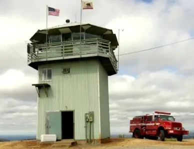
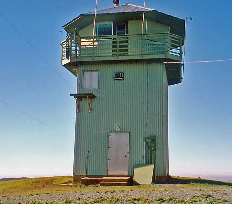
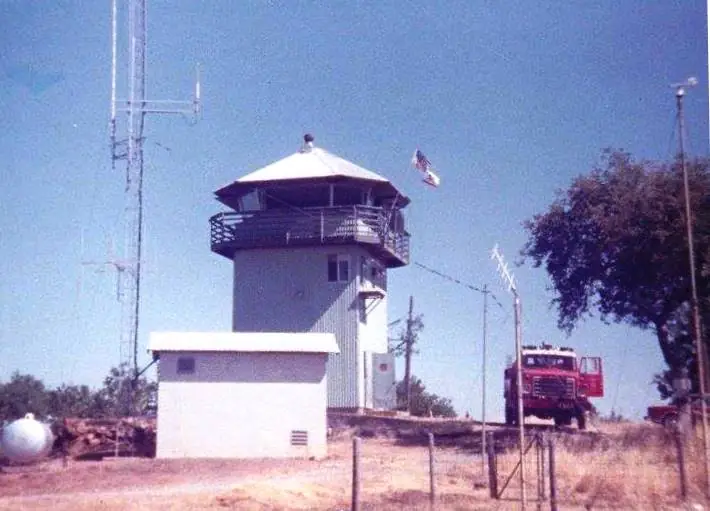
- Enclosed towerEnclosed tower based on the revised 809R plan, with a few deviations; aluminum sheeting, angled cab windows and steel mullionsThe design: CDF 809R
- Built of
- Not recorded
- Built
- 1935
- Height
- Unknown
- Elevation
- 1,869 ft (570 m)
- Agency
- California Department of Forestry and Fire Protection
- Land
- Unknown
- Location
- El Dorado County, California
- Coordinates
- 38.81816, −121.02987 sources disagree
- Registers
- This entry
- VerifiedResearched, then checked independently. Updated 8 Oct 2026.
- Firefinder id
us-ca-pilot-hill
View from the cab
What you see from the cab: every ridge out to about 93 miles, the named peaks in sight, and other fire lookouts within view, worked out from terrain data in your browser.
Downloads about 3.6 MB of terrain data the first time.
Or see what it could see on the map: the ground in its line of sight.
History
Then and now
- 1935 BuiltCCC lookout on the site, later replaced by the present buildingSource: nhlr.org
- No record between 1935 and 1958
- 1958 BuiltAs-built plans (Plan No. 237) drawn up in 1958; building believed to date from the Folsom Dam projectSource: nhlr.org
- No record between 1958 and 2008
- 2008 RemovedFire-watch cameras removed by 2008Source: peakbagging.com
- 2015 Added to the National Historic Lookout RegisterRegistered March 16, 2015 as US 1065, CA 106; nominated by Al RamirezSource: nhlr.org
- 2019 RestoredCAL FIRE repairs and renovations completed; tower reopened June 2019Source: peakbagging.com
- 2019 StaffedReopened staffed entirely by volunteers, mostly on 6 to 12 hour shiftsSources: peakbagging.com, cbsnews.com
- TodayStandingIt still stands, as far as our sources know.
Old maps of this spot
USGS topographic maps from the years a lookout stood may show it, often as a small symbol labelled “Lookout”. See the old topo maps around it on the Firefinder map, or find every scanned sheet of this spot on USGS TopoView (opens another site) (click the spot there to list them, with dates and downloads).
Story
Researched 8 Oct 2026, fact-checked.
The Register dates a bonfire on the highest peak in Pilot Hill to the Gold Rush era. It served as a signal fire for travelers and merchants carrying goods to the miners.1 The present building's date is disputed. The Register dates its as-built plans to 1958, says the building is thought to date from the Folsom Dam project, and says it succeeded a 1935 CCC lookout.1 Peakbagging.com instead gives 1985 for the tower, also tied to the Folsom Dam project.2 The Register's plan dates are the more specific, so this account leans toward 1958, but the sources disagree. The building is based on the revised 809R plan, with a few deviations. It has aluminum sheeting and angled cab windows.1
CAL FIRE lists the El Dorado County lookout as Pilot Peak Lookout in its Amador-El Dorado Unit.3 Peakbagging.com says the tower fell into disrepair, lost its roof in a storm, and had its cameras removed by 2008.2 After CAL FIRE finished repairs, volunteers took over the watch when the tower reopened in June 2019, mostly working 6 to 12 hour shifts.2 A CBS Sacramento report says the Pilot Peak Smoke Seekers, a volunteer group, keep watch for 12 hours a day, every day of the week through fire season, and that its volunteers were first to notice a fire.4 The sources do not say outright that the Pilot Peak name refers to this building, but the descriptions match, so this account treats them as one tower.
The Register says visitors cannot easily reach the site. It sits roughly 1.5 miles from a paved road, behind a private subdivision and a security gate, according to a note marked 10/91.1 The Forest Fire Lookout Association lists the tower as standing.5 Anyone planning a visit should ask CAL FIRE first.
- Pilot Hill Lookout, National Historic Lookout Register (nhlr.org), http://nhlr.org/lookouts/us/ca/pilot-hill-lookout/ (accessed 2026-10-08). ↩
- Pilot Hill Lookout, California, Peakbagging (peakbagging.com), http://www.peakbagging.com/CALookoutPhotos/PilotHill.html (accessed 2026-10-08). ↩
- Cal Fire Lookouts, CAL FIRE fact sheet (PDF), https://34c031f8-c9fd-4018-8c5a-4159cdff6b0d-cdn-endpoint.azureedge.net/-/media/calfire-website/about/communications/fact-sheets/fire-and-emergency-response/misc/lookouts.pdf?rev=62bbab0cc04d476196aa38cb39be6249&hash=B3DDEA1F83484A120E777AF13FC501EE (accessed 2026-10-08). ↩
- Volunteers at El Dorado County's Pilot Peak keep watch for wildfires, CBS Sacramento (cbsnews.com), https://www.cbsnews.com/sacramento/news/pilot-peak-volunteers-keep-watch-for-wildfires/ (accessed 2026-10-08). ↩
- California Lookouts (by County), Forest Fire Lookout Association (firelookout.org), https://firelookout.org/lookouts/us/ca/ca-co/ (accessed 2026-10-08). ↩
Photos
Photos keep their own rights and are shown with credit. Is one of these yours? You can ask for a different credit or for removal.
Where sources disagree
We show disagreements between sources instead of quietly picking one. If you know which is right, please tell us.
Sources disagree on the location by 2.3 km (1.4 mi).
- NHLR: 38.81816, −121.02987
- FOREST LOOKOUTS -- western US (Ron Kemnow's weebly sites): 38.83441, −121.01418
The map uses the position from NHLR.
Sources
- National Historic Lookout Register (NHLR) (opens another site) Gave us: name, location, county, elevation, register numbers, agency, dates, photos, links National Historic Lookout Register (nhlr.org) · All rights reserved (American Resources, Inc.); facts extracted only, no prose copied. · retrieved 4 Oct 2026
- Forest Fire Lookout Association (FFLA) - US lookout lists (opens another site) Gave us: type, status, register numbers, links Forest Fire Lookout Association (firelookout.org) · No licence stated; facts extracted only, no prose copied. · retrieved 8 Oct 2026
- FOREST LOOKOUTS -- western US (Ron Kemnow's weebly sites) (opens another site) Gave us: links Ron Kemnow's Forest Lookouts sites (westlookouts, californialookouts, idaholookouts, montanalookouts, oregonlookouts and washingtonlookouts .weebly.com) · No licence stated; facts only (county, land manager, status word, coordinates where the page's own map widget gives them, township-range-section, height and design hints, links). The site's own newspaper quotes, citations and narrative are not reproduced. · retrieved 8 Oct 2026
- Firefinder research Gave us: summary, design, status, agency, access, dates, links, fact-check Firefinder research (sources cited in the story footnotes) · Our own research notes; each fact cites its source in the lookout's story
More about this lookout elsewhere
- NHLR register entry US 1065 (nhlr.org) (opens another site)
- Pilot Hill Lookout, California (Peakbagging (peakbagging.com)) (opens another site)
- Cal Fire Lookouts (CAL FIRE (fact sheet, PDF)) (opens another site)
- Volunteers at El Dorado County's Pilot Peak keep watch for wildfires (CBS Sacramento (cbsnews.com)) (opens another site)
- California Lookouts (by County) (Forest Fire Lookout Association (firelookout.org)) (opens another site)
- FFLA California lookout list (firelookout.org) (opens another site)
- Pilot Hill on Forest Lookouts, western US (Ron Kemnow) (opens another site)
Firefinder takes facts (places, dates, numbers) from these sources and writes its own words. See all sources and licences.