Fire lookout · Sierra County, California
Sardine Peak Lookout
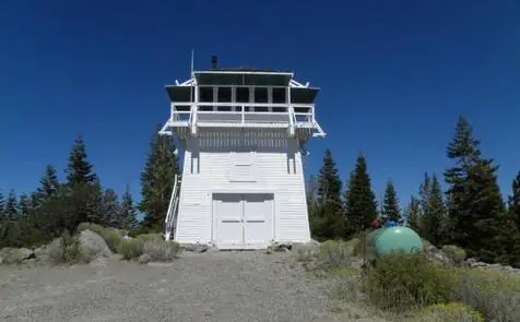
A 1935 CCC-built C-3 cab on a 17-ft tower in Tahoe National Forest, replacing a 1915 original, refurbished 2009 and now a rentable observation cab near Sierraville, CA.
- Standing
- Rentable
- Open to the public
- Verified
Visit & stay
You can rent this lookout for overnight stays through recreation.gov.
Overview Sardine Peak is a forest fire lookout tower that was constructed in 1935 by the Civilian Conservation Corps. It is a three story enclosed tower with external stairs. Presently the top room or observation cab is the only rentable space. Sardine sits at an elevation of 8,138 feet in the Eastern Sierra Nevada Mountains of Tahoe National Forest, approximately 20 miles from Truckee, California. The lookout does not have electricity, water or garbage service. It does have a propane tank to operate propane-powered appliances. Recreation Hiking, mountain biking and off road vehicle use are popular around this lookout. Stampede and Boca Reservoirs are nearby for fishing, boating and swimming. Facilities The interior of the cab is 14 feet long and 14 feet wide and contains two twin beds, a dry sink, a table and four chairs, two propane lights, a propane cast iron heat stove and a propane stove/oven for cooking. A limited assortment of cooking utensils, pots and pans are provided. There is an accessible vault toilet, a picnic table and fire ring are located outside below the lookout. Firewood is not provided. Visitors need to bring their own bedding, toilet paper and other personal items. Natural Features The lookout tower sits on a mountain top with spectacular views of Stampede Reservoir, Boca Reservoir, Sardine Valley, Independence Lake, the top of the Sierra Buttes and western Nevada. Nearby Attractions Kyburz Flat Interpretive Area, The Boca Townsite Interpretive Area, and a mountain bike loop within Sardine Valley are all nearby. Contact Info For facility specific information, please call (530) 430-8912.
Book on recreation.gov (opens recreation.gov)
Rental details from recreation.gov, checked 19 Oct 2026. Rules, fees and seasons change, so confirm on the booking page before you go. Data source: ridb.recreation.gov
Access
Open to the public. Reached via dirt/gravel Forest Service roads off Hwy 89; last quarter mile is a walk-in past a locked gate.
- Can you climb it?
- Yes
- Road to the top?
- No, you have to hike
- Trail
- Iron gate forces parking and a quarter-mile walk to the tower.
- Staffing
- Not staffed (as of 2026-10-04)
Facts
- Status
- Type
- Enclosed tower14'x14' C-3 cab on an enclosed 17-ft wood tower, built by the CCCThe designs: C-3, Plan 4-A
- Built of
- Not recorded
- Built
- 1915
- Height
- 300 ft (91.4 m)
- Elevation
- 8,135 ft (2,480 m)
- Agency
- U.S. Forest Service
- Land
- Federal land
- Location
- Sierra County, California
- Coordinates
- 39.54005, −120.18787
- Registers
- This entry
- VerifiedResearched, then checked independently. Updated 19 Oct 2026.
- Firefinder id
us-ca-sardine-peak
View from the cab
What you see from the cab: every ridge out to about 93 miles, the named peaks in sight, and other fire lookouts within view, worked out from terrain data in your browser.
Downloads about 3.1 MB of terrain data the first time.
Or see what it could see on the map: the ground in its line of sight.
History
Then and now
- 1915 BuiltFirst structure was a 4-A cab on an enclosed wood towerSource: nhlr.org
- No record between 1915 and 1935
- 1935 Built'Built' field on NHLR detail pageSource: NHLR register entry
- 1935 Replaced by a new structureCurrent 14'x14' C-3 cab on a 17-ft enclosed tower built by the CCC on the Tahoe National ForestSources: nhlr.org, recreation.gov
- No record between 1935 and 2004
- 2004 Added to the National Historic Lookout RegisterRegistered September 21, 2004 as NHLR US 596Source: nhlr.org
- 2009 RestoredRefurbished and made available for public rentalSource: nhlr.org
- 2010 Opened as a rentalNewly opened as a visitor rental by the Forest Service.Source: firelookout.org
- TodayStandingIt still stands, as far as our sources know.
Old maps of this spot
USGS topographic maps from the years a lookout stood may show it, often as a small symbol labelled “Lookout”. See the old topo maps around it on the Firefinder map, or find every scanned sheet of this spot on USGS TopoView (opens another site) (click the spot there to list them, with dates and downloads).
Story
Researched 4 Oct 2026, fact-checked.
The first lookout on Sardine Peak went up in 1915, a simple 4-A cab set on an enclosed wood tower overlooking the eastern Sierra Nevada.1 That structure didn't last as the Forest Service's standard; in 1935, the Civilian Conservation Corps rebuilt the site on the Tahoe National Forest with a 14-by-14-foot C-3 cab on a 17-foot enclosed tower.1,2 At about 8,100 feet in the Sierraville Ranger District, it looks out on the Sierra Buttes and Sierra Valley to the north and west, with Truckee visible to the north.1
Sardine Peak is not currently staffed, and the NHLR notes that nearby Babbitt Peak, about six miles northeast, carries the active lookout duty for the area now.1 Beyond that, little detail survives in the available record about who staffed Sardine Peak over the decades or what fires it watched for — a gap typical of lookouts that were retired from fire detection before systematic staffing records became easy to find online.
The tower survived long enough to be refurbished in 2009, and it's now part of the Forest Service's rental cabin program.1 Today only the top room, the observation cab, is rentable; it's furnished simply with two twin beds, a dry sink, a table and chairs, and propane lighting, heat, and cooking — there's no electricity or running water, and visitors haul in their own supplies.2 A vault toilet, picnic table, and fire ring sit below the tower.
Getting there means driving dirt and gravel Forest Service roads out of Truckee or Sierraville, manageable for most of the route in an ordinary low-clearance two-wheel-drive car, but a locked iron gate stops vehicles short, so the final quarter mile has to be covered on foot.1,2 Renters should call the Sierraville Ranger District ahead for road, weather, and fire-condition updates before heading out.2
- Sardine Peak Lookout, National Historic Lookout Register (nhlr.org), http://nhlr.org/lookouts/us/ca/sardine-peak-lookout/ (accessed 2026-10-04). ↩
- Sardine Peak Lookout Tower, Tahoe National Forest, Recreation.gov, https://www.recreation.gov/camping/campgrounds/252037 (accessed 2026-10-04). ↩
Photos
Photos keep their own rights and are shown with credit. Is one of these yours? You can ask for a different credit or for removal.
Sources
- National Historic Lookout Register (NHLR) (opens another site) Gave us: name, location, county, elevation, register numbers, agency, dates, photos, links National Historic Lookout Register (nhlr.org) · All rights reserved (American Resources, Inc.); facts extracted only, no prose copied. · retrieved 4 Oct 2026
- Forest Fire Lookout Association (FFLA) - US lookout lists (opens another site) Gave us: type, status, register numbers, links Forest Fire Lookout Association (firelookout.org) · No licence stated; facts extracted only, no prose copied. · retrieved 8 Oct 2026
- Recreation Information Database (recreation.gov) (opens another site) Gave us: ownership, access, rental details, links Data source: ridb.recreation.gov · Public data from the US government · retrieved 19 Oct 2026
- Forest Fire Lookout Association: lookout rentals (opens another site) Gave us: rental details, links Forest Fire Lookout Association rentals list (firelookout.org) · No licence stated; facts extracted only (state, name, booking link, manager, closure note), no prose copied. The FFLA says it is not involved in managing any rental program. · retrieved 19 Oct 2026
- Forest Fire Lookout Association chapter reports (opens another site) Gave us: dates, links Forest Fire Lookout Association, chapter and restoration-grant reports (firelookout.org) · No licence stated; facts only (dates, names, the kind of work done). Every note is our own wording and every event links to the FFLA report it comes from. Positions are copied from the NHLR, FFLOS and FFLA records. · retrieved 8 Oct 2026
- Wikidata -- US fire lookout towers (Q748998 and subclasses) (opens another site) Gave us: links Wikidata · CC0 1.0 (Wikidata). Images keep their own Commons licence/credit. · retrieved 4 Oct 2026
- FOREST LOOKOUTS -- western US (Ron Kemnow's weebly sites) (opens another site) Gave us: height, links Ron Kemnow's Forest Lookouts sites (westlookouts, californialookouts, idaholookouts, montanalookouts, oregonlookouts and washingtonlookouts .weebly.com) · No licence stated; facts only (county, land manager, status word, coordinates where the page's own map widget gives them, township-range-section, height and design hints, links). The site's own newspaper quotes, citations and narrative are not reproduced. · retrieved 8 Oct 2026
- Firefinder research Gave us: summary, design, status, agency, access, staffing, visiting details, dates, links, fact-check Firefinder research (sources cited in the story footnotes) · Our own research notes; each fact cites its source in the lookout's story
More about this lookout elsewhere
- NHLR register entry US 596 (nhlr.org) (opens another site)
- Recreation.gov listing (opens another site)
- FFLA California lookout list (firelookout.org) (opens another site)
- FFLA lookout rentals list (firelookout.org) (opens another site)
- Forest Fire Lookout Association chapter reports: work on Sardine Peak Lookout (opens another site)
- Sardine Peak on Forest Lookouts, western US (Ron Kemnow) (opens another site)
- Wikidata item Q86928720 (opens another site)
Firefinder takes facts (places, dates, numbers) from these sources and writes its own words. See all sources and licences.