Fire lookout · Humboldt County, California
Shelton Butte Lookout Site
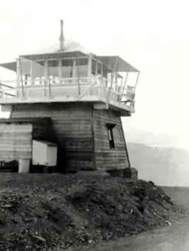
Six Rivers lookout built 1934 as a Plan BC-301 cabin on a 10-foot tower, staffed into the 1960s, now listed as gone; a 2008 post reported a radio tower on the site.
- Gone
- Access unknown
- Verified
Gone: The lookout no longer stands. Only the site is left. Lookout tower reported no longer there (2008 blog citing a book); the site then held a radio tower
Visit & stay
Gone: site only. The lookout no longer stands, so there is nothing to climb or rent.
Access
Access unknown
We do not know the access rules. Check with the land manager before you go.
- Road to the top?
- Unknown
Facts
- Status
- sources disagree
- Type
- Enclosed towerCalifornia Region 5 Plan BC-301 cabin on a 10 foot enclosed timber towerThe design: BC-301
- Built of
- Wood
- Also served as
- Aircraft Warning Service postDuring the Second World War it was staffed to spot and report aircraft.
- Built
- 1934
- Height
- 700 ft (213.4 m)
- Elevation
- 3,464 ft (1,056 m)
- Agency
- US Forest Service, Six Rivers National Forest
- Land
- Federal land
- Location
- Humboldt County, California
- Coordinates
- 41.23816, −123.63269
- Registers
- This entry
- VerifiedResearched, then checked independently. Updated 9 Oct 2026.
- Firefinder id
us-ca-shelton-butte
View from the cab
What the lookout saw from its cab: every ridge out to about 93 miles, the named peaks in sight, and other fire lookouts within view, worked out from terrain data in your browser.
This lookout is gone. The view is reconstructed from its recorded site and a typical height for a lookout like it.
Downloads about 3.7 MB of terrain data the first time.
Or see what it could see on the map: the ground in its line of sight.
History
Then and now
- 1934 BuiltFFLOS Built field gives 1934; a 1935 newspaper item shows the new lookout occupied by July 1935Sources: firetower.org, californialookouts.weebly.com
- 1935 StaffedPercy Starritt moved to the new Shelton Butte Lookout in July 1935 (Wilder Diary, as quoted on Forest Lookouts)Source: californialookouts.weebly.com
- 1942 EventUsed by the Aircraft Warning Service during the winter of 1942-1943Sources: firetower.org, californialookouts.weebly.com
- 1945 StaffedR.F. Lamberger replaced Edgar Warrington as lookout on July 25Source: californialookouts.weebly.com
- 1952 StaffedMrs. Ena Starritt working as relief lookoutSource: californialookouts.weebly.com
- 1958 StaffedHerbert Sonneborn and family moved to the lookout for the fire seasonSource: californialookouts.weebly.com
- 1959 StaffedJulius B. Starr named as the Shelton Butte lookoutSource: californialookouts.weebly.com
- 1962 StaffedLillian Taggart, wife of C.W. Taggart, was a fire lookout there, per a 1962 newspaper reportSource: californialookouts.weebly.com
- 1965 AlteredA temporary tower structure was being erected at the lookout; Robert Tillitz of Chico was manning itSource: californialookouts.weebly.com
- No record between 1965 and 2020
- 2020 Added to the Former Fire Lookout Sites RegisterRegistered with FFLOS on January 30, 2020 as US 1899, CA 94Source: firetower.org
- TodayGoneThe lookout no longer stands. Only the site is left. When it came down is not recorded.
Old maps of this spot
USGS topographic maps from the years a lookout stood may show it, often as a small symbol labelled “Lookout”. See the old topo maps around it on the Firefinder map, or find every scanned sheet of this spot on USGS TopoView (opens another site) (click the spot there to list them, with dates and downloads).
Story
Researched 9 Oct 2026, fact-checked.
Shelton Butte rises on the east side of the Klamath River, about six miles north-northeast of Weitchpec in Humboldt County, at 1,056 meters.1,2 The lookout there was built in 1934 as a California Region 5 Plan BC-301 cabin on a 10-foot enclosed timber tower, and the US Forest Service ran it through the Six Rivers National Forest.1 A 1941 survey description says the building was painted white, had a pyramidal roof and stood about 25 feet high, so the two height figures may describe different parts of the structure.2
A diary entry quoted on the Forest Lookouts site says Percy Starritt was moved into the new lookout in July 1935.2 During the winter of 1942 to 1943 the station was used by the Aircraft Warning Service during World War II.1,2 Later items name R.F. Lamberger, who replaced Edgar Warrington in 1945, Mrs. Ena Starritt as relief lookout in 1952, the Sonneborn family for the 1958 season, and Julius B. Starr, named to the post in 1959.2
In 1962 the Eureka Humboldt Standard reported that C.W. Taggart died when his car plunged down an embankment while he was traveling to visit his wife, a lookout on Shelton Butte.2 In 1965 a temporary tower structure was being erected at the lookout, and Robert Tillitz of Chico was manning it.2
The Former Fire Lookout Sites register gives the removal date as unknown.1 The Forest Fire Lookout Association lists the site as gone.3 A 2008 blog post, citing a book, said the lookout tower had gone.4
The same 2008 post described a radio tower on the site.4 An OpenStreetMap entry tags the site as a fire lookout, but that tag does not say whether anything stands there.5 No source we read describes the summit today or whether the public may visit it.
- Shelton Butte Lookout Site, Former Fire Lookout Sites, http://firetower.org/lookouts/us/ca/shelton-butte-lookout-site/ (accessed 2026-10-09). ↩
- Shelton Butte, Forest Lookouts, https://californialookouts.weebly.com/shelton-butte.html (accessed 2026-10-09). ↩
- California Lookouts, Forest Fire Lookout Association, https://firelookout.org/lookouts/us/ca/ (accessed 2026-10-09). ↩
- Northcoast Bike Rides: Fire Lookouts, Northcoast Bike Rides, https://northcoastbikerides.blogspot.com/2008/10/fire-lookouts.html (accessed 2026-10-09). ↩
- Way 1209454435: Shelton Butte Lookout, OpenStreetMap, https://www.openstreetmap.org/way/1209454435 (accessed 2026-10-09). ↩
Photos
Photos keep their own rights and are shown with credit. Is one of these yours? You can ask for a different credit or for removal.
Where sources disagree
We show disagreements between sources instead of quietly picking one. If you know which is right, please tell us.
Sources disagree on whether it still stands.
- FFLA: Gone
- FFLOS: Gone
- OpenStreetMap: Standing
Sources
- Former Fire Lookout Sites Register (FFLOS) (opens another site) Gave us: name, location, county, elevation, what it is built of, wartime use, register numbers, agency, ownership, dates, photos, links Former Fire Lookout Sites Register (firetower.org) · All rights reserved (American Resources, Inc.); facts extracted only, no prose copied. · retrieved 4 Oct 2026
- Forest Fire Lookout Association (FFLA) - US lookout lists (opens another site) Gave us: type, status, register numbers, links Forest Fire Lookout Association (firelookout.org) · No licence stated; facts extracted only, no prose copied. · retrieved 8 Oct 2026
- OpenStreetMap -- fire lookout structures (opens another site) Gave us: links © OpenStreetMap contributors · ODbL 1.0. (c) OpenStreetMap contributors. · retrieved 4 Oct 2026
- FOREST LOOKOUTS -- western US (Ron Kemnow's weebly sites) (opens another site) Gave us: height Ron Kemnow's Forest Lookouts sites (westlookouts, californialookouts, idaholookouts, montanalookouts, oregonlookouts and washingtonlookouts .weebly.com) · No licence stated; facts only (county, land manager, status word, coordinates where the page's own map widget gives them, township-range-section, height and design hints, links). The site's own newspaper quotes, citations and narrative are not reproduced. · retrieved 8 Oct 2026
- Firefinder research Gave us: summary, design, status, agency, dates, links, fact-check Firefinder research (sources cited in the story footnotes) · Our own research notes; each fact cites its source in the lookout's story
More about this lookout elsewhere
- FFLOS register entry US 1899 (firetower.org) (opens another site)
- Northcoast Bike Rides: Fire Lookouts (Northcoast Bike Rides (blog)) (opens another site)
- FFLA California lookout list (firelookout.org) (opens another site)
- Shelton Butte Lookout - Forest Lookouts Page (opens another site)
- OpenStreetMap way 1209454435 (opens another site)
Firefinder takes facts (places, dates, numbers) from these sources and writes its own words. See all sources and licences.