Fire lookout · Sierra County, California
Sierra Buttes Lookout
Tahoe NF cab reached by 176 stairs; register dates it 1963, but 1963 bids and a 1964 stair plaque complicate that; staffing history runs to 1992.
- Standing
- Open to the public
- Verified
Visit & stay
Not rentable. As far as we know, this lookout cannot be booked for overnight stays.
Access
Open to the public. Forest Service trail to the lookout is described and a 2024 visitor account climbed the stairs; no closure notice found in sources read. Current rules not confirmed.
- Can you climb it?
- Yes
- Road to the top?
- No, you have to hike
- Trail
- About 2.3 miles from a parking area off Forest Road 93-2 (Forest Service), no water at the trailhead, 176 stairs at the top (NHLR).
- Staffing
- Staffed during fire season (as of 1992)
Facts
- Status
- Type
- Two-story buildingCL-100 metal live-in cab on a stair-climbed summit (NHLR)The design: CL-100
- Built of
- Steel
- Built
- 1916
- Height
- Unknown
- Elevation
- 7,797 ft (2,377 m)
- Agency
- U.S. Forest Service, Tahoe National Forest
- Land
- Federal land
- Location
- Sierra County, California
- Coordinates
- 39.59355, −120.64693 sources disagree
- Registers
- This entry
- VerifiedResearched, then checked independently. Updated 8 Oct 2026.
- Firefinder id
us-ca-sierra-buttes
View from the cab
What you see from the cab: every ridge out to about 93 miles, the named peaks in sight, and other fire lookouts within view, worked out from terrain data in your browser.
Downloads about 3.7 MB of terrain data the first time.
Or see what it could see on the map: the ground in its line of sight.
History
Then and now
- 1908 EventSite first used for fire detectionSource: nhlr.org
- 1915 EventForest Service announced a standard lookout house, telephone line and trail (newspaper plans, not confirmed construction)Source: californialookouts.weebly.com
- 1916 Built12 by 12 ft cabin, per registerSource: nhlr.org
- 1920 StaffedMiss Rena Tomola to serve as summer lookoutSource: californialookouts.weebly.com
- 1926 FireNewspaper reported the station in danger from a forest fire near Sierra City (report based on telephone messages)Source: californialookouts.weebly.com
- 1933 Built9 by 9 cab on a 6 ft base, per registerSource: nhlr.org
- No record between 1933 and 1954
- 1954 FireFire destroyed a storehouse for the lookout tower; the tower itself is not reported destroyedSource: californialookouts.weebly.com
- 1963 BuiltRegister says current CL-100 cab went into service in 1963; Aug 1963 bids still being advertised for constructionSources: nhlr.org, californialookouts.weebly.com
- 1964 BuiltFive Tahoe NF employees attached stairs, rails and platforms in summer 1964 (plaque)Source: ukiahdailyjournal.com
- No record between 1964 and 1992
- 1992 StaffedSeason early July to end of September; Kenneth Ingle on 10 days on, four offSource: californialookouts.weebly.com
- 2004 Added to the National Historic Lookout RegisterDate registered per NHLR detail page: September 21, 2004Source: NHLR register entry
- TodayStandingIt still stands, as far as our sources know.
Old maps of this spot
USGS topographic maps from the years a lookout stood may show it, often as a small symbol labelled “Lookout”. See the old topo maps around it on the Firefinder map, or find every scanned sheet of this spot on USGS TopoView (opens another site) (click the spot there to list them, with dates and downloads).
Story
Researched 8 Oct 2026, fact-checked.
Sierra Buttes Lookout stands on a summit in Sierra County, in the Tahoe National Forest.1 Fire detection began on the site in 1908.1 By 1915 the Forest Service had announced a standard lookout house there, with a telephone line to Sierra City and a trail to the top.2
The register describes a 1916 cabin, a 1933 cab, and the current metal cab, which it dates to 1963.1 The other sources do not line up neatly with that date. A Forest Service bid notice from August 1963 was still inviting bids to build the lookout.2 A 1968 item says a contractor erected the present lookout.2 A plaque at the foot of the stairs credits five Tahoe National Forest employees with attaching the stairs and platforms to the peak in summer 1964.3 The 1963 date is the register's, and the building history is less settled than that date suggests.
Lookouts worked the summit in season. Miss Rena Tomola was set to serve as summer lookout in 1920.2 By 1939 Sam Kasper had been on the peak for five years.2 A 1992 item says the season ran from early July through September, with Kenneth Ingle working a ten-day stretch followed by four days off.2
Fire came close more than once. In August 1926 a newspaper reported that the lookout station was in danger from a forest fire near Sierra City.2 In 1954 a fire destroyed a storehouse for the lookout tower.2
The lookout still stands, and a 2024 newspaper visitor account describes fire-detection gear placed at the station over the years.3 The register counts 176 stairs to the top.1 The Forest Service describes the trail from a parking area off Forest Road 93-2 as about 2.3 miles and calls it challenging, with no water at the trailhead.4 The sources read do not confirm current staffing or visiting rules, so check with the Tahoe National Forest before you go.
- Sierra Buttes Lookout, National Historic Lookout Register, http://nhlr.org/lookouts/us/ca/sierra-buttes-lookout/ (accessed 2026-10-08). ↩
- Sierra Buttes - FOREST LOOKOUTS, Forest Lookouts, https://californialookouts.weebly.com/sierra-buttes.html (accessed 2026-10-08). ↩
- Climbing a staircase to the sky: Sierra Buttes Fire Lookout, Ukiah Daily Journal, https://www.ukiahdailyjournal.com/2024/09/20/climbing-a-staircase-to-the-sky-sierra-buttes-fire-lookout/ (accessed 2026-10-08). ↩
- Sierra Buttes Trail, USDA Forest Service, Tahoe National Forest, https://www.fs.usda.gov/r05/tahoe/recreation/trails/sierra-buttes-trail (accessed 2026-10-08). ↩
Photos
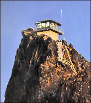
Photos keep their own rights and are shown with credit. Is one of these yours? You can ask for a different credit or for removal.
Where sources disagree
We show disagreements between sources instead of quietly picking one. If you know which is right, please tell us.
Sources disagree on the location by 560 m.
- FFLA: 39.59355, −120.64693
- NHLR: 39.59542, −120.64083
They share a register number.
The map uses the position from FFLA.
Sources
- National Historic Lookout Register (NHLR) (opens another site) Gave us: name, county, elevation, what it is built of, register numbers, agency, ownership, dates, photos, links National Historic Lookout Register (nhlr.org) · All rights reserved (American Resources, Inc.); facts extracted only, no prose copied. · retrieved 4 Oct 2026
- Forest Fire Lookout Association (FFLA) - US lookout lists (opens another site) Gave us: location, type, status, register numbers, links Forest Fire Lookout Association (firelookout.org) · No licence stated; facts extracted only, no prose copied. · retrieved 8 Oct 2026
- OpenStreetMap -- fire lookout structures (opens another site) Gave us: links © OpenStreetMap contributors · ODbL 1.0. (c) OpenStreetMap contributors. · retrieved 4 Oct 2026
- FOREST LOOKOUTS -- western US (Ron Kemnow's weebly sites) (opens another site) Gave us: links Ron Kemnow's Forest Lookouts sites (westlookouts, californialookouts, idaholookouts, montanalookouts, oregonlookouts and washingtonlookouts .weebly.com) · No licence stated; facts only (county, land manager, status word, coordinates where the page's own map widget gives them, township-range-section, height and design hints, links). The site's own newspaper quotes, citations and narrative are not reproduced. · retrieved 8 Oct 2026
- Firefinder research Gave us: summary, design, status, agency, access, staffing, visiting details, dates, links, fact-check Firefinder research (sources cited in the story footnotes) · Our own research notes; each fact cites its source in the lookout's story
More about this lookout elsewhere
- NHLR register entry US 594 (nhlr.org) (opens another site)
- Climbing a staircase to the sky: Sierra Buttes Fire Lookout (Ukiah Daily Journal) (opens another site)
- Sierra Buttes Trail (USDA Forest Service, Tahoe National Forest) (opens another site)
- FFLA California lookout list (firelookout.org) (opens another site)
- Sierra Buttes on Forest Lookouts, western US (Ron Kemnow) (opens another site)
- OpenStreetMap node 12271558995 (opens another site)
Firefinder takes facts (places, dates, numbers) from these sources and writes its own words. See all sources and licences.