Fire lookout · Shasta County, California
South Fork Mountain Lookout Site
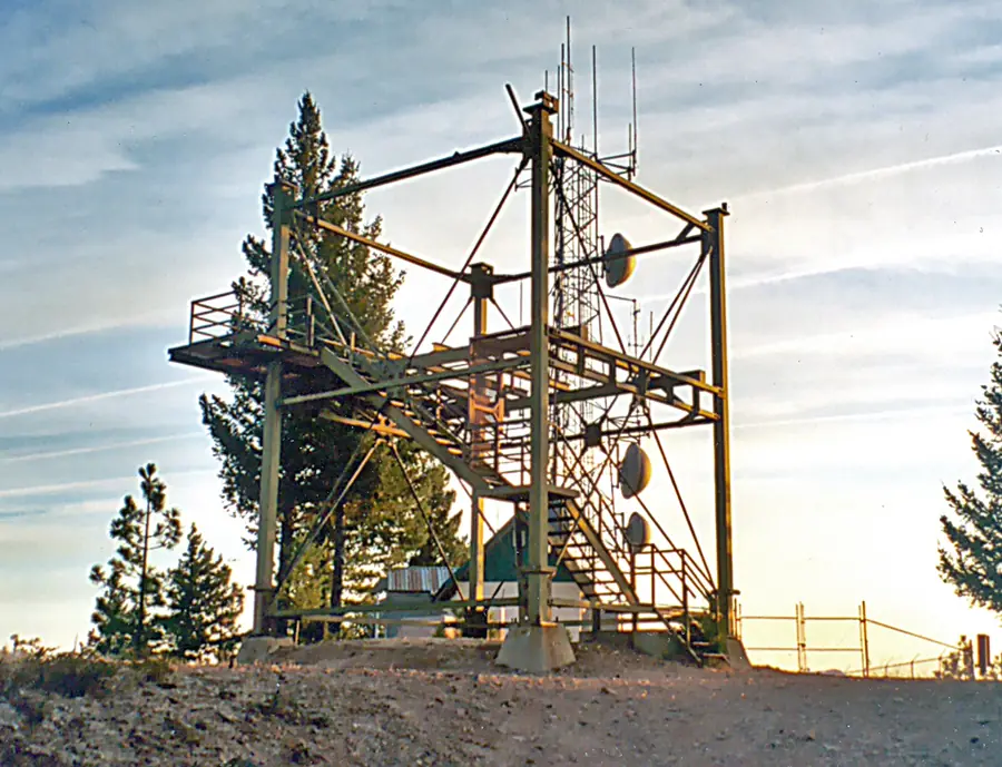
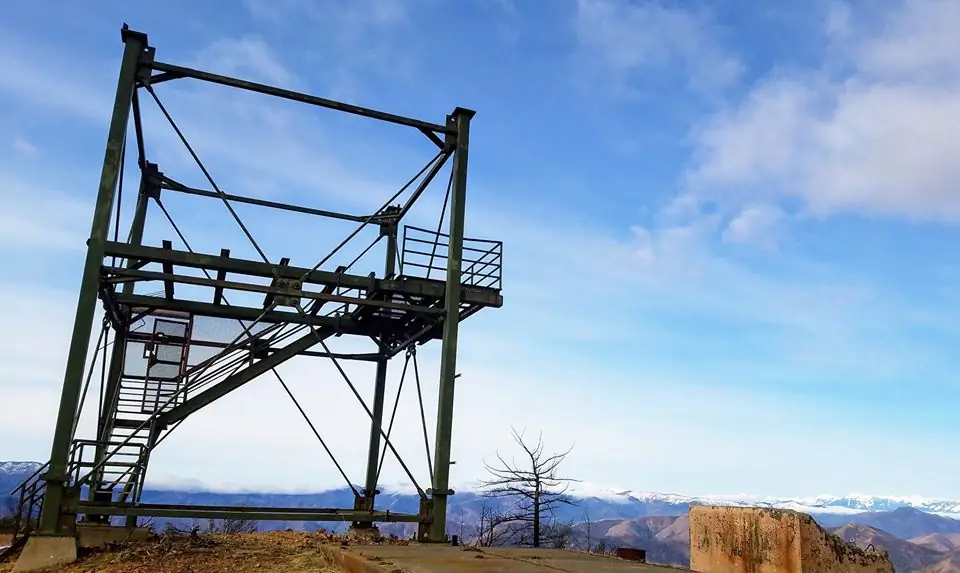
Shasta County steel tower the register dates to 1982, designed by CDF engineer Mike Plesha; the sources disagree on whether a lookout still stands, and the site is now a radio and repeater site.
- Standing
- Open to the public
- Verified
Standing: The tower still stands, but its cab is gone (FFLA).
Visit & stay
Not rentable. As far as we know, this lookout cannot be booked for overnight stays.
Access
Open to the public. Register (1991 access note) says the site is accessible to the public, 6.7 miles from paved road. Radio site with very high electromagnetic radiation near the catwalk; do not climb.
- Can you climb it?
- Unknown
- Road to the top?
- Unknown
- Staffing
- Unknown
Facts
- Status
- sources disagree
- Type
- Cab on a towerCDF Plan No. 1559-2A steel tower with a 732-6A Plesha-design cab; hollow steel legs originally intended for atomic test towersThe design: CDF 732-6A
- Built of
- Steel
- Built
- 1982
- Height
- Unknown
- Elevation
- 3,450 ft (1,052 m)
- Agency
- California Department of Forestry and Fire Protection, Shasta-Trinity Unit (Cal Fire)
- Land
- Unknown
- Location
- Shasta County, California
- Coordinates
- 40.65409, −122.52500
- Registers
- This entry
- VerifiedResearched, then checked independently. Updated 9 Oct 2026.
- Firefinder id
us-ca-south-fork-mountain
View from the cab
What you see from the cab: every ridge out to about 93 miles, the named peaks in sight, and other fire lookouts within view, worked out from terrain data in your browser.
Downloads about 3.5 MB of terrain data the first time.
Or see what it could see on the map: the ground in its line of sight.
History
Then and now
- 1977 StaffedNewspaper item quoted by Forest Lookouts: a south-fork lookout north of Whiskeytown Lake to be manned beginning SaturdaySource: californialookouts.weebly.com
- 1982 BuiltRegister: South Fork Mountain was constructed in 1982Source: firetower.org
- 1985 EventCEQA notice of exemption: renewal of a permit for Pacific Bell to use an access road to the siteSource: ceqanet.lci.ca.gov
- 1994 AlteredCEQA notice of exemption: replacement of a 60-foot wooden four-pole antenna tower at the siteSource: ceqanet.lci.ca.gov
- No record between 1994 and 2012
- 2012 EventFFLA Northern California chapter report: South Fork no longer exists; listed as a repeater siteSource: firelookout.org
- 2019 Added to the Former Fire Lookout Sites RegisterDate registered per FFLOS detail page: December 29, 2019Source: FFLOS register entry
- TodayStandingIt still stands, as far as our sources know.
Old maps of this spot
USGS topographic maps from the years a lookout stood may show it, often as a small symbol labelled “Lookout”. See the old topo maps around it on the Firefinder map, or find every scanned sheet of this spot on USGS TopoView (opens another site) (click the spot there to list them, with dates and downloads).
Story
Researched 9 Oct 2026, fact-checked.
The South Fork Mountain lookout site is in Shasta County, in rugged country north of the Whiskeytown-Shasta-Trinity National Recreation Area, at about 3,450 feet (1,052 meters).1 The register gives 1982 as the year it was constructed.1
The design came from the state forestry service. The register credits CDF engineer Mike Plesha with the tower design, Plan No. 1559-2A.1 Its legs are hollow steel columns first meant for atomic bomb test towers built above ground. When those tests stopped, the General Services Administration sold off the leftover material, and this was the third CDF tower built from it.1 The cab is a Plesha design, the 732-6A.1
The 1982 date may not be the first word on the site. A 1977 item from The Intermountain News, quoted on the Forest Lookouts page, says a lookout on the south fork, north of Whiskeytown Lake, would be staffed starting Saturday.2 The sources we read do not say whether an earlier lookout stood on this peak, or whether the 1977 item meant another one.
The later record is thinner. In 1985 a CAL FIRE notice of exemption concerns renewing a permit that let Pacific Bell use an access road to the site.3 A 1994 notice describes replacing a 60-foot wooden, four-pole antenna tower there.4 A 2012 Northern California chapter report from the Forest Fire Lookout Association lists South Fork as no longer existing and as a repeater site.5 The association's California list still marks the tower Standing*. Its key defines that asterisk as a tower whose cab is no longer in place.6
The register's own text does not agree with itself. It says a repeater antenna is attached to the cab, but also that the cabin and storage structure went at an unknown date, leaving only the tower.1 The list's cab reading adds to the conflict.6 We could not settle which is current.
Today the register says the public can reach the site, which lies 6.7 miles from paved road, though that access note dates from 1991.1 It also cautions that the radiation level is very high near the lookout catwalk.1 We advise against climbing the tower. Ask the Cal Fire Shasta-Trinity unit about the site before any visit.
- South Fork Mountain Lookout Site, Former Fire Lookout Sites Register, http://firetower.org/lookouts/us/ca/south-fork-mountain-lookout-site/ (accessed 2026-10-09). ↩
- South Fork Mountain, Forest Lookouts, https://californialookouts.weebly.com/south-fork-mountain.html (accessed 2026-10-09). ↩
- South Fork Mountain Lookout, CEQAnet notice of exemption (1985), https://ceqanet.lci.ca.gov/1985031735 (accessed 2026-10-09). ↩
- South Fork Mountain RVL Antenna Tower Replacement, CEQAnet notice of exemption (1994), https://ceqanet.lci.ca.gov/1994106761 (accessed 2026-10-09). ↩
- Forest Fire Lookout Association Northern California Chapter Report 2012, Forest Fire Lookout Association, https://firelookout.org/wp-content/uploads/2024/11/cr-nca-2012.pdf (accessed 2026-10-09). ↩
- California lookouts, Forest Fire Lookout Association, https://firelookout.org/lookouts/us/ca/ (accessed 2026-10-09). ↩
Photos
Photos keep their own rights and are shown with credit. Is one of these yours? You can ask for a different credit or for removal.
Where sources disagree
We show disagreements between sources instead of quietly picking one. If you know which is right, please tell us.
Sources disagree on whether it still stands.
- FFLA: Standing
- FFLOS: Gone
Sources
- Former Fire Lookout Sites Register (FFLOS) (opens another site) Gave us: name, location, county, elevation, what it is built of, register numbers, agency, dates, photos, links Former Fire Lookout Sites Register (firetower.org) · All rights reserved (American Resources, Inc.); facts extracted only, no prose copied. · retrieved 4 Oct 2026
- Forest Fire Lookout Association (FFLA) - US lookout lists (opens another site) Gave us: type, status, register numbers, links Forest Fire Lookout Association (firelookout.org) · No licence stated; facts extracted only, no prose copied. · retrieved 8 Oct 2026
- FOREST LOOKOUTS -- western US (Ron Kemnow's weebly sites) (opens another site) Ron Kemnow's Forest Lookouts sites (westlookouts, californialookouts, idaholookouts, montanalookouts, oregonlookouts and washingtonlookouts .weebly.com) · No licence stated; facts only (county, land manager, status word, coordinates where the page's own map widget gives them, township-range-section, height and design hints, links). The site's own newspaper quotes, citations and narrative are not reproduced. · retrieved 8 Oct 2026
- Firefinder research Gave us: summary, design, agency, access, dates, links, fact-check Firefinder research (sources cited in the story footnotes) · Our own research notes; each fact cites its source in the lookout's story
More about this lookout elsewhere
- FFLOS register entry US 1884 (firetower.org) (opens another site)
- South Fork Mountain Lookout (CEQA notice of exemption, 1985) (CEQAnet (ceqanet.lci.ca.gov)) (opens another site)
- South Fork Mountain RVL Antenna Tower Replacement (CEQA notice of exemption, 1994) (CEQAnet (ceqanet.lci.ca.gov)) (opens another site)
- Forest Fire Lookout Association Northern California Chapter Report 2012 (opens another site)
- FFLA California lookout list (firelookout.org) (opens another site)
- South Fork Mountain Lookout - Forest Lookouts Page (opens another site)
Firefinder takes facts (places, dates, numbers) from these sources and writes its own words. See all sources and licences.