Fire lookout · Modoc County, California
Sugar Hill Lookout
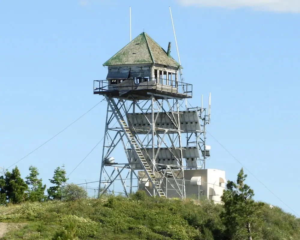
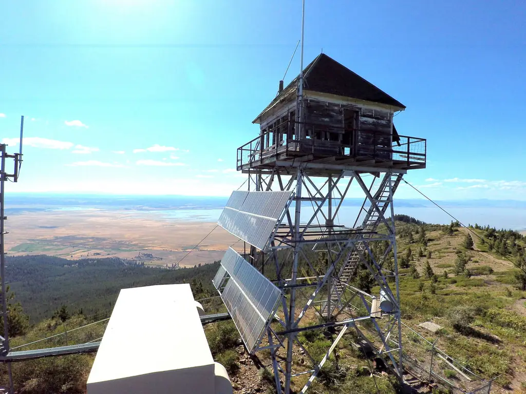
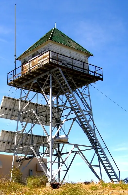
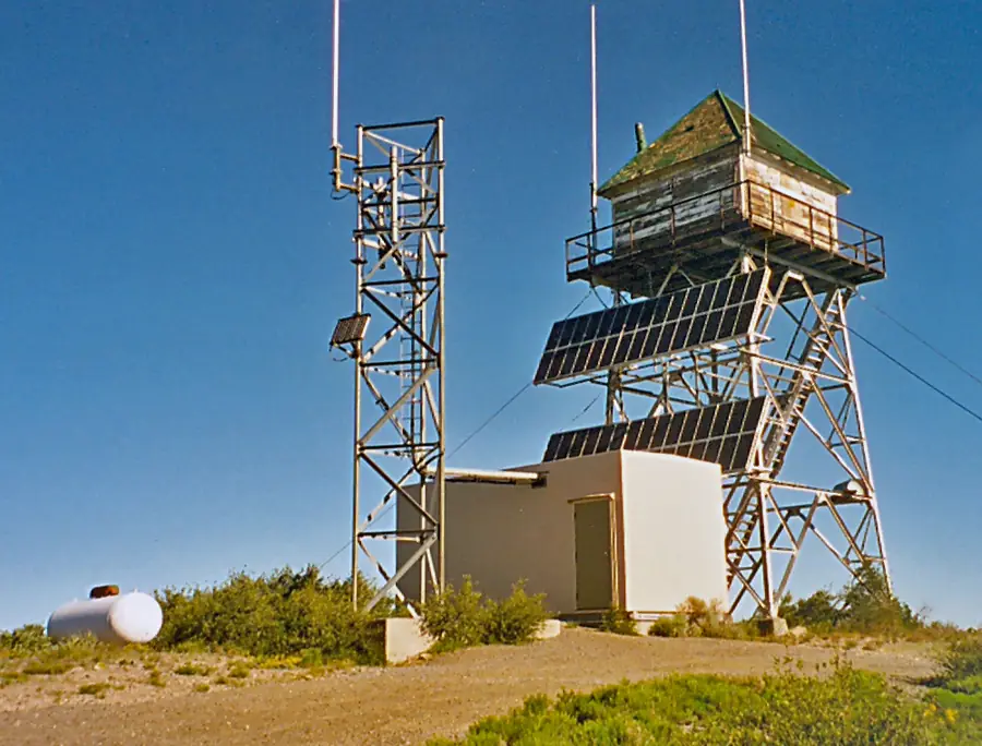
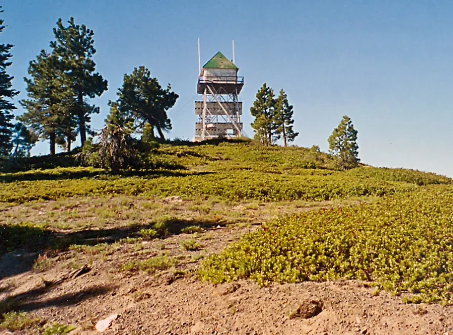
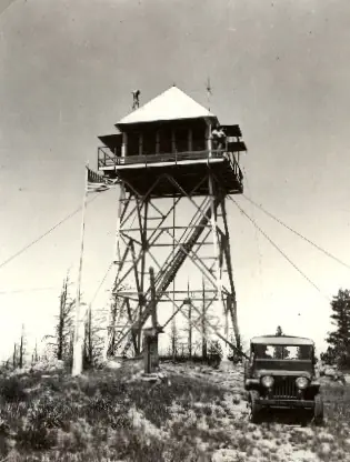
Modoc NF lookout: 1930 steel tower (30 ft, Region 5 4AR design) on a new Forest Service road; 1940 fire and 2001 vandalism; 2025 relocation or restoration talks ongoing.
- Standing
- Access unknown
- Verified
Visit & stay
Not rentable. As far as we know, this lookout cannot be booked for overnight stays.
Access
Access unknown
We do not know the access rules. Check with the land manager before you go.
- Can you climb it?
- Unknown
- Road to the top?
- Unknown
- Trail
- No source read confirms public access or the road's status today; the 1930 road was built to give auto access to the summit
- Staffing
- Unknown
Facts
- Status
- Type
- Cab on a towerCalifornia Region 5 4AR design on a 30-foot steel tower, with an all-glass cab (NHLR; 1932 newspaper)The design: D-5 (4-AR)
- Built of
- Not recorded
- Built
- 1930
- Height
- 30 ft (9.1 m)
- Elevation
- 7,276 ft (2,218 m)
- Agency
- US Forest Service - Modoc National Forest
- Land
- Federal land
- Location
- Modoc County, California
- Coordinates
- 41.80396, −120.32655
- Registers
- This entry
- VerifiedResearched, then checked independently. Updated 8 Oct 2026.
- Firefinder id
us-ca-sugar-hill
View from the cab
What you see from the cab: every ridge out to about 93 miles, the named peaks in sight, and other fire lookouts within view, worked out from terrain data in your browser.
Downloads about 3.8 MB of terrain data the first time.
Or see what it could see on the map: the ground in its line of sight.
History
Then and now
- 1929 FireSugar hill fire burned over 8,000 acres of timber; forest lookout D.M. Miller was dazed by smoke and wandered for hoursSource: californialookouts.weebly.com
- 1930 BuiltWork on the steel tower began September 1930; NHLR gives 1930/31Sources: nhlr.org, californialookouts.weebly.com
- 1930 EventForest Service road to the summit completed by July 1930, giving auto access; the summit had been reached only by a steep pack trailSource: californialookouts.weebly.com
- 1931 Replaced by a new structureSteel tower in service; it replaced a tree platform that had served for about a decadeSources: nhlr.org, californialookouts.weebly.com
- 1931 StaffedKeith Wells stationed on the lookout since June 1931, per a January 1932 newspaperSource: californialookouts.weebly.com
- 1933 EventForest Service telephone line under construction from a camp to the Sugar Hill lookoutSource: californialookouts.weebly.com
- 1940 FireHess Ranch fire in July 1940 spread into the old 1929 burn; the lookout had to be removed from the towerSource: californialookouts.weebly.com
- 1944 EventForest Service plan lists a standard lookout on a tower, with garage and woodshed, water storage and latrineSource: californialookouts.weebly.com
- 1953 Condition assessmentGeneral inspection: shutters and catwalk should be replaced because of dry rotSource: californialookouts.weebly.com
- No record between 1953 and 2001
- 2001 EventVandals broke the windows, pulled off wooden shutters, and destroyed the furniture and most of the interior paneling (reported June 27, 2001)Source: californialookouts.weebly.com
- 2007 Condition assessmentPhoto caption: fair condition; wooden cab needs repair and paint, steel tower goodSource: peakbagging.com
- 2019 Added to the National Historic Lookout RegisterRegistered October 23, 2019 as US 1331, CA 154Source: nhlr.org
- 2025 Condition assessmentReport author met forest staff at the lookout; relocation or restoration ideas discussed; project status ongoingSource: firelookout.org
- TodayStandingIt still stands, as far as our sources know.
Old maps of this spot
USGS topographic maps from the years a lookout stood may show it, often as a small symbol labelled “Lookout”. See the old topo maps around it on the Firefinder map, or find every scanned sheet of this spot on USGS TopoView (opens another site) (click the spot there to list them, with dates and downloads).
Story
Researched 8 Oct 2026, fact-checked.
Sugar Hill is a lookout on a peak just east of Goose Lake, in the North Warner district of the Modoc National Forest in Modoc County.1,2 The Forest Service runs it, and the steel tower still stands.1,3
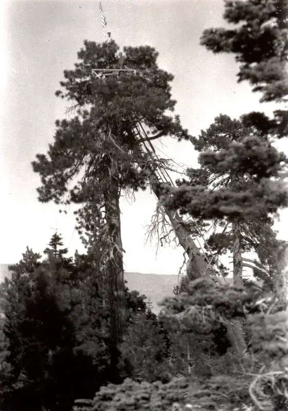
A tree-top lookout stood on the summit before the steel tower.2 For about a decade, its platform was built into the top of a large pine, and a felled tree leaning against the trunk served as the ladder.2 In 1930 the Forest Service built a road to the summit, which had until then been reached by a steep pack trail.2 That September work began on a steel tower planned at 30 feet high.2 The register dates the tower to 1930 or 1931 and calls its design a rare California Region 5 type.1
By early 1932 a newspaper described the tower as a recent design with an all-glass room, and said a lookout named Keith Wells had been posted there since the previous June.2
Fire touched the mountain more than once.2 In July 1929 the Sugar hill fire burned more than 8,000 acres of timber, and a forest lookout named D.M. Miller was dazed by the smoke and wandered for several hours before he met a fire crew.2 In July 1940 a fire that started at the Hess Ranch after a burn had not been fully put out raced up the slope and into the old 1929 burn. It was so hot that the lookout had to be taken off the tower.2
Later records describe wear and damage.1,2 A 1944 Forest Service plan listed a standard lookout on a tower, with a garage, woodshed, water storage and a latrine.2 A 1953 inspection flagged dry rot in the shutters and catwalk.2 In June 2001 vandals pulled off the shutters, broke the windows, and wrecked the furniture and much of the interior paneling.2 A 2007 photo caption rated the lookout in fair condition, with the wooden cab needing paint and repair while the steel tower looked good.4 The register says the cabin is open to the weather and deteriorating.1
A 2025 report from the Forest Fire Lookout Association says its author met forest staff at the lookout to talk about relocation or restoration.5 The project status is listed as ongoing.5
Today the lookout is listed as standing.3 The sources read do not say whether the public may go up, or whether the road is open now. A 2007 caption said volunteers might staff it in summer, but that note is nearly twenty years old.4 Check with the Modoc National Forest before planning a trip, and do not climb the tower unless the Forest Service says it is open.
- Sugar Hill Lookout, National Historic Lookout Register (nhlr.org), http://nhlr.org/lookouts/us/ca/sugar-hill-lookout/ (accessed 2026-10-08). ↩
- Sugar Hill, Forest Lookouts (californialookouts.weebly.com), https://californialookouts.weebly.com/sugar-hill.html (accessed 2026-10-08). ↩
- California lookout list, Forest Fire Lookout Association (firelookout.org), https://firelookout.org/lookouts/us/ca/ (accessed 2026-10-08). ↩
- Sugar Hill Lookout, Peakbagging (peakbagging.com), http://www.peakbagging.com/CALookoutPhotos/SugarHill.html (accessed 2026-10-08). ↩
- 2025 Cal-North Report (PDF), Forest Fire Lookout Association (firelookout.org), https://firelookout.org/wp-content/uploads/2026/01/cr-cal-north-2025.pdf (accessed 2026-10-08). ↩
Photos
Photos keep their own rights and are shown with credit. Is one of these yours? You can ask for a different credit or for removal.
Sources
- National Historic Lookout Register (NHLR) (opens another site) Gave us: name, location, county, elevation, register numbers, agency, ownership, dates, photos, links National Historic Lookout Register (nhlr.org) · All rights reserved (American Resources, Inc.); facts extracted only, no prose copied. · retrieved 4 Oct 2026
- Forest Fire Lookout Association (FFLA) - US lookout lists (opens another site) Gave us: type, status, register numbers, links Forest Fire Lookout Association (firelookout.org) · No licence stated; facts extracted only, no prose copied. · retrieved 8 Oct 2026
- FOREST LOOKOUTS -- western US (Ron Kemnow's weebly sites) (opens another site) Gave us: height, links Ron Kemnow's Forest Lookouts sites (westlookouts, californialookouts, idaholookouts, montanalookouts, oregonlookouts and washingtonlookouts .weebly.com) · No licence stated; facts only (county, land manager, status word, coordinates where the page's own map widget gives them, township-range-section, height and design hints, links). The site's own newspaper quotes, citations and narrative are not reproduced. · retrieved 8 Oct 2026
- Firefinder research Gave us: summary, design, height, status, agency, visiting details, dates, links, fact-check Firefinder research (sources cited in the story footnotes) · Our own research notes; each fact cites its source in the lookout's story
More about this lookout elsewhere
- NHLR register entry US 1331 (nhlr.org) (opens another site)
- Sugar Hill Lookout, California (Peakbagging (peakbagging.com)) (opens another site)
- 2025 Cal-North Report (PDF) (Forest Fire Lookout Association (firelookout.org)) (opens another site)
- FFLA California lookout list (firelookout.org) (opens another site)
- Sugar Hill on Forest Lookouts, western US (Ron Kemnow) (opens another site)
Firefinder takes facts (places, dates, numbers) from these sources and writes its own words. See all sources and licences.