Fire lookout · Fannin County, Georgia
Brawley Mountain Lookout Tower
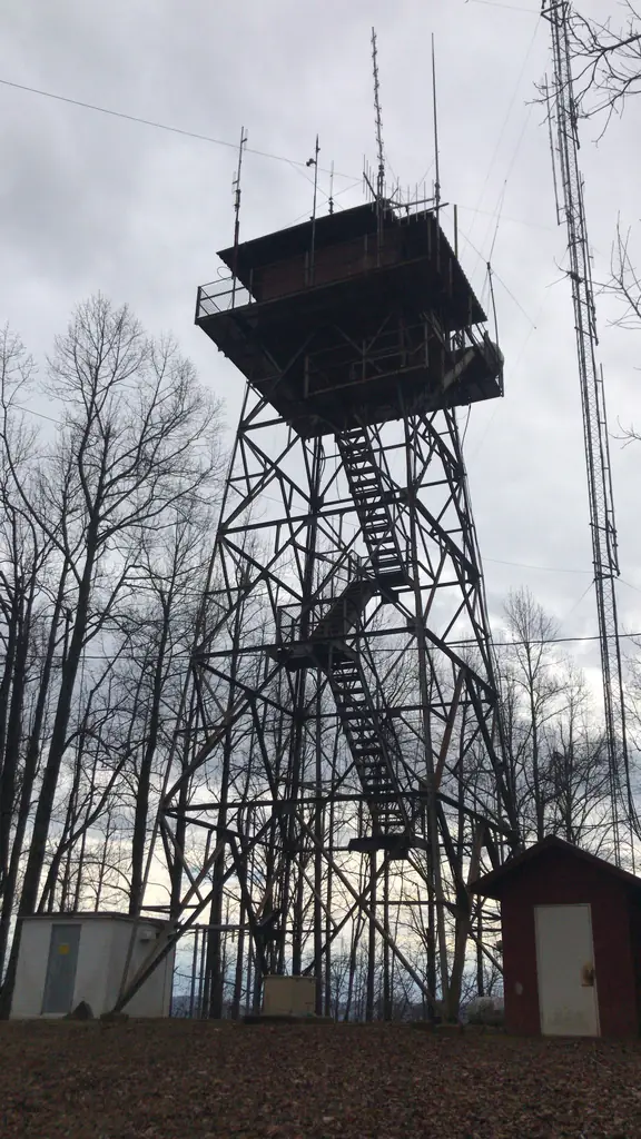
Steel fire tower on Brawley Mountain in Fannin County, no longer manned, closed to the public and used for antennas; build date not found.
- Standing
- Closed
- Verified
Closed
The site is closed to visitors. First flight of steps removed to prevent access; N2Backpacking says it is no longer accessible to the public.
Visit & stay
Not rentable. As far as we know, this lookout cannot be booked for overnight stays.
Access
Closed. See the warning at the top of this page.
- Can you climb it?
- No
- Road to the top?
- Unknown
- Trail
- About 3.2 miles from Wilscot Gap on the Benton MacKaye Trail; a gated forest road (FR 45) also leads to the tower.
- Staffing
- Unknown
Facts
- Status
- Type
- Cab on a tower50-foot steel tower with a 13-by-13-foot metal live-in cab, catwalk and flat roofThe design: CL-100
- Built of
- Not recorded
- Built
- Unknown
- Height
- 50 ft (15.2 m)
- Elevation
- 3,060 ft (933 m)
- Agency
- U.S. Forest Service (Chattahoochee National Forest)
- Land
- Federal land
- Location
- Fannin County, Georgia
- Coordinates
- 34.80222, −84.21415
- Registers
- This entry
- VerifiedResearched, then checked independently. Updated 8 Oct 2026.
- Firefinder id
us-ga-brawley-mountain
View from the cab
What you see from the cab: every ridge out to about 93 miles, the named peaks in sight, and other fire lookouts within view, worked out from terrain data in your browser.
Downloads about 3.0 MB of terrain data the first time.
Or see what it could see on the map: the ground in its line of sight.
History
Then and now
- 2019 Added to the National Historic Lookout RegisterRegistered on the National Historic Lookout Register February 19, 2019Source: nhlr.org
- 2021 EventForest Service scoping for a proposed radio site beside the tower began July 28, 2021; the project is now marked CancelledSource: fs.usda.gov
- TodayStandingIt still stands, as far as our sources know.
Old maps of this spot
USGS topographic maps from the years a lookout stood may show it, often as a small symbol labelled “Lookout”. See the old topo maps around it on the Firefinder map, or find every scanned sheet of this spot on USGS TopoView (opens another site) (click the spot there to list them, with dates and downloads).
Story
Researched 9 Oct 2026, fact-checked.
Brawley Mountain's lookout is a 50-foot steel tower with a 13-by-13-foot metal cab, a catwalk and a flat roof, standing in Fannin County, Georgia, inside the Chattahoochee National Forest.1 The U.S. Forest Service administers it.1 No source I could reach gives a build year or names the designer, so the tower's construction history is a gap in the record.1,2,3,4
Its original job has ended. The Mountain Travel Guide says the tower is no longer manned, because aircraft now handle fire detection during the spring and fall seasons.3 The tower has taken on a communications role instead. The register says it carries antennas for Fannin County EMS and TVA, and that its cab is falling into disrepair.1
In 2021 the Forest Service began scoping a proposed radio site on Brawley Mountain, beside the tower. The project is now marked as cancelled.4
The sources I found describe the tower as closed to the public. According to the register, the lowest flight of steps has been taken away to block access, and N2Backpacking says the tower is no longer accessible to the public.1,2 The register entry dates from 2019 and the N2Backpacking page is undated, so confirm with the Forest Service before treating this as current. The N2Backpacking guide describes a 3.2-mile hike from Wilscot Gap on the Benton MacKaye Trail, and notes that a gated forest road also leads to the tower.2 Enjoy the walk, but please leave the tower alone.
- Brawley Mountain Lookout Tower, National Historic Lookout Register, http://nhlr.org/lookouts/us/ga/brawley-mountain-lookout-tower/ (accessed 2026-10-09). ↩
- Brawley Mountain, N2Backpacking, https://n2backpacking.com/hikes/georgia/brawley-mountain/ (accessed 2026-10-09). ↩
- Brawley Mountain Loop Trail, Mountain Travel Guide, https://www.mountaintravelguide.com/Hiking%20Trails/georgia/fannin/Brawley%20Mountain%20Loop.htm (accessed 2026-10-09). ↩
- Gunby Communications Inc. Special Use Permit, project 60611, U.S. Forest Service, https://www.fs.usda.gov/r08/chattahoochee-oconee/projects/60611 (accessed 2026-10-09). ↩
Photos
Photos keep their own rights and are shown with credit. Is one of these yours? You can ask for a different credit or for removal.
Sources
- National Historic Lookout Register (NHLR) (opens another site) Gave us: name, location, county, elevation, type, status, register numbers, agency, ownership, dates, photos, links National Historic Lookout Register (nhlr.org) · All rights reserved (American Resources, Inc.); facts extracted only, no prose copied. · retrieved 4 Oct 2026
- tnlandforms.us fire lookout towers (Tom Dunigan) -- GA, NC, TN (opens another site) Gave us: links tnlandforms.us (Tom Dunigan) · No licence stated; facts only (coordinates, county, elevation, NGS/GFC/BLL register cross-references, status where given). · retrieved 4 Oct 2026
- Firefinder research Gave us: summary, design, height, status, agency, access, visiting details, dates, links, fact-check Firefinder research (sources cited in the story footnotes) · Our own research notes; each fact cites its source in the lookout's story
More about this lookout elsewhere
- NHLR register entry US 1290 (nhlr.org) (opens another site)
- Brawley Mountain (N2Backpacking) (opens another site)
- Brawley Mountain Loop Trail, Fannin County Georgia Hiking Trails (Mountain Travel Guide) (opens another site)
- Gunby Communications Inc. Special Use Permit (project 60611) (U.S. Forest Service, Chattahoochee-Oconee National Forest) (opens another site)
- Brawley Mountain Lookout Tower (tnlandforms.us (Tom Dunigan)) (opens another site)
Firefinder takes facts (places, dates, numbers) from these sources and writes its own words. See all sources and licences.