Fire lookout · Shoshone County, Idaho
Arid Peak Lookout
A 1934 railroad-fire lookout on the Milwaukee Road line, unstaffed after 1969, restored by volunteers in 1996-97 and now a rental.
- Standing
- Rentable
- Open to the public
- Verified
Visit & stay
You can rent this lookout for overnight stays through recreation.gov.
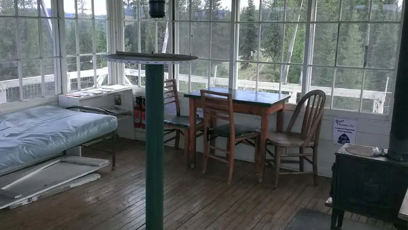
Overview Arid Peak Lookout was built in 1934 to help detect fires that may have been sparked by the Milwaukee Railroad Line. It was last staffed in 1969 and sat idle for over 25 years before being renovated by a team of over 30 volunteers, the Forest Fire Lookout Association and the U.S. Forest Service. Arid Peak Lookout was restored to its original splendor in 1997 and is available for rent to the public. The lookout is listed on the National Register of Historic Lookouts and provides epic 360 degree views of the Bitterroot Mountains. Access to the cabin requires a moderately-steep 3 mile hike and availability is dependent on weather conditions. Recreation The Hiawatha Bicycle Trail is considered the "crown jewel" of rail-to-trail mountain biking trails as it zips across seven trestles and through 10 tunnels in the magnificent Bitterroot Mountains. The trail can be accessed just over 10 miles from the lookout. The lookout offers access to the Arid Peak Trail #173, Mozier Peak Trail #174, and Kyle Creek Trail #175. All three trails are great for day-hiking, but can also be explored over longer backpacking treks or on horseback. Facilities The cabin fits up to four guests. Furnishings include two cots with mattresses, basic cooking gear, dishes, a propane lantern, propane camp stove, water containers, a table with two chairs and a wood stove. An outhouse is located outside the tower. No water is available so guests must bring their own or boil and treat stream water. Propane canisters are not included; a stock of 16.4 ounce canisters are required to use cooking and lighting equipment. Other items to pack include bedding, food, binoculars, a first aid kit, flashlights, towels, toilet paper, and dish soap. Natural Features The Arid Peak Lookout is located within the St. Joe River area of the Idaho Panhandle National Forests, an area that includes most of what was originally established as the St. Joe National Forest. The area is known for its blue-ribbon cutthroat trout streams, Wild and Scenic Rivers and extensive roadless and primitive areas. The St. Joe Rover area is also nationally recognized for its elk herds. The 20 foot tower sits at an elevation of 5,306 feet and overlooks the beautiful Loop Creek area and the scenic Hiawatha Bicycle Trail. The mixed conifer forest around the facility includes Douglas fir and spruce. Wildlife sightings of elk, deer, black bears, moose and bald eagles are common. This is bear country; Visitors are advised to be aware of and practice bear safety. Contact Info For facility specific information, please call (208) 245-2531. Nearby Attractions The town of Avery has the nearest conveniences.
Noted: Maintenance Closure 2026
This comes from the Forest Fire Lookout Association’s rentals list. Check with the manager or the booking page before you plan a stay.
Book on recreation.gov (opens recreation.gov)
Rental details from recreation.gov, checked 19 Oct 2026. The closure note comes from the Forest Fire Lookout Association’s rentals list. Rules, fees and seasons change, so confirm on the booking page before you go. Data source: ridb.recreation.gov
Access
Open to the public. Forest Service rental lookout, booked via Recreation.gov; moderately steep 3-mile hike in
- Can you climb it?
- Yes
- Road to the top?
- No, you have to hike
- Trail
- 3-mile hike, availability weather dependent
- Staffing
- Not staffed (as of 1969)
Facts
- Status
- Type
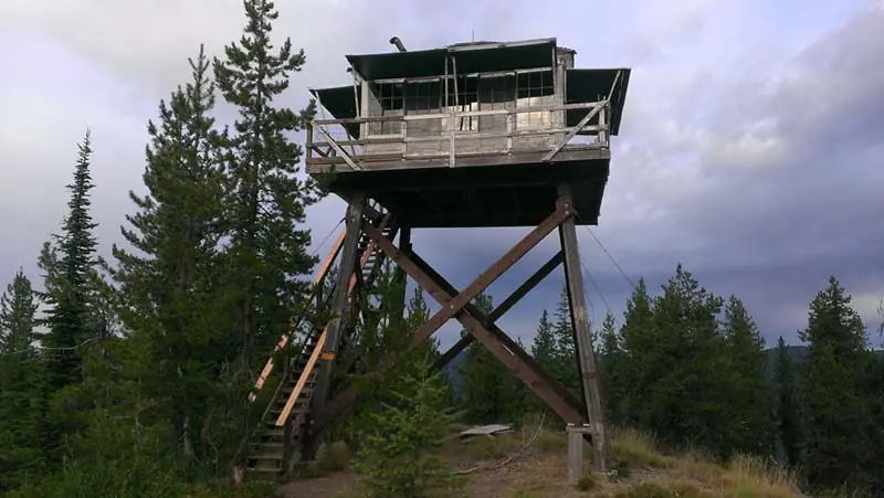
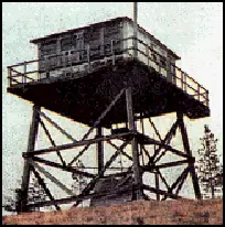
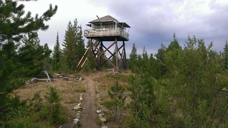
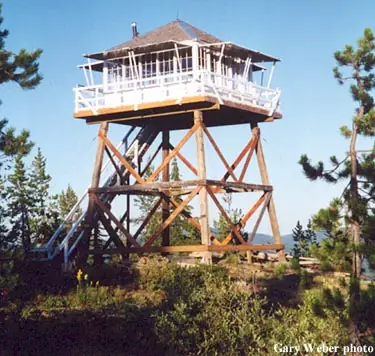
- Cab on a tower20-foot L-4 hip-roof cab with catwalk on timber towerThe design: L-4
- Built of
- Not recorded
- Built
- 1934
- Height
- 20 ft (6.1 m)
- Elevation
- 5,241 ft (1,598 m)
- Agency
- U.S. Forest Service
- Land
- Federal land
- Location
- Shoshone County, Idaho
- Coordinates
- 47.35896, −115.76382
- Registers
- This entry
- VerifiedResearched, then checked independently. Updated 19 Oct 2026.
- Firefinder id
us-id-arid-peak
View from the cab
What you see from the cab: every ridge out to about 93 miles, the named peaks in sight, and other fire lookouts within view, worked out from terrain data in your browser.
Downloads about 4.1 MB of terrain data the first time.
Or see what it could see on the map: the ground in its line of sight.
History
Then and now
- 1934 BuiltBuilt to watch for fires sparked by Milwaukee Road trains on the Loop Creek/St. Joe line; NHLR instead gives 1931Sources: recreation.gov, idahofirelookouts.com, nhlr.org
- No record between 1934 and 1967
- 1967 StaffedKnown staff record: Thomas Langseth, per Kellogg Evening NewsSource: idahofirelookouts.com
- 1969 AlteredTower legs replacedSources: nhlr.org, idahofirelookouts.com
- 1969 Last staffedLast staffed season; Recreation.gov also states the lookout was last staffed in 1969Sources: recreation.gov, idahofirelookouts.com
- 1970 EventTower stairs collapsedSource: idahofirelookouts.com
- No record between 1970 and 1995
- 1995 Added to the National Historic Lookout RegisterDate registered per NHLR detail page: October 2, 1995Source: NHLR register entry
- 1997 RestoredRestoration by Idaho FFLA chapter, St. Joe Ranger District and 30+ volunteers completedSources: recreation.gov, idahofirelookouts.com
- 2008 Condition assessmentWinter damage to the lookout was assessed.Source: firelookout.org
- 2008 RestoredChapter stabilized the lookout and cleaned up the winter damage.Source: firelookout.org
- TodayStandingIt still stands, as far as our sources know.
Old maps of this spot
USGS topographic maps from the years a lookout stood may show it, often as a small symbol labelled “Lookout”. See the old topo maps around it on the Firefinder map, or find every scanned sheet of this spot on USGS TopoView (opens another site) (click the spot there to list them, with dates and downloads).
Story
Researched 4 Oct 2026, fact-checked.
Arid Peak Lookout was built in 1934 to watch for a very specific hazard: fires sparked by Milwaukee Road trains on the grade that descends from the Montana state line, by way of Loop Creek, to the North Fork of the St. Joe River near Avery.1,2 (The National Historic Lookout Register gives the build year as 1931 instead; most other sources agree on 1934, which this story follows.3) The result was a 20-foot L-4 hip-roof cab on a timber tower with a catwalk, set in a roadless stretch of what's now the Idaho Panhandle National Forest.3,2
The tower's legs were replaced in 1969, but that turned out to be its last working year — the lookout went unstaffed after that, and by 1970 its stairs had collapsed.3,2 It sat idle for roughly 25 years.3
In 1996 and 1997, the Idaho Chapter of the Forest Fire Lookout Association teamed up with the St. Joe Ranger District and more than 30 volunteers to bring it back. They replaced the beams under the cab and atop the legs and rebuilt the stairs, finishing the restoration in 1997.1,2 The lookout was added to the National Historic Lookout Register, and it was known to have been staffed at least as late as 1967 by Thomas Langseth, per local newspaper records.3,2
Today Arid Peak is part of the Forest Service's recreation rental program. Getting there takes a roughly three-mile hike up a fairly steep grade, and the cabin sleeps up to four guests with cots, a wood stove, a propane camp stove and lantern, and an outhouse outside — guests pack in their own water and pack out everything else.1 From the catwalk the views run 360 degrees across the Bitterroot Mountains, and the lookout overlooks the Route of the Hiawatha rail-trail, built along the old Milwaukee line it once watched over.1,2
- Arid Peak Lookout, Idaho Panhandle National Forests, Recreation.gov, https://www.recreation.gov/camping/campgrounds/234447 (accessed 2026-10-04). ↩
- Arid Peak Lookout, Idaho Fire Lookouts, https://www.idahofirelookouts.com/st-joe-clearwater-region/arid-peak-lookout-2/ (accessed 2026-10-04). ↩
- Arid Peak Lookout, National Historic Lookout Register, http://nhlr.org/lookouts/us/id/arid-peak-lookout/ (accessed 2026-10-04). ↩
Photos
Photos keep their own rights and are shown with credit. Is one of these yours? You can ask for a different credit or for removal.
Sources
- National Historic Lookout Register (NHLR) (opens another site) Gave us: name, location, county, elevation, register numbers, agency, dates, photos, links National Historic Lookout Register (nhlr.org) · All rights reserved (American Resources, Inc.); facts extracted only, no prose copied. · retrieved 4 Oct 2026
- Forest Fire Lookout Association (FFLA) - US lookout lists (opens another site) Gave us: type, status, register numbers, links Forest Fire Lookout Association (firelookout.org) · No licence stated; facts extracted only, no prose copied. · retrieved 8 Oct 2026
- Recreation Information Database (recreation.gov) (opens another site) Gave us: ownership, access, rental details, links Data source: ridb.recreation.gov · Public data from the US government · retrieved 19 Oct 2026
- Forest Fire Lookout Association: lookout rentals (opens another site) Gave us: rental details, links Forest Fire Lookout Association rentals list (firelookout.org) · No licence stated; facts extracted only (state, name, booking link, manager, closure note), no prose copied. The FFLA says it is not involved in managing any rental program. · retrieved 19 Oct 2026
- firelookout.com -- Rex Kamstra's Forest Fire Lookout Page (opens another site) Gave us: design, dates, photos, links firelookout.com · No licence stated on the site; facts only (coordinates, elevation, built/destroyed years, design, agency). Photos mirrored with the site's stated credit. · retrieved 4 Oct 2026
- Idaho Fire Lookouts (idahofirelookouts.com) (opens another site) Gave us: photos, links idahofirelookouts.com · No licence stated; facts only (coordinates, status/built/destroyed year parsed from each entry's short excerpt). Thumbnail photos mirrored with credit per the project's photo policy. · retrieved 4 Oct 2026
- Forest Fire Lookout Association chapter reports (opens another site) Gave us: dates, links Forest Fire Lookout Association, chapter and restoration-grant reports (firelookout.org) · No licence stated; facts only (dates, names, the kind of work done). Every note is our own wording and every event links to the FFLA report it comes from. Positions are copied from the NHLR, FFLOS and FFLA records. · retrieved 8 Oct 2026
- FOREST LOOKOUTS -- western US (Ron Kemnow's weebly sites) (opens another site) Gave us: height, links Ron Kemnow's Forest Lookouts sites (westlookouts, californialookouts, idaholookouts, montanalookouts, oregonlookouts and washingtonlookouts .weebly.com) · No licence stated; facts only (county, land manager, status word, coordinates where the page's own map widget gives them, township-range-section, height and design hints, links). The site's own newspaper quotes, citations and narrative are not reproduced. · retrieved 8 Oct 2026
- Firefinder research Gave us: summary, design, status, agency, access, staffing, visiting details, dates, links, fact-check Firefinder research (sources cited in the story footnotes) · Our own research notes; each fact cites its source in the lookout's story
More about this lookout elsewhere
- NHLR register entry US 153 (nhlr.org) (opens another site)
- Recreation.gov listing (opens another site)
- FFLA Idaho lookout list (firelookout.org) (opens another site)
- FFLA lookout rentals list (firelookout.org) (opens another site)
- Forest Fire Lookout Association chapter reports: work on Arid Peak Lookout (opens another site)
- Arid Peak on firelookout.com (Rex Kamstra) (opens another site)
- Arid Peak Lookout on idahofirelookouts.com (opens another site)
- Arid Peak on Forest Lookouts, western US (Ron Kemnow) (opens another site)
Firefinder takes facts (places, dates, numbers) from these sources and writes its own words. See all sources and licences.