Fire lookout · Bonner County, Idaho
Cuban Hill
Bonner County, ID lookout: 1922 cabin, 1935 30-foot L-4 tower, destroyed 1964; footings reported on the summit, no tower left standing.
- Gone
- Access unknown
- Verified
Gone: The lookout no longer stands. Only the site is left. Destroyed in 1964; site photo captions mention footings on the summit
Visit & stay
Gone: site only. The lookout no longer stands, so there is nothing to climb or rent.
Access
Access unknown
We do not know the access rules. Check with the land manager before you go. WillhiteWeb gives driving directions and a walk to the site and notes no closure; no source states the legal access status
- Road to the top?
- Yes, you can drive up
- Trail
- Drive up State Highway 57 and Stone Johnny Road to an old parking spot, then walk the overgrown last half mile. No tower remains to climb.
Facts
- Status
- Type
- Cab on a tower30-foot pole tower with an L-4 cab, replacing a 1922 frame cabinThe design: L-4
- Built of
- Not recorded
- Built
- 1922
- Height
- 30 ft (9.1 m)
- Elevation
- Unknown
- Agency
- Kaniksu National Forest
- Land
- Federal land
- Location
- Bonner County, Idaho
- Coordinates
- 48.24722, −116.92243
- Registers
- Not on a lookout register
- This entry
- VerifiedResearched, then checked independently. Updated 10 Oct 2026.
- Firefinder id
us-id-cuban-hill
View from the cab
What the lookout saw from its cab: every ridge out to about 93 miles, the named peaks in sight, and other fire lookouts within view, worked out from terrain data in your browser.
This lookout is gone. The view is reconstructed from its recorded site and its recorded height.
Downloads about 4.1 MB of terrain data the first time.
Or see what it could see on the map: the ground in its line of sight.
History
Then and now
- 1922 Built12-by-12-foot frame cabin; communication wires run to the siteSources: idaholookouts.weebly.com, willhiteweb.com
- 1925 AlteredCupola roof put on the cabin in place of the gable roof, per Peterson; two other sources date the cupola to 1925Sources: npshistory.com, idaholookouts.weebly.com, willhiteweb.com
- 1925 StaffedHenry A. Peterson posted as lookout for the 1925 season; Tom Terrell sent up as smokechaser to help with the roofSource: npshistory.com
- 1935 Replaced by a new structure30-foot pole tower with L-4 cab replaces the cabinSources: firelookout.com, idaholookouts.weebly.com, willhiteweb.com
- No record between 1935 and 1964
- 1964 DestroyedTower destroyed; four sources agree on the yearSources: firelookout.com, idaholookouts.weebly.com, willhiteweb.com
- 1967 EventUSGS benchmark placed at the highest point, using the old footings as reference marksSource: willhiteweb.com
- TodayGoneThe lookout no longer stands. Only the site is left.
Old maps of this spot
USGS topographic maps from the years a lookout stood may show it, often as a small symbol labelled “Lookout”. See the old topo maps around it on the Firefinder map, or find every scanned sheet of this spot on USGS TopoView (opens another site) (click the spot there to list them, with dates and downloads).
Story
Researched 10 Oct 2026, fact-checked.
Cuban Hill lies four to five miles north of Priest River in Bonner County, Idaho, depending on which source you read.1,2 The Kaniksu National Forest is listed as the agency that ran its lookout.1 A newspaper report from June 1922 said wires were being laid to station a government lookout on the hill.2 That same year a 12-by-12-foot frame cabin went up, and communication wires were run to the site.2,3
Henry A. Peterson was a Forest Service lookout here in 1925, and he wrote that the cabin then had a gable roof. His job that summer included taking that roof off and putting a cupola roof on.4 Two sources date the cupola to 1925.2,3 Two others describe a cupola cabin from 1922.1,5
Peterson was hired at the Falls Ranger Station and spent the 1925 season on the hill.4 He recalled that a smokechaser named Tom Terrell was sent up that summer to help with the roofing. He also wrote that a series of fires burned over the upper part of the Westbranch drainage that year while he was posted there.4
The cabin gave way in 1935 to a 30-foot pole tower with an L-4 cab.1,2,3 The tower was destroyed in 1964, and four of the sources we read agree on that date.1,2,3,5
In 1967 a USGS team set a benchmark at the highest point and used the old footings as reference marks.3 Captions on WillhiteWeb's site photos refer to footings on the summit.3 None of the sources we read describes any other structure standing there now.
The drive from Priest River runs up State Highway 57 to Stone Johnny Road and then along gravel to an old parking spot.3 The last half mile is growing over, so walking it is now easier than driving it.3 Nothing of the tower is left to climb.1,5 No source we read says whether the site is open to the public, so ask the Kaniksu National Forest before you go.
- Cuban Hill Fire Lookout Tower, firelookout.com, https://www.firelookout.com/id/cubanhill.html (accessed 2026-10-10). ↩
- Cuban Hill - FOREST LOOKOUTS, Forest Lookouts (Idaho), https://idaholookouts.weebly.com/cuban-hill.html (accessed 2026-10-10). ↩
- Cuban Hill Lookout Site, WillhiteWeb.com, https://willhiteweb.com/idaho_lookouts/cuban_hill/lookout_site_018.htm (accessed 2026-10-10). ↩
- Early Days in the Forest Service, Volume 4: Early-Day Ranger in the Priest Lake Country, Henry A. Peterson, npshistory.com, https://npshistory.com/publications/usfs/region/1/early-days/4/sec39.htm (accessed 2026-10-10). ↩
- Cuban Hill - Idaho Fire Lookouts, Idaho Fire Lookouts, https://www.idahofirelookouts.com/northern-idaho/cuban-hill/ (accessed 2026-10-10). ↩
Photos
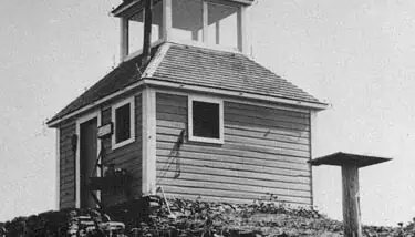
Photos keep their own rights and are shown with credit. Is one of these yours? You can ask for a different credit or for removal.
Sources
- Forest Fire Lookout Association (FFLA) - US lookout lists (opens another site) Gave us: name, location, county, type, status, links Forest Fire Lookout Association (firelookout.org) · No licence stated; facts extracted only, no prose copied. · retrieved 8 Oct 2026
- firelookout.com -- Rex Kamstra's Forest Fire Lookout Page (opens another site) Gave us: links firelookout.com · No licence stated on the site; facts only (coordinates, elevation, built/destroyed years, design, agency). Photos mirrored with the site's stated credit. · retrieved 4 Oct 2026
- Idaho Fire Lookouts (idahofirelookouts.com) (opens another site) Gave us: dates, photos, links idahofirelookouts.com · No licence stated; facts only (coordinates, status/built/destroyed year parsed from each entry's short excerpt). Thumbnail photos mirrored with credit per the project's photo policy. · retrieved 4 Oct 2026
- FOREST LOOKOUTS -- western US (Ron Kemnow's weebly sites) (opens another site) Gave us: design, height, agency, ownership, links Ron Kemnow's Forest Lookouts sites (westlookouts, californialookouts, idaholookouts, montanalookouts, oregonlookouts and washingtonlookouts .weebly.com) · No licence stated; facts only (county, land manager, status word, coordinates where the page's own map widget gives them, township-range-section, height and design hints, links). The site's own newspaper quotes, citations and narrative are not reproduced. · retrieved 8 Oct 2026
- Firefinder research Gave us: summary, design, status, agency, access, staffing, visiting details, dates, links, fact-check Firefinder research (sources cited in the story footnotes) · Our own research notes; each fact cites its source in the lookout's story
More about this lookout elsewhere
- Cuban Hill Lookout Site (WillhiteWeb.com) (opens another site)
- Early Days in the Forest Service, Volume 4: Early-Day Ranger in the Priest Lake Country (Henry A. Peterson) (npshistory.com) (opens another site)
- FFLA Idaho lookout list (firelookout.org) (opens another site)
- Cuban Hill on firelookout.com (Rex Kamstra) (opens another site)
- Cuban Hill on idahofirelookouts.com (opens another site)
- Cuban Hill on Forest Lookouts, western US (Ron Kemnow) (opens another site)
Firefinder takes facts (places, dates, numbers) from these sources and writes its own words. See all sources and licences.