Fire lookout · Boise County, Idaho
Dry Buck Lookout
Also known as Dry Buck Mountain
Boise NF L-4 ground cabin built 1933 on Dry Buck Mountain; destroyed by 1973; a climbing guide says its foundation still sits on the summit.
- Gone
- Open to the public
- Verified
Gone: The lookout no longer stands. Only the site is left. Cabin destroyed in 1973; a climbing guide says the lookout's foundation still sits on the summit
Visit & stay
Gone: site only. The lookout no longer stands, so there is nothing to climb or rent. You may still be able to visit the site.
Access
Open to the public. On Boise National Forest land; the climbing guide describes road access up Forest Road 643 from Banks and mentions no closure
- Road to the top?
- Yes, you can drive up
- Trail
- Per the climbing guide, the road reaches Dry Buck Summit after 11 miles; a 1.1-mile climb gaining 567 feet leads to the top. The guide does not describe current conditions.
Facts
- Status
- Type
- Ground-level cabL-4 ground cabinThe design: L-4
- Built of
- WoodGoing by its design; no source says so in words.
- Built
- 1933
- Height
- Unknown
- Elevation
- Unknown
- Agency
- Boise National Forest
- Land
- Federal land
- Location
- Boise County, Idaho
- Coordinates
- 44.14623, −116.14830 sources disagree
- Registers
- Not on a lookout register
- This entry
- VerifiedResearched, then checked independently. Updated 10 Oct 2026.
- Firefinder id
us-id-dry-buck
View from the cab
What the lookout saw from its cab: every ridge out to about 93 miles, the named peaks in sight, and other fire lookouts within view, worked out from terrain data in your browser.
This lookout is gone. The view is reconstructed from its recorded site and a typical height for a lookout like it.
Downloads about 3.8 MB of terrain data the first time.
Or see what it could see on the map: the ground in its line of sight.
History
Then and now
- 1933 BuiltL-4 ground cabin constructed in 1933 (Forest Lookouts, firelookout.com, Idaho Fire Lookouts); the climbing guide says a lookout capped the summit from 1933Sources: idaholookouts.weebly.com, firelookout.com, idahofirelookouts.com
- 1945 StaffedMiss Marylin Carlick of Ola stationed at Dry Buck, per a January 28, 1945 Idaho Statesman item quoted on Forest LookoutsSource: idaholookouts.weebly.com
- No record between 1945 and 1973
- 1973 DestroyedForest Lookouts says destroyed in 1973; firelookout.com says gone by 1973; Idaho Fire Lookouts gives 1973 as goneSources: idaholookouts.weebly.com, firelookout.com, idahofirelookouts.com
- TodayGoneThe lookout no longer stands. Only the site is left.
Old maps of this spot
USGS topographic maps from the years a lookout stood may show it, often as a small symbol labelled “Lookout”. See the old topo maps around it on the Firefinder map, or find every scanned sheet of this spot on USGS TopoView (opens another site) (click the spot there to list them, with dates and downloads).
Story
Researched 10 Oct 2026, fact-checked.
Dry Buck Lookout was an L-4 cab built in 1933 on Dry Buck Mountain, about four miles north-northwest of Banks in Boise County, Idaho.1,2 The lookout stood at about 6,508 feet, in the Boise National Forest.2,3
A January 28, 1945 Idaho Statesman item, quoted by Forest Lookouts, names Miss Marylin Carlick of Ola as stationed at Dry Buck in the High Valley district.1 Idaho Fire Lookouts, by contrast, has not yet documented any staffing history for the lookout.3
Forest Lookouts says the lookout was destroyed in 1973.1 Firelookout.com says it was gone by then.2 The Forest Fire Lookout Association lists it as a ground site that is gone.4 According to a climbing guide, a lookout stood on the summit between 1933 and the early 1970s.5
The same guide reports that the foundation remains on the summit, and that the mountain's true high point is a granite outcrop just west of the foundation.5 None of the sources we read describes the foundation in more detail, or what else, if anything, is left.1,2,3,5,4
The site is on Boise National Forest land.2 The climbing guide describes a route from Idaho 55 at Banks up Forest Road 643.5 Eleven miles up the road, you reach Dry Buck Summit, a high saddle; from there a 1.1-mile climb gaining 567 feet leads to the top.5 The guide does not mention a closure.5 Road conditions change, though, so check with the Boise National Forest before you go.
- Dry Buck Mountain, Forest Lookouts, https://idaholookouts.weebly.com/dry-buck-mountain.html (accessed 2026-10-10). ↩
- Dry Buck Fire Lookout Cabin, firelookout.com, https://www.firelookout.com/id/drybuck.html (accessed 2026-10-10). ↩
- Dry Buck Lookout, Idaho Fire Lookouts, https://www.idahofirelookouts.com/southern-idaho/dry-buck-lookout/ (accessed 2026-10-10). ↩
- Idaho Lookouts, Forest Fire Lookout Association, https://firelookout.org/lookouts/us/id (accessed 2026-10-10). ↩
- Dry Buck Mountain, IDAHO: A Climbing Guide, https://www.idahoaclimbingguide.com/bookupdates/dry-buck-mountain/ (accessed 2026-10-10). ↩
Photos
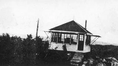
Photos keep their own rights and are shown with credit. Is one of these yours? You can ask for a different credit or for removal.
Where sources disagree
We show disagreements between sources instead of quietly picking one. If you know which is right, please tell us.
Sources disagree on the location by 2.2 km (1.3 mi).
- FFLA: 44.14623, −116.14830
- FOREST LOOKOUTS -- western US (Ron Kemnow's weebly sites): 44.12711, −116.15346
The map uses the position from FFLA.
Sources
- Forest Fire Lookout Association (FFLA) - US lookout lists (opens another site) Gave us: name, location, county, type, status, links Forest Fire Lookout Association (firelookout.org) · No licence stated; facts extracted only, no prose copied. · retrieved 8 Oct 2026
- firelookout.com -- Rex Kamstra's Forest Fire Lookout Page (opens another site) Gave us: links firelookout.com · No licence stated on the site; facts only (coordinates, elevation, built/destroyed years, design, agency). Photos mirrored with the site's stated credit. · retrieved 4 Oct 2026
- Idaho Fire Lookouts (idahofirelookouts.com) (opens another site) Gave us: photos, links idahofirelookouts.com · No licence stated; facts only (coordinates, status/built/destroyed year parsed from each entry's short excerpt). Thumbnail photos mirrored with credit per the project's photo policy. · retrieved 4 Oct 2026
- FOREST LOOKOUTS -- western US (Ron Kemnow's weebly sites) (opens another site) Gave us: what it is built of, design, agency, ownership, links Ron Kemnow's Forest Lookouts sites (westlookouts, californialookouts, idaholookouts, montanalookouts, oregonlookouts and washingtonlookouts .weebly.com) · No licence stated; facts only (county, land manager, status word, coordinates where the page's own map widget gives them, township-range-section, height and design hints, links). The site's own newspaper quotes, citations and narrative are not reproduced. · retrieved 8 Oct 2026
- Firefinder research Gave us: summary, design, status, agency, access, visiting details, dates, links, fact-check Firefinder research (sources cited in the story footnotes) · Our own research notes; each fact cites its source in the lookout's story
More about this lookout elsewhere
- Dry Buck Mountain (IDAHO: A Climbing Guide) (opens another site)
- FFLA Idaho lookout list (firelookout.org) (opens another site)
- Dry Buck on firelookout.com (Rex Kamstra) (opens another site)
- Dry Buck Lookout on idahofirelookouts.com (opens another site)
- Dry Buck Mountain on Forest Lookouts, western US (Ron Kemnow) (opens another site)
Firefinder takes facts (places, dates, numbers) from these sources and writes its own words. See all sources and licences.