Fire lookout · Shoshone County, Idaho
Lick Point Lookout
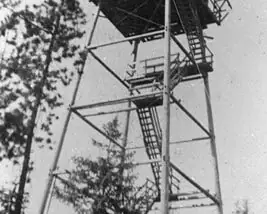
50-foot pole L-4 tower on St. Joe National Forest, built in 1934 and destroyed in 1951; drive-up, and no source describes the site today.
- Gone
- Open to the public
- Verified
Gone: The lookout no longer stands. Only the site is left. Destroyed in 1951
Visit & stay
Gone: site only. The lookout no longer stands, so there is nothing to climb or rent. You may still be able to visit the site.
Access
Open to the public. Drive-up site on St. Joe National Forest land; no source describes a closure
- Road to the top?
- Yes, you can drive up
Facts
- Status
- Type
- Cab on a tower50-foot pole tower with L-4 cabThe design: L-4
- Built of
- Not recorded
- Built
- 1934
- Height
- 50 ft (15.2 m)
- Elevation
- Unknown
- Agency
- US Forest Service - St. Joe National Forest
- Land
- Unknown
- Location
- Shoshone County, Idaho
- Coordinates
- 47.16616, −115.85974
- Registers
- Not on a lookout register
- This entry
- VerifiedResearched, then checked independently. Updated 10 Oct 2026.
- Firefinder id
us-id-lick-point
View from the cab
What the lookout saw from its cab: every ridge out to about 93 miles, the named peaks in sight, and other fire lookouts within view, worked out from terrain data in your browser.
This lookout is gone. The view is reconstructed from its recorded site and its recorded height.
Downloads about 3.9 MB of terrain data the first time.
Or see what it could see on the map: the ground in its line of sight.
History
Then and now
- 1934 Built50-foot pole tower with an L-4 cabSources: firelookout.com, idahofirelookouts.com
- No record between 1934 and 1951
- 1951 DestroyedBoth sites give 1951 as the year the tower was destroyedSources: firelookout.com, idahofirelookouts.com
- TodayGoneThe lookout no longer stands. Only the site is left.
Old maps of this spot
USGS topographic maps from the years a lookout stood may show it, often as a small symbol labelled “Lookout”. See the old topo maps around it on the Firefinder map, or find every scanned sheet of this spot on USGS TopoView (opens another site) (click the spot there to list them, with dates and downloads).
Story
Researched 10 Oct 2026, fact-checked.
Lick Point Lookout stood in the St. Joe National Forest, about six miles south-southwest of Avery in Shoshone County, at an elevation of 4,200 feet.1,2
The tower was a 50-foot pole structure with an L-4 cab. It went up in 1934.1,2
Both websites record the tower as destroyed in 1951.1,2 They agree on the dates and the elevation, and both credit the tower photograph on their pages to the Fire Lookout Museum.1,2 The Forest Fire Lookout Association's Idaho list also files the site as a tower that is gone, which matches both websites.3,1,2
No source describes what, if anything, remains at the site today. Idaho Fire Lookouts lists the site as drive-up, which means it can be reached by road, and no source describes a closure.2
- Lick Point Fire Lookout Tower, firelookout.com, https://www.firelookout.com/id/lickpoint.html (accessed 2026-10-10). ↩
- Lick Point Lookout – Idaho Fire Lookouts, Idaho Fire Lookouts, https://www.idahofirelookouts.com/st-joe-clearwater-region/lick-point-lookout/ (accessed 2026-10-10). ↩
- Idaho Lookouts (Alphabetical List), Forest Fire Lookout Association, https://firelookout.org/lookouts/us/id (accessed 2026-10-10). ↩
Photos
Photos keep their own rights and are shown with credit. Is one of these yours? You can ask for a different credit or for removal.
Sources
- Forest Fire Lookout Association (FFLA) - US lookout lists (opens another site) Gave us: name, location, county, type, status, links Forest Fire Lookout Association (firelookout.org) · No licence stated; facts extracted only, no prose copied. · retrieved 8 Oct 2026
- firelookout.com -- Rex Kamstra's Forest Fire Lookout Page (opens another site) Gave us: links firelookout.com · No licence stated on the site; facts only (coordinates, elevation, built/destroyed years, design, agency). Photos mirrored with the site's stated credit. · retrieved 4 Oct 2026
- Idaho Fire Lookouts (idahofirelookouts.com) (opens another site) Gave us: dates, photos, links idahofirelookouts.com · No licence stated; facts only (coordinates, status/built/destroyed year parsed from each entry's short excerpt). Thumbnail photos mirrored with credit per the project's photo policy. · retrieved 4 Oct 2026
- Firefinder research Gave us: summary, design, height, status, agency, access, visiting details, dates, links, fact-check Firefinder research (sources cited in the story footnotes) · Our own research notes; each fact cites its source in the lookout's story
More about this lookout elsewhere
- FFLA Idaho lookout list (firelookout.org) (opens another site)
- Lick Point on firelookout.com (Rex Kamstra) (opens another site)
- Lick Point Lookout on idahofirelookouts.com (opens another site)
Firefinder takes facts (places, dates, numbers) from these sources and writes its own words. See all sources and licences.