Fire lookout · Bonner County, Idaho
Lunch Peak Lookout
The last standing lookout on the Sandpoint Ranger District, Lunch Peak's 1971 cab was wrapped to survive the 2021 Trestle Creek fire and is now a rental.
- Standing
- Rentable
- Open to the public
- Verified
Visit & stay
You can rent this lookout for overnight stays through recreation.gov.
- Getting there
- Recreation The Pend Oreille Divide Trail #67 starts just below the lookout and is suitable for hiking, horseback riding and mountain biking.
Overview Lunch Peak lookout offers breathtaking views of Cabinet Mountain Wilderness, the Selkirk Mountains and Lake Pend Oreille. Located in the Cabinet Mountains, 35 miles northeast of Sandpoint, Idaho, the lookout sits at 6,414 ft. Guests can enjoy easy access to Pend Oreille Divide Trail #67. The lookout is remote and rustic with no heat, furnishings, water or cooking facilities. This basic structure lets visitors experience the feeling of "roughing it" while enjoying the cozy shelter and incredible views of the mountains and valleys below. Recreation The Pend Oreille Divide Trail #67 starts just below the lookout and is suitable for hiking, horseback riding and mountain biking. It follows ridge lines for much of its length and offers great views in all directions. A nice day hike is out to Mt. Pend Oreille and back. 8 miles roundtrip. Facilities The 15'x15' cabin was remodeled in 2002 and sits atop a 15' high cinder block foundation. No water or heat is provided. The lookout has limited furnishings which include a sleeping platform, table and cabinet. A modern vault toilet is located at the Pend Oreille Divide trailhead, 300 feet away. The last four miles of the access road is rough in spots and high clearance vehicles are necessary. Natural Features The lookout is located northeast of Sandpoint, Idaho and Lake Pend Oreille at an elevation of 6,414 feet. Bear, deer, elk, and cougar are among the wildlife native to the area. Visitors are cautioned to be aware of and practice bear safety while staying at Lunch Peak Lookout. Nearby Attractions The closest convenience store and fuel is located in Hope, Idaho, approximately 20 miles or a one hour drive. Charges & Cancellations CLOSED 2021
Book on recreation.gov (opens recreation.gov)
Rental details from recreation.gov, checked 19 Oct 2026. Rules, fees and seasons change, so confirm on the booking page before you go. Data source: ridb.recreation.gov
Access
Open to the public. Forest Service recreation rental (recreation.gov); last 4 miles of access road rough, high-clearance recommended.
- Can you climb it?
- No
- Road to the top?
- No, you have to hike
- Trail
- Pend Oreille Divide Trail #67 starts just below the lookout; rental cabin.
- Staffing
- Unknown
Facts
- Status
- Built of
- WoodGoing by its design; no source says so in words.
- Built
- 1937 sources disagree
- Height
- 10 ft (3.0 m)
- Elevation
- 6,258 ft (1,907 m)
- Agency
- U.S. Forest Service
- Land
- Federal land
- Location
- Bonner County, Idaho
- Coordinates
- 48.37500, −116.19417 sources disagree
- Registers
- This entry
- VerifiedResearched, then checked independently. Updated 19 Oct 2026.
- Firefinder id
us-id-lunch-peak
View from the cab
What you see from the cab: every ridge out to about 93 miles, the named peaks in sight, and other fire lookouts within view, worked out from terrain data in your browser.
Downloads about 4.2 MB of terrain data the first time.
Or see what it could see on the map: the ground in its line of sight.
History
Then and now
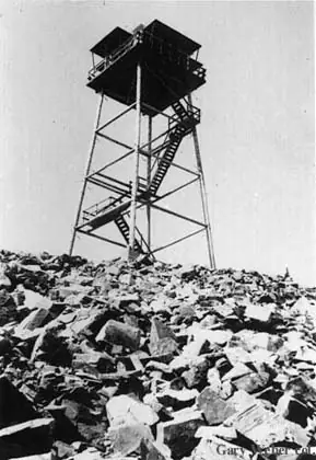
- 1937 BuiltFirst lookout: 45-foot pole tower with L-4 cab.Sources: nhlr.org, firelookout.com
- No record between 1937 and 1971
- 1971 Built'Built' field on NHLR detail pageSource: NHLR register entry
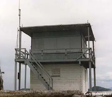
- 1971 Replaced by a new structureCurrent 15x15-ft flattop/R-6 cab on 10-ft concrete base built.Sources: nhlr.org, firelookout.com
- 1985 Last staffedLast staffed full-time.Source: firelookout.com
- No record between 1985 and 2002
- 2002 AlteredCabin remodeled.Source: recreation.gov
- 2004 Added to the National Historic Lookout RegisterDate registered per NHLR detail page: February 12, 2004Source: NHLR register entry
- No record between 2004 and 2021
- 2021 FireTrestle Creek Complex fire nearby; crew wrapped the lookout in protective material due to local concern it could be lost.Source: idahofirelookouts.com
- TodayStandingIt still stands, as far as our sources know.
Old maps of this spot
USGS topographic maps from the years a lookout stood may show it, often as a small symbol labelled “Lookout”. See the old topo maps around it on the Firefinder map, or find every scanned sheet of this spot on USGS TopoView (opens another site) (click the spot there to list them, with dates and downloads).
Story
Researched 4 Oct 2026, fact-checked.
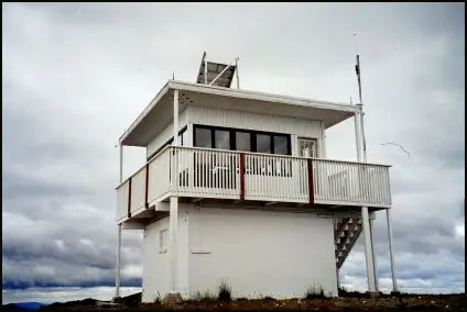
Lunch Peak Lookout stands in the Cabinet Mountains about 35 miles northeast of Sandpoint, Idaho, overlooking Lake Pend Oreille and the Selkirk Mountains.1 Fire detection began here in 1937, when the Forest Service put up a pole tower topped with an L-4 cab; the National Historic Lookout Register gives the pole's height as 50 feet, while firelookout.com gives 45 feet.2,3 That structure was replaced in 1971 with the building that stands today: a 15-by-15-foot flat-roofed cab with a catwalk, set on a 10-foot concrete block base.3,2 Sources differ on the exact design label for the current cab, with the National Historic Lookout Register calling it a flattop cab and firelookout.com describing it as an R-6 flat cab, but they agree on the 1971 construction date.3,2
The lookout was staffed through the mid-twentieth century; researchers have documented personnel including Harold Harding in 1967 and Diane Young from 1975 to 1978.4,3 Full-time staffing ended in 1985, after which Lunch Peak became the last of the Sandpoint Ranger District's lookouts still standing from that era.2,3
The tower's most dramatic recent moment came during the 2021 fire season, when the Trestle Creek Complex fire burned nearby and a Forest Service crew wrapped the structure in protective fire-resistant material out of concern from local residents that the historic cabin could be lost.4 The lookout survived.
Today Lunch Peak is no longer used for fire detection but is maintained and offered through the Forest Service's recreation rental program.1,2 The cabin was remodeled in 2002 and remains rustic, with a sleeping platform, table, and cabinet but no water, heat, or cooking facilities.1 It sits atop a 15-foot cinder block foundation, reached by the last four miles of a rough, high-clearance access road, with the Pend Oreille Divide Trail starting just below.1 Access is public via recreation.gov booking.
- Lunch Peak Lookout, Recreation.gov, https://www.recreation.gov/camping/campgrounds/234430 (accessed 2026-10-04). ↩
- Lunch Peak Lookout, National Historic Lookout Register, http://nhlr.org/lookouts/us/id/lunch-peak-lookout/ (accessed 2026-10-04). ↩
- Lunch Peak Fire Lookout Tower, Fire Lookout (firelookout.com), https://www.firelookout.com/id/lunchpk.html (accessed 2026-10-04). ↩
- Lunch Peak Lookout, Idaho Fire Lookouts, https://www.idahofirelookouts.com/northern-idaho/lunch-peak-lookout/ (accessed 2026-10-04). ↩
Photos
Photos keep their own rights and are shown with credit. Is one of these yours? You can ask for a different credit or for removal.
Where sources disagree
We show disagreements between sources instead of quietly picking one. If you know which is right, please tell us.
Sources disagree on the location by 1.0 km (0.6 mi).
- NHLR: 48.37500, −116.19417
- recreation.gov: 48.36806, −116.18500
The map uses the position from NHLR.
Sources disagree on the year it was built.
- NHLR: 1971
- firelookout.com -- Rex Kamstra's Forest Fire Lookout Page: 1937
Sources give different build years. Often one counts the first lookout on the site and another the structure there now.
Sources
- National Historic Lookout Register (NHLR) (opens another site) Gave us: name, location, county, elevation, register numbers, agency, dates, photos, links National Historic Lookout Register (nhlr.org) · All rights reserved (American Resources, Inc.); facts extracted only, no prose copied. · retrieved 4 Oct 2026
- Forest Fire Lookout Association (FFLA) - US lookout lists (opens another site) Gave us: type, status, register numbers, links Forest Fire Lookout Association (firelookout.org) · No licence stated; facts extracted only, no prose copied. · retrieved 8 Oct 2026
- Recreation Information Database (recreation.gov) (opens another site) Gave us: ownership, access, rental details, links Data source: ridb.recreation.gov · Public data from the US government · retrieved 19 Oct 2026
- Forest Fire Lookout Association: lookout rentals (opens another site) Gave us: rental details, links Forest Fire Lookout Association rentals list (firelookout.org) · No licence stated; facts extracted only (state, name, booking link, manager, closure note), no prose copied. The FFLA says it is not involved in managing any rental program. · retrieved 19 Oct 2026
- firelookout.com -- Rex Kamstra's Forest Fire Lookout Page (opens another site) Gave us: what it is built of, design, height, photos, links firelookout.com · No licence stated on the site; facts only (coordinates, elevation, built/destroyed years, design, agency). Photos mirrored with the site's stated credit. · retrieved 4 Oct 2026
- Idaho Fire Lookouts (idahofirelookouts.com) (opens another site) Gave us: photos, links idahofirelookouts.com · No licence stated; facts only (coordinates, status/built/destroyed year parsed from each entry's short excerpt). Thumbnail photos mirrored with credit per the project's photo policy. · retrieved 4 Oct 2026
- FOREST LOOKOUTS -- western US (Ron Kemnow's weebly sites) (opens another site) Gave us: links Ron Kemnow's Forest Lookouts sites (westlookouts, californialookouts, idaholookouts, montanalookouts, oregonlookouts and washingtonlookouts .weebly.com) · No licence stated; facts only (county, land manager, status word, coordinates where the page's own map widget gives them, township-range-section, height and design hints, links). The site's own newspaper quotes, citations and narrative are not reproduced. · retrieved 8 Oct 2026
- Firefinder research Gave us: summary, design, height, status, agency, access, visiting details, dates, links, fact-check Firefinder research (sources cited in the story footnotes) · Our own research notes; each fact cites its source in the lookout's story
More about this lookout elsewhere
- NHLR register entry US 541 (nhlr.org) (opens another site)
- NHLR register entry (nhlr.org) (opens another site)
- Recreation.gov listing (opens another site)
- FFLA Idaho lookout list (firelookout.org) (opens another site)
- FFLA lookout rentals list (firelookout.org) (opens another site)
- Lunch Peak on firelookout.com (Rex Kamstra) (opens another site)
- Lunch Peak Lookout on idahofirelookouts.com (opens another site)
- Lunch Peak on Forest Lookouts, western US (Ron Kemnow) (opens another site)
Firefinder takes facts (places, dates, numbers) from these sources and writes its own words. See all sources and licences.