Fire lookout · Shoshone County, Idaho
Surveyors Ridge Lookout
Also known as Surveyors Lookout
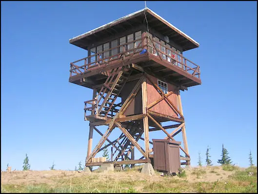
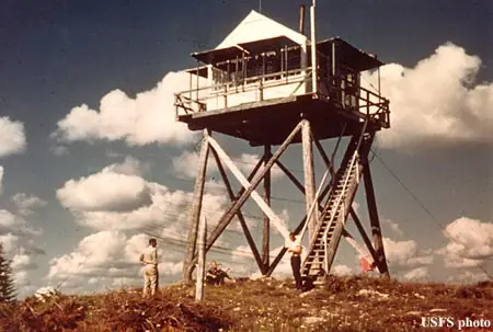
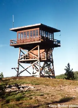
A 1931 L-4 pole lookout on St. Joe National Forest was replaced in 1964 by an R-6 flattop tower, now on emergency status and rented through the Forest Service's cabin program.
- Standing
- Rentable
- Open to the public
- Verified
Visit & stay
You can rent this lookout for overnight stays through recreation.gov.
- Sleeps
- Up to 4 people
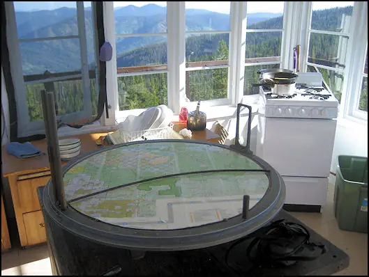
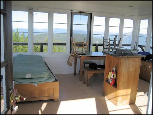
Overview Located near the Mallard-Larkins Pioneer Area Attractions, Surveyors Lookout is perched atop a 30 foot tower, providing phenomenal views of Snow Peak and the surrounding mountains. The cabin is listed on the National Historic Register for Lookouts and offers visitors a unique camping experience in the Idaho Panhandle National Forest. The original pole structure lookout was built in 1931 as part of a network of lookouts used to spot fires in the Upper St. Joe Country. The original lookout was replaced with the current treated timber structure in 1964. Access to the lookout is via a rugged single-lane road with pullouts, and is not recommended for low clearance vehicles. Road may be slick when wet. Recreation The Mallard-Larkins Pioneer Area straddles the divide between the Little North Fork Clearwater River basins and the North Fork Clearwater River. This beautiful area attracts hikers and some technical rock climbers. Hunting and trout fishing are offered in designated areas. From the lookout, there is access to Scribner Falls Trail #106 and nearby access to Surveyor's Ridge Trail #40, Horseshoe Loop Trail #141, and Northbound Creek Trail #111. A scenic drive through the upper St. Joe country is an excellent way to take in the sights leading up to the lookout. Facilities Surveyors Lookout can accommodate up to four guests. Furnishings include a propane cook stove, heater and lights. A twin bed and two extra mattresses are provided, along with a chest with some drawers. A refrigerator is also available, but it is very small and unreliable. It is recommended that guests bring a cooler with ice as backup. Cooking pots and utensils are included. No drinking water is available; guests should bring plenty of their own. An alternate option is to collect water from a spring located 1.4 miles down the access road. This water is non-potable and must be boiled or treated before consuming. Items to pack include food, bedding, a first aid kit, dish soap, towels, toiletries and binoculars. If planning to collect water from a stream, water containers are needed. Guests are advised to bring warm clothes and blankets for cold evenings. Although a heater is provided, the lookout is not insulated so it remains cold. Natural Features Surveyors Lookout is located atop Surveyors Ridge at an elevation of 6,000 feet. The 30 foot tower overlooks the spectacular Mallard-Larkins Pioneer Area, which straddles the divide between the Little North Fork Clearwater River basins and the North Fork Clearwater River. Snow Peak, Middle Sister and Mallard Peak Lookouts are still standing and can be seen from Surveyors. Nearby Attractions Avery is the nearest town for conveniences.
Book on recreation.gov (opens recreation.gov)
Rental details from recreation.gov, checked 19 Oct 2026. Rules, fees and seasons change, so confirm on the booking page before you go. Data source: ridb.recreation.gov
Access
Open to the public. Reached via a rugged single-lane road with pullouts, not recommended for low-clearance vehicles.
- Can you climb it?
- Yes
- Road to the top?
- Yes, you can drive up
- Trail
- Road can be slick when wet; not recommended for low-clearance vehicles.
- Staffing
- Unknown
Facts
- Status
- Type
- Cab on a tower15'x15' R-6 flattop cab with catwalk on a treated-timber towerThe designs: R-6, L-4
- Built of
- Wood
- Built
- 1931 sources disagree
- Height
- 20 ft (6.1 m)
- Elevation
- 4,537 ft (1,383 m)
- Agency
- U.S. Forest Service
- Land
- Federal land
- Location
- Shoshone County, Idaho
- Coordinates
- 46.99414, −115.53347 sources disagree
- Registers
- This entry
- VerifiedResearched, then checked independently. Updated 19 Oct 2026.
- Firefinder id
us-id-surveyors-ridge-2
View from the cab
What you see from the cab: every ridge out to about 93 miles, the named peaks in sight, and other fire lookouts within view, worked out from terrain data in your browser.
Downloads about 4.2 MB of terrain data the first time.
Or see what it could see on the map: the ground in its line of sight.
History
Then and now
- 1931 BuiltFirst lookout: gabled L-4 cab on a 20-ft pole tower, on the St. Joe National ForestSources: nhlr.org, firelookout.com
- No record between 1931 and 1964
- 1964 Built'Built' field on NHLR detail pageSource: NHLR register entry
- 1964 Replaced by a new structureReplaced by current R-6 15'x15' flattop cab with catwalk on a timber towerSources: nhlr.org, firelookout.com
- No record between 1964 and 1998
- 1998 Added to the National Historic Lookout RegisterRegistered July 10, 1998 as NHLR US 276Source: nhlr.org
- TodayStandingIt still stands, as far as our sources know.
Old maps of this spot
USGS topographic maps from the years a lookout stood may show it, often as a small symbol labelled “Lookout”. See the old topo maps around it on the Firefinder map, or find every scanned sheet of this spot on USGS TopoView (opens another site) (click the spot there to list them, with dates and downloads).
Story
Researched 4 Oct 2026, fact-checked.
The first lookout on Surveyors Ridge, on the St. Joe National Forest in Idaho's panhandle, went up in 1931.1,2 It was a modest structure: a gabled L-4 cab set on a 20-foot pole tower.1 That original tower was replaced in 1964 with the lookout that stands today — a 15-by-15-foot R-6 flattop cab with a catwalk, mounted on a 20-foot treated-timber tower.1,2 Sources differ slightly on the tower's exact height: the National Historic Lookout Register and firelookout.com both describe a 20-foot timber tower, while recreation.gov lists the lookout as sitting atop a 30-foot tower.1,3,2
The lookout overlooks the Mallard-Larkins Pioneer Area and remained in active fire-detection service for decades.1,2 Detail on exactly when staffing ended is thin in the available sources, but by the time firelookout.com's account was written, the tower was described as being on "emergency status," a designation Forest Service lookouts often carry once they're no longer staffed full-time but are kept ready for use during high fire danger.2 Two other patrol lookout sites once stood nearby — one about a mile and a quarter to the northeast, another two and a half miles east atop Surveyors Peak — though no detail survives here on when those were abandoned.2
The tower has since been added to the Forest Service's recreation rental program and is listed on the National Historic Lookout Register.1,2 It's reached by a narrow one-lane road dotted with pullouts; the Forest Service warns against attempting it in a low-clearance vehicle, and wet conditions can make it slippery.3 The cabin rents as a non-electric site with phenomenal views of Snow Peak and the surrounding mountains of the Idaho Panhandle National Forests.3
- Surveyors Ridge Lookout, National Historic Lookout Register (nhlr.org), http://nhlr.org/lookouts/us/id/surveyors-ridge-lookout/ (accessed 2026-10-04). ↩
- Surveyors Ridge Fire Lookout Tower, firelookout.com, https://www.firelookout.com/id/surveyorsridge.html (accessed 2026-10-04). ↩
- Surveyors Lookout, Idaho Panhandle National Forests, Recreation.gov, https://www.recreation.gov/camping/campgrounds/234395 (accessed 2026-10-04). ↩
Photos
Photos keep their own rights and are shown with credit. Is one of these yours? You can ask for a different credit or for removal.
Where sources disagree
We show disagreements between sources instead of quietly picking one. If you know which is right, please tell us.
Sources disagree on the location by 7.6 km (4.7 mi).
- NHLR: 46.99414, −115.53347
- Idaho Fire Lookouts (idahofirelookouts.com): 47.00463, −115.63210
The map uses the position from NHLR.
Sources disagree on the year it was built.
- NHLR: 1964
- firelookout.com -- Rex Kamstra's Forest Fire Lookout Page: 1964
- recreation.gov: 1931
Sources give different build years. Often one counts the first lookout on the site and another the structure there now.
Sources
- National Historic Lookout Register (NHLR) (opens another site) Gave us: name, location, county, elevation, what it is built of, register numbers, agency, dates, photos, links National Historic Lookout Register (nhlr.org) · All rights reserved (American Resources, Inc.); facts extracted only, no prose copied. · retrieved 4 Oct 2026
- Forest Fire Lookout Association (FFLA) - US lookout lists (opens another site) Gave us: type, status, register numbers, links Forest Fire Lookout Association (firelookout.org) · No licence stated; facts extracted only, no prose copied. · retrieved 8 Oct 2026
- Recreation Information Database (recreation.gov) (opens another site) Gave us: ownership, access, rental details, links Data source: ridb.recreation.gov · Public data from the US government · retrieved 19 Oct 2026
- Forest Fire Lookout Association: lookout rentals (opens another site) Gave us: rental details, links Forest Fire Lookout Association rentals list (firelookout.org) · No licence stated; facts extracted only (state, name, booking link, manager, closure note), no prose copied. The FFLA says it is not involved in managing any rental program. · retrieved 19 Oct 2026
- firelookout.com -- Rex Kamstra's Forest Fire Lookout Page (opens another site) Gave us: design, height, photos, links firelookout.com · No licence stated on the site; facts only (coordinates, elevation, built/destroyed years, design, agency). Photos mirrored with the site's stated credit. · retrieved 4 Oct 2026
- Idaho Fire Lookouts (idahofirelookouts.com) (opens another site) Gave us: photos, links idahofirelookouts.com · No licence stated; facts only (coordinates, status/built/destroyed year parsed from each entry's short excerpt). Thumbnail photos mirrored with credit per the project's photo policy. · retrieved 4 Oct 2026
- FOREST LOOKOUTS -- western US (Ron Kemnow's weebly sites) (opens another site) Gave us: links Ron Kemnow's Forest Lookouts sites (westlookouts, californialookouts, idaholookouts, montanalookouts, oregonlookouts and washingtonlookouts .weebly.com) · No licence stated; facts only (county, land manager, status word, coordinates where the page's own map widget gives them, township-range-section, height and design hints, links). The site's own newspaper quotes, citations and narrative are not reproduced. · retrieved 8 Oct 2026
- Firefinder research Gave us: summary, design, status, agency, access, visiting details, dates, links, fact-check Firefinder research (sources cited in the story footnotes) · Our own research notes; each fact cites its source in the lookout's story
More about this lookout elsewhere
- NHLR register entry US 276 (nhlr.org) (opens another site)
- Recreation.gov listing (opens another site)
- FFLA Idaho lookout list (firelookout.org) (opens another site)
- FFLA lookout rentals list (firelookout.org) (opens another site)
- Surveyors Ridge on firelookout.com (Rex Kamstra) (opens another site)
- Surveyors Ridge Lookout on idahofirelookouts.com (opens another site)
- Surveyor's Ridge on Forest Lookouts, western US (Ron Kemnow) (opens another site)
Firefinder takes facts (places, dates, numbers) from these sources and writes its own words. See all sources and licences.