Fire lookout · McCreary County, Kentucky
Stearns Fire Tower
Also known as Stearns State Lookout Tower
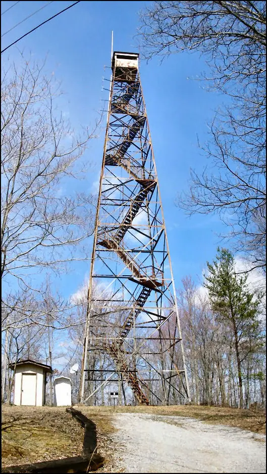
Aermotor steel lookout built by the CCC in 1934 in McCreary County, Kentucky; registers record it demolished as of 2024, with a home on the site.
- Standing
- Private land
- Verified
Private land
No public access. Please do not trespass; view it only from public land. Privately owned, per the NHLR; the registers describe no public access.
Visit & stay
Not rentable. As far as we know, this lookout cannot be booked for overnight stays.
Access
Private land. See the warning at the top of this page.
- Can you climb it?
- No
- Road to the top?
- Unknown
- Trail
- No tower remains. The site is private land at the end of Stearns Tower Road.
- Staffing
- Not staffed (as of 2016)
Facts
- Status
- sources disagree
- Type
- Cab on a tower110-foot steel Aermotor tower with a 7 x 7 ft metal cabThe design: Aermotor
- Built of
- SteelGoing by its design; no source says so in words.
- Built
- 1934
- Height
- 110 ft (33.5 m)
- Elevation
- 1,420 ft (433 m)
- Agency
- Private owner
- Land
- Federal land
- Location
- McCreary County, Kentucky
- Coordinates
- 36.70471, −84.48979
- This entry
- VerifiedResearched, then checked independently. Updated 8 Oct 2026.
- Firefinder id
us-ky-stearns
View from the cab
What you see from the cab: every ridge out to about 93 miles, the named peaks in sight, and other fire lookouts within view, worked out from terrain data in your browser.
Downloads about 3.1 MB of terrain data the first time.
Or see what it could see on the map: the ground in its line of sight.
History
Then and now
- 1934 BuiltBuilt by the Civilian Conservation Corps on Sunset Rock on the Cumberland National Forest; a 110-foot Aermotor steel tower with a 7 x 7 ft metal cabSources: nhlr.org, easternuslookouts.weebly.com, mccrearyjournal.com
- No record between 1934 and 1988
- 1988 EventRichard Burke sold the tower and six acres to Nolan and Sondra Johnson for $10,000Source: mccrearyjournal.com
- No record between 1988 and 2009
- 2009 Added to the National Historic Lookout RegisterRegistered August 3, 2009 as US 822, KY 6Source: nhlr.org
- No record between 2009 and 2024
- 2024 RemovedRegisters say demolished as of 2024; exact date not given. A home now stands on the site.Sources: nhlr.org, firetower.org
- 2026 Added to the Former Fire Lookout Sites RegisterAdded to the former lookout sites register January 2, 2026 as US 2115, KY 7Source: firetower.org
- TodayStandingIt still stands, as far as our sources know.
Old maps of this spot
USGS topographic maps from the years a lookout stood may show it, often as a small symbol labelled “Lookout”. See the old topo maps around it on the Firefinder map, or find every scanned sheet of this spot on USGS TopoView (opens another site) (click the spot there to list them, with dates and downloads).
Story
Researched 8 Oct 2026, fact-checked.
The Civilian Conservation Corps built the Stearns Fire Tower in 1934 on Sunset Rock, the highest point in McCreary County, Kentucky.1,2 The National Historic Lookout Register places it on the Cumberland National Forest, a name since changed to the Daniel Boone National Forest.3 It was a 110-foot steel Aermotor tower with a 7-by-7-foot metal cab at the top.3,1
The U.S. Forest Service first leased the land from Stearns Coal and used the tower to spot forest fires.2 By 2016 a local newspaper described the tower as no longer in use for spotting forest fires.2
Once Stearns Coal stopped operating, the tower was left unattended, and Richard Burke could buy it.2 In 1988 Burke sold the tower and six acres of land to Nolan and Sondra Johnson for $10,000.2 The Johnsons have long wanted to restore the tower and turn it into a historic tourist draw.2 In 2016 they raised framed, lit letters to the top of the tower, and people began coming to Stearns to see it.2
Both registers list the tower as torn down by 2024, and a house now sits on the site.3,4 Because the registers give only an "as of" date, the year it came down is still unclear.3,4 Today the land is privately owned, and no tower remains to climb.3,4
- Stearns - Forest Lookouts, Forest Lookouts, https://easternuslookouts.weebly.com/stearns.html (accessed 2026-10-08). ↩
- Kentucky's Trump Tower, McCreary Journal, https://www.mccrearyjournal.com/2016/09/29/kentuckys-trump-tower/ (accessed 2026-10-08). ↩
- Stearns Fire Tower, National Historic Lookout Register, http://nhlr.org/lookouts/us/ky/stearns-fire-tower/ (accessed 2026-10-08). ↩
- Stearns Tower Site, Former Fire Lookout Sites, http://firetower.org/lookouts/us/ky/stearns-tower-site/ (accessed 2026-10-08). ↩
Photos
Photos keep their own rights and are shown with credit. Is one of these yours? You can ask for a different credit or for removal.
Where sources disagree
We show disagreements between sources instead of quietly picking one. If you know which is right, please tell us.
Sources disagree on whether it still stands.
- NHLR: Standing
- FFLOS: Gone
NHLR lists lookouts that were standing when registered.
Sources
- National Historic Lookout Register (NHLR) (opens another site) Gave us: name, location, county, elevation, type, status, register numbers, agency, dates, photos, links National Historic Lookout Register (nhlr.org) · All rights reserved (American Resources, Inc.); facts extracted only, no prose copied. · retrieved 4 Oct 2026
- Former Fire Lookout Sites Register (FFLOS) (opens another site) Gave us: register numbers, dates, photos, links Former Fire Lookout Sites Register (firetower.org) · All rights reserved (American Resources, Inc.); facts extracted only, no prose copied. · retrieved 4 Oct 2026
- FOREST LOOKOUTS -- eastern US (easternuslookouts.weebly.com) (opens another site) Gave us: what it is built of, design, height, ownership, links easternuslookouts.weebly.com · No licence stated; facts only (county, coordinates where the page's own map widget gives them, status, height, design hints, register links). The site's own historical quotes, newspaper citations and narrative are not reproduced. · retrieved 8 Oct 2026
- OpenStreetMap -- fire lookout structures (opens another site) Gave us: links © OpenStreetMap contributors · ODbL 1.0. (c) OpenStreetMap contributors. · retrieved 4 Oct 2026
- Firefinder research Gave us: summary, design, height, agency, access, staffing, visiting details, dates, links, fact-check Firefinder research (sources cited in the story footnotes) · Our own research notes; each fact cites its source in the lookout's story
More about this lookout elsewhere
- NHLR register entry US 822 (nhlr.org) (opens another site)
- FFLOS register entry US 2115 (firetower.org) (opens another site)
- Kentucky's Trump Tower (McCreary Journal) (opens another site)
- Stearns (easternuslookouts.weebly.com) (opens another site)
- OpenStreetMap node 358613908 (opens another site)
Firefinder takes facts (places, dates, numbers) from these sources and writes its own words. See all sources and licences.