Fire lookout · Berkshire County, Massachusetts
Alander Mountain Tower Site
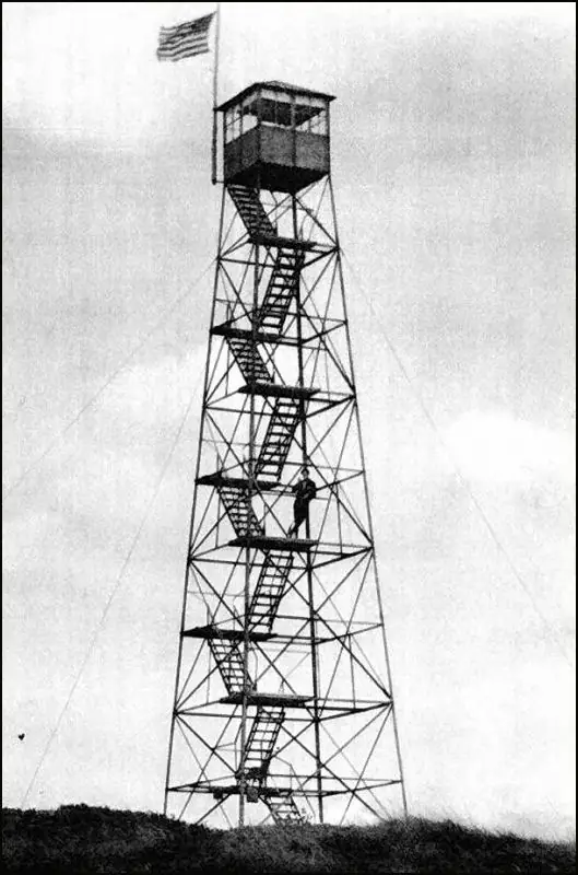
Alander Mountain (MA) tower built 1928 by Taconic State Park Commission; moved to Washburn Mtn in 1933 and to Beebe Hill State Forest, NY, in 1963 (sources differ on the year).
- Gone
- Open to the public
- Verified
Gone: The lookout no longer stands. Only the site is left. Removed from Alander Mountain in 1930; the tower now stands at Beebe Hill State Forest, NY, where sources disagree on its current condition
Visit & stay
Gone: site only. The lookout no longer stands, so there is nothing to climb or rent. You may still be able to visit the site.
Access
Open to the public. Beebe Hill State Forest, where the moved tower stands, is public state land with trails; no source says the tower itself may be climbed. The Alander Mountain site is gone and no access is described there.
- Road to the top?
- Unknown
- Trail
- A main trail in Beebe Hill State Forest passes the tower; a lean-to near the trail is open for public use
Facts
- Status
- Type
- Cab on a towerAermotor LS-40 60' towerThe design: Aermotor LS-40
- Built of
- SteelGoing by its design; no source says so in words.
- Built
- 1928
- Height
- 60 ft (18.3 m)
- Elevation
- 2,145 ft (654 m)
- Agency
- Alander Mt
- Land
- Unknown
- Location
- Berkshire County, Massachusetts
- Coordinates
- 42.09250, −73.50444 sources disagree
- Registers
- This entry
- VerifiedResearched, then checked independently. Updated 9 Oct 2026.
- Firefinder id
us-ma-alander-mountain
View from the cab
What the lookout saw from its cab: every ridge out to about 93 miles, the named peaks in sight, and other fire lookouts within view, worked out from terrain data in your browser.
This lookout is gone. The view is reconstructed from its recorded site and its recorded height.
Downloads about 3.8 MB of terrain data the first time.
Or see what it could see on the map: the ground in its line of sight.
History
Then and now
- 1928 BuiltTaconic State Park Commission erected a 60-foot Aermotor LS-40 tower on Alander Mtn. to detect fires on park landSource: firetower.org
- 1930 FireThe area at Alander Mtn. burned; the 1930 report to the NY Legislature credited the tower with 24 fires while the Park Commission ran itSources: firetower.org, easternuslookouts.weebly.com
- 1930 RemovedLandowner asked for removal (register); the lease ended and the tower was dismantled and stored (register: High Falls facility; hobbyist page: park storage area until 1932)Sources: firetower.org, easternuslookouts.weebly.com
- 1933 MovedRe-erected on Washburn Mountain in Columbia County, NY, inside park boundariesSources: firetower.org, easternuslookouts.weebly.com, en.wikipedia.org
- 1935 StaffedForest Fire Control took over operation at Washburn about 1935; operated there until 1963Source: firetower.org
- No record between 1935 and 1963
- 1963 MovedNovember 1963: dismantled by Forest Rangers, flown by helicopter to Beebe Hill and re-erected. The hobbyist page and Wikipedia give 1964Sources: firetower.org, nhlr.org, easternuslookouts.weebly.com
- No record between 1963 and 1987
- 1987 ClosedLast operated at Beebe Hill; closed in 1987Sources: nhlr.org, en.wikipedia.org
- 1997 EventLocal residents, the Forest Fire Lookout Association and NYSDEC began efforts to restore the tower and establish hiking accessSource: en.wikipedia.org
- 2009 Added to the Former Fire Lookout Sites RegisterDate registered October 6, 2009 (FFLOS US 544, MA 54)Source: firetower.org
- No record between 2009 and 2024
- 2024 Condition assessmentWikipedia: as of late 2024 the Beebe Hill tower was deemed unsafeSource: en.wikipedia.org
- 2025 RestoredAs of 2025 the Beebe Hill tower was recently restored; wooden stairs replaced with metalSource: nhlr.org
- TodayGoneThe lookout no longer stands. Only the site is left.
Old maps of this spot
USGS topographic maps from the years a lookout stood may show it, often as a small symbol labelled “Lookout”. See the old topo maps around it on the Firefinder map, or find every scanned sheet of this spot on USGS TopoView (opens another site) (click the spot there to list them, with dates and downloads).
Story
Researched 9 Oct 2026, fact-checked.
Alander Mountain sits in Berkshire County, Massachusetts, about a quarter mile east of the New York line.1,2 In 1928 the Taconic State Park Commission put up a 60-foot Aermotor tower there to spot fires on park land.1 The site was on leased private land.2 A 1930 report to the New York Legislature credited the tower with 24 fires while the Park Commission ran it.2
The land burned in 1930, and the owner asked that the tower be taken away.1 Park staff took it down and stored it, after the landowner ended the lease.1,2 The tower went back up on Washburn Mountain, in Columbia County, New York, in 1933.1,2,3 The register says the Park put it up, while the hobbyist page says the state Conservation Department did.1,2
Forest Fire Control took over running the tower about 1935 and operated it there until 1963.1 In November 1963 Forest Rangers took it down and flew it by helicopter to Beebe Hill, where it was put back up.1,4 The hobbyist page and Wikipedia both give 1964 for that move.2,3
Beebe Hill is in Beebe Hill State Forest, in the town of Austerlitz, Columbia County, New York.4,3 The tower closed in 1987. In 1997 local residents, the Forest Fire Lookout Association and the New York State Department of Environmental Conservation began efforts to restore it.4,3
The sources disagree about its recent condition. Wikipedia says it was deemed unsafe as of late 2024, while the register says it was recently restored as of 2025, with metal now replacing the wooden stairs.3,4 A hobbyist page reports that restoration is finished and the tower is open for visits.2 No source here settles which account is current. The state forest's main trail has a lean-to near the tower that is open to the public.3 The sources do not say whether the tower itself can be climbed, so check with the New York Department of Environmental Conservation, which administers the site, before going up.4
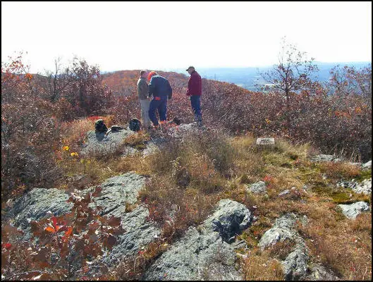
Alander Mountain itself is listed as gone, and no source I read describes what, if anything, remains there.5,1
- Alander Mountain Tower Site, Former Fire Lookout Sites Register, http://firetower.org/lookouts/us/ma/alander-mountain-tower-site/ (accessed 2026-10-09). ↩
- Alander Mountain, Forest Lookouts, https://easternuslookouts.weebly.com/alander-mountain.html (accessed 2026-10-09). ↩
- Beebe Hill State Forest, Wikipedia, https://en.wikipedia.org/wiki/Beebe_Hill_State_Forest (accessed 2026-10-09). ↩
- Beebe Hill Fire Tower, National Historic Lookout Register, http://nhlr.org/lookouts/us/ny/beebe-hill-fire-tower/ (accessed 2026-10-09). ↩
- Lookout Structures, New York, Forest Fire Lookout Association, https://firelookout.org/lookouts/us/ny/ (accessed 2026-10-09). ↩
Photos
Photos keep their own rights and are shown with credit. Is one of these yours? You can ask for a different credit or for removal.
Where sources disagree
We show disagreements between sources instead of quietly picking one. If you know which is right, please tell us.
Sources disagree on the location by 550 m.
- FFLOS: 42.09250, −73.50444
- FOREST LOOKOUTS -- eastern US (easternuslookouts.weebly.com): 42.08759, −73.50512
The map uses the position from FFLOS.
Sources
- Former Fire Lookout Sites Register (FFLOS) (opens another site) Gave us: name, location, county, elevation, what it is built of, register numbers, dates, photos, links Former Fire Lookout Sites Register (firetower.org) · All rights reserved (American Resources, Inc.); facts extracted only, no prose copied. · retrieved 4 Oct 2026
- Forest Fire Lookout Association (FFLA) - US lookout lists (opens another site) Gave us: type, status, links Forest Fire Lookout Association (firelookout.org) · No licence stated; facts extracted only, no prose copied. · retrieved 8 Oct 2026
- FOREST LOOKOUTS -- eastern US (easternuslookouts.weebly.com) (opens another site) Gave us: agency, links easternuslookouts.weebly.com · No licence stated; facts only (county, coordinates where the page's own map widget gives them, status, height, design hints, register links). The site's own historical quotes, newspaper citations and narrative are not reproduced. · retrieved 8 Oct 2026
- Firefinder research Gave us: summary, design, height, status, access, visiting details, dates, links, fact-check Firefinder research (sources cited in the story footnotes) · Our own research notes; each fact cites its source in the lookout's story
More about this lookout elsewhere
- FFLOS register entry US 544 (firetower.org) (opens another site)
- Beebe Hill Fire Tower (National Historic Lookout Register (nhlr.org)) (opens another site)
- Beebe Hill State Forest (Wikipedia) (opens another site)
- FFLA New York lookout list (firelookout.org) (opens another site)
- Alander Mountain (easternuslookouts.weebly.com) (opens another site)
Firefinder takes facts (places, dates, numbers) from these sources and writes its own words. See all sources and licences.