Fire lookout · Worcester County, Massachusetts
Charlton Fire Tower
Little Mugget Hill lookout in Charlton: a 1917-18 tower lost to the 1938 hurricane, a 1939 CCC-built replacement, and a 2016 state listing of standing and active.
- Standing
- Restricted access
- Verified
Visit & stay
Not rentable. As far as we know, this lookout cannot be booked for overnight stays.
Access
Restricted access
Access is seasonal, gated or needs a permit. Check before you go. Mass.gov says state fire observation towers are not open to the general public; no visitor or rental information found for this tower.
- Can you climb it?
- Unknown
- Road to the top?
- Unknown
- Staffing
- Unknown
Facts
- Status
- Type
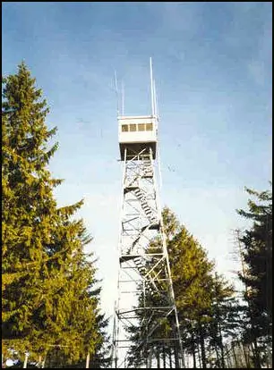
- Cab on a tower60-foot Aermotor steel tower with a 10x10-foot wood cab (registry); FFLA gives a 68-foot structure heightThe design: Aermotor
- Built of
- Steel
- Built
- 1917
- Height
- Unknown
- Elevation
- 574 ft (175 m)
- Agency
- Massachusetts Bureau of Forest Fire Control
- Land
- Unknown
- Location
- Worcester County, Massachusetts
- Coordinates
- 42.16833, −71.83861
- Registers
- This entry
- VerifiedResearched, then checked independently. Updated 8 Oct 2026.
- Firefinder id
us-ma-charlton
View from the cab
What you see from the cab: every ridge out to about 93 miles, the named peaks in sight, and other fire lookouts within view, worked out from terrain data in your browser.
Downloads about 3.4 MB of terrain data the first time.
Or see what it could see on the map: the ground in its line of sight.
History
Then and now
- 1914 EventSite first used for fire detection; watched from the ground in a grassy pasture until a tower went upSources: nhlr.org, firelookout.ipage.com
- 1917 BuiltFirst tower: registry says 48 ft built 1917; 1917 state report says 50 ft; FFLA dates it 1918Sources: nhlr.org, firelookout.ipage.com, easternuslookouts.weebly.com
- No record between 1917 and 1938
- 1938 DestroyedDestroyed in the Great New England Hurricane, September 21, 1938Sources: nhlr.org, firelookout.ipage.com, easternuslookouts.weebly.com
- 1939 Built'Built' field on NHLR detail pageSource: NHLR register entry
- 1939 Replaced by a new structureCCC-built replacement, 60-foot Aermotor steel tower with 10x10 wood cab; FFLA credits the US Forest Service with supplying itSources: nhlr.org, firelookout.ipage.com, easternuslookouts.weebly.com
- 1951 AlteredNew road to the towerSource: firelookout.ipage.com
- No record between 1951 and 1966
- 1966 AlteredNew cab and chain link fenceSource: firelookout.ipage.com
- No record between 1966 and 2004
- 2004 Added to the National Historic Lookout RegisterRegistered June 30, 2004 as US 587, MA 14; nominated by Henry IsenbergSource: nhlr.org
- 2015 Condition assessmentState maintenance crew inspected the tower for possible future repairSource: firelookout.org
- 2016 EventState listing (last updated 5/8/2016) shows the tower standing and activeSource: firelookout.ipage.com
- TodayStandingIt still stands, as far as our sources know.
Old maps of this spot
USGS topographic maps from the years a lookout stood may show it, often as a small symbol labelled “Lookout”. See the old topo maps around it on the Firefinder map, or find every scanned sheet of this spot on USGS TopoView (opens another site) (click the spot there to list them, with dates and downloads).
Story
Researched 9 Oct 2026, fact-checked.
Little Mugget Hill in Charlton was first used for fire detection in 1914.1 Before a tower stood there, the state watched from the ground, from a grassy pasture with a wide outlook.2 The first tower went up in 1917 or 1918, and the sources disagree on its height.1,2,3 The registry gives 48 feet, while a 1917 state forester report puts it at 50 feet, with stairs.1,3 Neighboring towns helped pay for it, and the station was meant to cover roughly 150,000 acres of forest.3
The September 1938 hurricane destroyed that first tower.1,2,3 In 1939 Civilian Conservation Corps workers built its replacement: a steel Aermotor tower 60 feet high, with a wood cab measuring 10 by 10 feet.1,3 The FFLA page credits the US Forest Service with supplying the tower, and it lists the structure at 68 feet, so the height is disputed.2
A road to the tower was built in 1951, and a new cab and a chain-link fence went up in 1966.2 In 2015 the state's forest fire control maintenance crew inspected the tower to see whether it would need repairs later.4 I found no staffing history for it in these sources.
A state listing last updated in May 2016 marks the tower as standing and active.5 The FFLA page also says the state still keeps it in service, but I found no current information about visits or rentals.2 A state plan for fire observation towers says they are closed to the public and are not meant for recreation.6 Please don't climb it without permission. The Massachusetts Bureau of Forest Fire Control administers the tower, so that is the office to ask.1
- Charlton Fire Tower, National Historic Lookout Register, http://nhlr.org/lookouts/us/ma/charlton-fire-tower/ (accessed 2026-10-09). ↩
- Massachusetts Fire Towers - Charlton, Forest Fire Lookout Association, https://firelookout.ipage.com/lookouts/ma/charlton.htm (accessed 2026-10-09). ↩
- Massachusetts - Forest Lookouts, Forest Lookouts, https://easternuslookouts.weebly.com/massachusetts.html (accessed 2026-10-09). ↩
- Southern New England Chapter report for 2015, firelookout.org, https://firelookout.org/wp-content/uploads/2024/11/cr-sne-2015.pdf (accessed 2026-10-09). ↩
- Massachusetts Fire Towers - State Listing Page, Forest Fire Lookout Association, https://firelookout.ipage.com/lookouts/ma/mass.htm (accessed 2026-10-09). ↩
- Section 15. Fire Observation Towers, Commonwealth of Massachusetts (mass.gov), https://www.mass.gov/doc/section-15-fire-observation-towers/download (accessed 2026-10-09). ↩
Photos
Photos keep their own rights and are shown with credit. Is one of these yours? You can ask for a different credit or for removal.
Sources
- National Historic Lookout Register (NHLR) (opens another site) Gave us: name, location, county, elevation, type, what it is built of, status, register numbers, agency, dates, photos, links National Historic Lookout Register (nhlr.org) · All rights reserved (American Resources, Inc.); facts extracted only, no prose copied. · retrieved 4 Oct 2026
- Forest Fire Lookout Association chapter reports (opens another site) Gave us: dates, links Forest Fire Lookout Association, chapter and restoration-grant reports (firelookout.org) · No licence stated; facts only (dates, names, the kind of work done). Every note is our own wording and every event links to the FFLA report it comes from. Positions are copied from the NHLR, FFLOS and FFLA records. · retrieved 8 Oct 2026
- Firefinder research Gave us: summary, design, agency, access, dates, links, fact-check Firefinder research (sources cited in the story footnotes) · Our own research notes; each fact cites its source in the lookout's story
More about this lookout elsewhere
- NHLR register entry US 587 (nhlr.org) (opens another site)
- Massachusetts Fire Towers - Charlton (Forest Fire Lookout Association) (opens another site)
- Massachusetts - Forest Lookouts (Forest Lookouts (easternuslookouts.weebly.com)) (opens another site)
- Massachusetts Fire Towers - State Listing Page (Forest Fire Lookout Association) (opens another site)
- Section 15. Fire Observation Towers (Commonwealth of Massachusetts (mass.gov)) (opens another site)
- Forest Fire Lookout Association chapter reports: work on Charlton Fire Tower (opens another site)
Firefinder takes facts (places, dates, numbers) from these sources and writes its own words. See all sources and licences.