Fire lookout · Lake County, Minnesota
Finland Lookout Tower
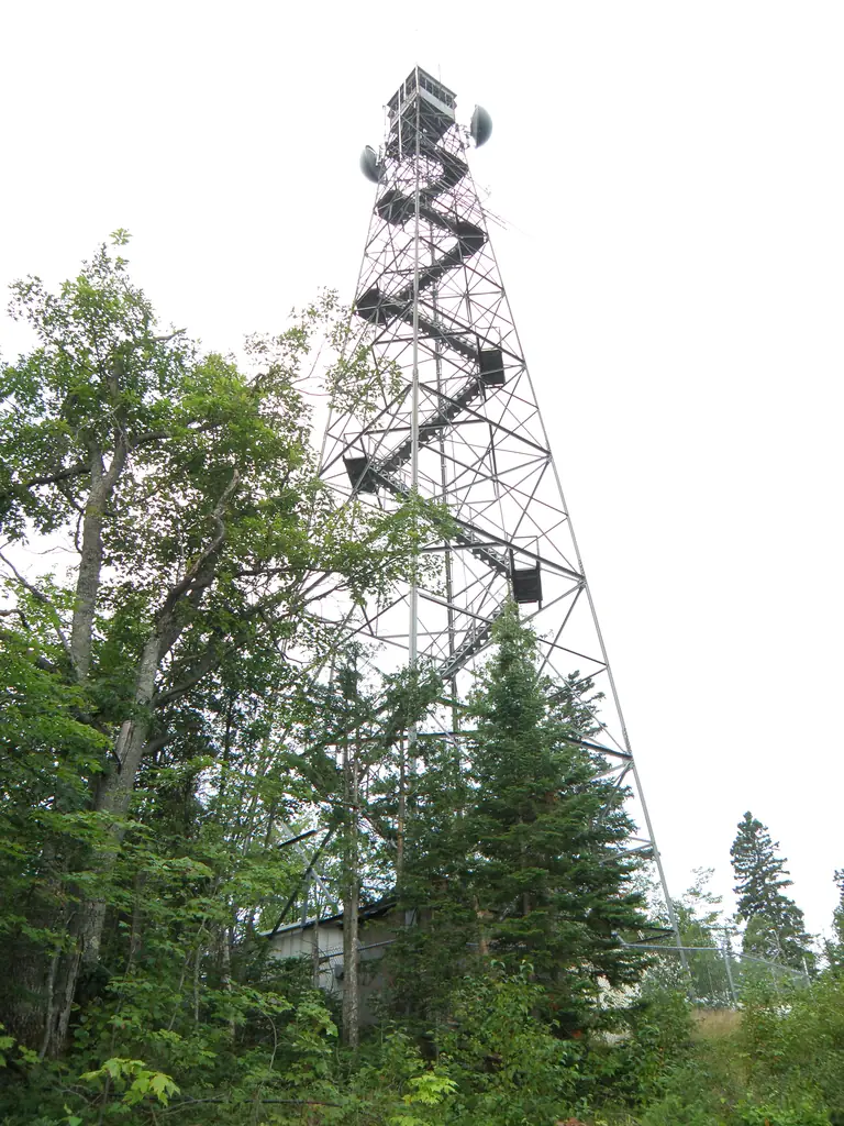
Lake County, MN: Lookout Tower #394, a 120-foot stairway tower built 1950, taken down in late June 2026 after falling into disrepair.
- Gone
- Access unknown
- Verified
Gone: The lookout no longer stands. Only the site is left. Taken down quietly in late June 2026 (Friends of Finland, July 2026); FFLA lists it as removed in 2026
Visit & stay
Gone: site only. The lookout no longer stands, so there is nothing to climb or rent.
Access
Access unknown
We do not know the access rules. Check with the land manager before you go.
- Road to the top?
- Unknown
Facts
- Status
- sources disagree
- Type
- Cab on a tower120-foot International Derrick stairway tower (#394)The design: IDECO
- Built of
- Not recorded
- Built
- 1950
- Height
- 120 ft (36.6 m)
- Elevation
- 1,883 ft (574 m)
- Agency
- Unknown
- Land
- Unknown
- Location
- Lake County, Minnesota
- Coordinates
- 47.45629, −91.23204
- Registers
- Not on a lookout register
- This entry
- VerifiedResearched, then checked independently. Updated 10 Oct 2026.
- Firefinder id
us-mn-finland
View from the cab
What the lookout saw from its cab: every ridge out to about 93 miles, the named peaks in sight, and other fire lookouts within view, worked out from terrain data in your browser.
This lookout is gone. The view is reconstructed from its recorded site and its recorded height.
Downloads about 3.8 MB of terrain data the first time.
Or see what it could see on the map: the ground in its line of sight.
History
Then and now
- 1950 BuiltLookout Tower #394 erected as a 120-foot International Derrick stairway towerSources: friendsoffinland.org, upload.wikimedia.org
- 1950 Replaced by a new structureReplaced the earlier 100-foot Aermotor tower #107, which was moved to the Askov site in 1951Source: upload.wikimedia.org
- No record between 1950 and 2026
- 2026 RemovedTaken down quietly in late June 2026 after falling into disrepairSources: friendsoffinland.org, firelookout.org
- TodayGoneThe lookout no longer stands. Only the site is left.
Old maps of this spot
USGS topographic maps from the years a lookout stood may show it, often as a small symbol labelled “Lookout”. See the old topo maps around it on the Firefinder map, or find every scanned sheet of this spot on USGS TopoView (opens another site) (click the spot there to list them, with dates and downloads).
Story
Researched 10 Oct 2026, fact-checked.
The Finland lookout, in Lake County, was built in 1950 as Lookout Tower #394.1,2,3 It was a 120-foot International Derrick stairway tower.2 It replaced an earlier 100-foot Aermotor tower, #107, which was moved to the Askov site in 1951.2
According to the Friends of Finland, after 76 years newer technology had left the tower no longer serving its purpose, and its condition had become unsafe.1 The group reported in July 2026 that the tower was quietly taken down in late June.1 The Forest Fire Lookout Association lists the tower as removed in 2026.4
An OpenStreetMap point for a Finland Lookout Tower still exists, but it was last edited about six years ago, before the removal.5
Wikidata lists the tower as lying within Finland State Forest.3 The Friends also posted images taken before, during and after the demolition, but their text does not say what remains on the site.1 We found no source saying whether the site is open to the public.1,4,3
- Saying Goodbye to the Finland Fire Tower, Friends of the Finland Community, https://friendsoffinland.org/saying-goodbye-to-the-finland-fire-tower/ (accessed 2026-10-10). ↩
- Minnesota Fire Lookout Towers, A to Z list, Wikimedia Commons, https://upload.wikimedia.org/wikipedia/commons/9/9f/A-Z_List-Towers.pdf (accessed 2026-10-10). ↩
- Finland Lookout Tower, Wikidata, https://www.wikidata.org/wiki/Q107494747 (accessed 2026-10-10). ↩
- Minnesota Lookouts, Forest Fire Lookout Association, https://firelookout.org/lookouts/us/mn/ (accessed 2026-10-10). ↩
- Finland Lookout Tower, OpenStreetMap node 7887760581, https://www.openstreetmap.org/node/7887760581 (accessed 2026-10-10). ↩
Photos

Photos keep their own rights and are shown with credit. Is one of these yours? You can ask for a different credit or for removal.
Where sources disagree
We show disagreements between sources instead of quietly picking one. If you know which is right, please tell us.
Sources disagree on whether it still stands.
- FFLA: Gone
- OpenStreetMap: Standing
Sources
- Forest Fire Lookout Association (FFLA) - US lookout lists (opens another site) Gave us: name, location, county, type, status, dates, links Forest Fire Lookout Association (firelookout.org) · No licence stated; facts extracted only, no prose copied. · retrieved 8 Oct 2026
- Wikidata -- US fire lookout towers (Q748998 and subclasses) (opens another site) Gave us: elevation, photos, links Wikidata · CC0 1.0 (Wikidata). Images keep their own Commons licence/credit. · retrieved 4 Oct 2026
- OpenStreetMap -- fire lookout structures (opens another site) Gave us: links © OpenStreetMap contributors · ODbL 1.0. (c) OpenStreetMap contributors. · retrieved 4 Oct 2026
- Firefinder research Gave us: summary, design, height, status, dates, links, fact-check Firefinder research (sources cited in the story footnotes) · Our own research notes; each fact cites its source in the lookout's story
More about this lookout elsewhere
- Saying Goodbye to the Finland Fire Tower (Friends of the Finland Community) (opens another site)
- Minnesota Fire Lookout Towers, A to Z list (Wikimedia Commons) (opens another site)
- FFLA Minnesota lookout list (firelookout.org) (opens another site)
- Wikidata item Q107494747 (opens another site)
- OpenStreetMap node 7887760581 (opens another site)
Firefinder takes facts (places, dates, numbers) from these sources and writes its own words. See all sources and licences.