Fire lookout · Flathead County, Montana
Black Butte Lookout
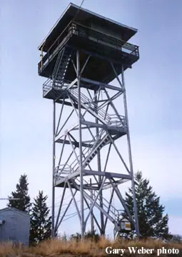
Kootenai NF lookout near Eureka, MT: a 1939 pole first tower, a 45-ft steel live-in tower built 1983, staffed in summer, reached by a locked-gate service road.
- Standing
- Restricted access
- Verified
Visit & stay
Not rentable. As far as we know, this lookout cannot be booked for overnight stays.
Access
Restricted access
Access is seasonal, gated or needs a permit. Check before you go. A locked gate blocks public motor vehicles on the service road, so visitors walk up. A 2022 visit found a sign listing open hours (9 AM to 6 PM, closed Wednesdays and Thursdays). Staffed each summer.
- Can you climb it?
- Unknown
- Road to the top?
- No, you have to hike
- Trail
- Park at the pullout before the locked gate on forestry road 7185 and walk the service road. Confirm open hours with the Kootenai National Forest; the 2022 visitor found the tower unmanned and climbing stopped at the stairs under the balcony.
- Staffing
- Unknown
Facts
- Status
- Type
- Cab on a tower45-foot all-steel live-in tower (1983); the first tower was a 35-foot pole L-4 (1939)The design: L-4
- Built of
- Steel
- Built
- 1939
- Height
- 45 ft (13.7 m)
- Elevation
- 6,841 ft (2,085 m)
- Agency
- US Forest Service, Kootenai National Forest
- Land
- Federal land
- Location
- Flathead County, Montana
- Coordinates
- 48.86454, −115.12528
- Registers
- This entry
- VerifiedResearched, then checked independently. Updated 8 Oct 2026.
- Firefinder id
us-mt-black-butte
View from the cab
What you see from the cab: every ridge out to about 93 miles, the named peaks in sight, and other fire lookouts within view, worked out from terrain data in your browser.
Downloads about 4.2 MB of terrain data the first time.
Or see what it could see on the map: the ground in its line of sight.
History
Then and now
- 1920 EventSite first used as a patrol point; the sources say only 'the 1920s'Sources: nhlr.org, firelookout.com
- No record between 1920 and 1939
- 1939 BuiltFirst tower: a 35-foot pole L-4Sources: nhlr.org, firelookout.com
- 1948 StaffedStanley Hanson working the lookout for the Forest Service, per a newspaper item quoted on Forest LookoutsSource: montanalookouts.weebly.com
- 1955 FireSmoker spot fire on Dodge Creek, under a hundredth of an acre; put out by a tanker truckSource: montanalookouts.weebly.com
- 1956 AlteredGap-filler radar station completed at the lookoutSource: montanalookouts.weebly.com
- 1957 StaffedManned in September 1957; the newspaper called it the only manned lookout in the Rexford areaSource: montanalookouts.weebly.com
- No record between 1957 and 1973
- 1973 Altered8x8 ft cab installed atop the radar installation, with no living quartersSources: nhlr.org, firelookout.com
- 1983 BuiltPresent 45-foot all-steel live-in towerSources: nhlr.org, firelookout.com
- No record between 1983 and 2021
- 2021 Added to the National Historic Lookout RegisterRegistered on the National Historic Lookout Register, January 9, 2021Source: nhlr.org
- TodayStandingIt still stands, as far as our sources know.
Old maps of this spot
USGS topographic maps from the years a lookout stood may show it, often as a small symbol labelled “Lookout”. See the old topo maps around it on the Firefinder map, or find every scanned sheet of this spot on USGS TopoView (opens another site) (click the spot there to list them, with dates and downloads).
Story
Researched 8 Oct 2026, fact-checked.
Black Butte sits in the Kootenai National Forest, about three miles southwest of Eureka, Montana.1 The first tower here was a 35-foot pole tower of the L-4 design, built in 1939. Before that, the spot was used for patrols in the 1920s.2,1
A man named Stanley Hanson was working the lookout for the Forest Service by 1948, according to a newspaper item quoted on the Montana Forest Lookouts site.3 In 1955 a spotter reported a fire on Dodge Creek and labelled it a smoker fire.3 The blaze stayed under a hundredth of an acre, and a tanker truck put it out.3 In 1956 a "gap filler" radar station was finished at the lookout.3 In 1957 a lookout was still manning the site, and the newspaper said it was the sole staffed lookout near Rexford.3
The register says an 8-by-8-foot cab was set on top of the radar installation in 1973, and it had no living quarters.2,1 The current tower, 45 feet tall, all-steel and live-in, went up in 1983.2,1 The register adds that someone staffs it every summer.2
The sources differ on two details. The register places the lookout in Flathead County, while the other three list Lincoln County.2,1,3,4 The register gives its elevation as 6,841 feet, but firelookout.com gives 4,064 feet.2,1
A locked gate stops public motor vehicles at the foot of the service road.5 A visitor in July 2022 walked up from the gate.5 That visitor saw a sign listing hours of 9 AM to 6 PM with no opening on Wednesdays or Thursdays, and found the tower unmanned that day, so climbing ended at the last flight of steps beneath the balcony.5 That sign detail is from one visit, so check with the Kootenai National Forest before you go, and do not climb the tower when it is closed or unstaffed.
- Black Butte Fire Lookout Tower, firelookout.com, https://www.firelookout.com/mt/blackbuttemt.html (accessed 2026-10-08). ↩
- Black Butte Lookout, National Historic Lookout Register, http://nhlr.org/lookouts/us/mt/black-butte-lookout/ (accessed 2026-10-08). ↩
- Black Butte, Forest Lookouts (Montana), https://montanalookouts.weebly.com/black-butte1.html (accessed 2026-10-08). ↩
- Montana Lookouts, Forest Fire Lookout Association, https://firelookout.org/lookouts/us/mt/ (accessed 2026-10-08). ↩
- Black Butte Lookout, sonnybou.ca, https://sonnybou.ca/ssbou2022/blackbuttelookout.html (accessed 2026-10-08). ↩
Photos
Photos keep their own rights and are shown with credit. Is one of these yours? You can ask for a different credit or for removal.
Sources
- National Historic Lookout Register (NHLR) (opens another site) Gave us: name, location, county, elevation, what it is built of, register numbers, agency, ownership, dates, photos, links National Historic Lookout Register (nhlr.org) · All rights reserved (American Resources, Inc.); facts extracted only, no prose copied. · retrieved 4 Oct 2026
- Forest Fire Lookout Association (FFLA) - US lookout lists (opens another site) Gave us: type, status, register numbers, links Forest Fire Lookout Association (firelookout.org) · No licence stated; facts extracted only, no prose copied. · retrieved 8 Oct 2026
- firelookout.com -- Rex Kamstra's Forest Fire Lookout Page (opens another site) Gave us: design, height, dates, photos, links firelookout.com · No licence stated on the site; facts only (coordinates, elevation, built/destroyed years, design, agency). Photos mirrored with the site's stated credit. · retrieved 4 Oct 2026
- FOREST LOOKOUTS -- western US (Ron Kemnow's weebly sites) (opens another site) Gave us: links Ron Kemnow's Forest Lookouts sites (westlookouts, californialookouts, idaholookouts, montanalookouts, oregonlookouts and washingtonlookouts .weebly.com) · No licence stated; facts only (county, land manager, status word, coordinates where the page's own map widget gives them, township-range-section, height and design hints, links). The site's own newspaper quotes, citations and narrative are not reproduced. · retrieved 8 Oct 2026
- Firefinder research Gave us: summary, design, height, agency, access, visiting details, dates, links, fact-check Firefinder research (sources cited in the story footnotes) · Our own research notes; each fact cites its source in the lookout's story
More about this lookout elsewhere
- NHLR register entry US 1503 (nhlr.org) (opens another site)
- Black Butte Lookout (sonnybou.ca (visitor account, July 2022)) (opens another site)
- FFLA Montana lookout list (firelookout.org) (opens another site)
- Black Butte on firelookout.com (Rex Kamstra) (opens another site)
- Black Butte on Forest Lookouts, western US (Ron Kemnow) (opens another site)
Firefinder takes facts (places, dates, numbers) from these sources and writes its own words. See all sources and licences.