Fire lookout · Ravalli County, Montana
Boulder Point Lookout
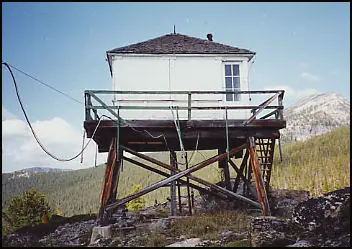
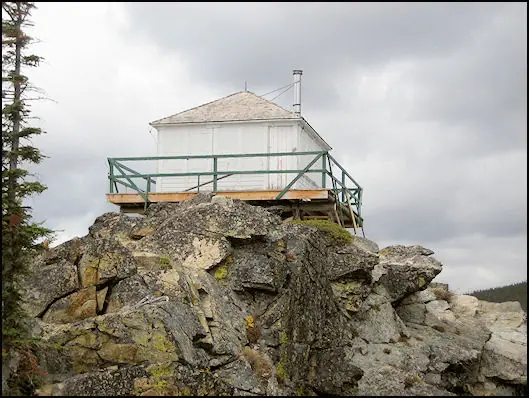
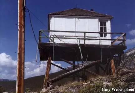
A 1937 L-4 cab on a 10-foot log tower in the Bitterroot National Forest, restored in 2003 by a ski club with Forest Service staff, reached by a two-mile pack trail.
- Standing
- Open to the public
- Verified
Visit & stay
Not rentable. As far as we know, this lookout cannot be booked for overnight stays.
Access
Open to the public. Remote. The only access is a two-mile pack trail on Bitterroot National Forest land. No source says the lookout is open for climbing or overnight use.
- Can you climb it?
- Unknown
- Road to the top?
- Unknown
- Trail
- Two-mile pack trail, the only access per the nomination. The register says locals find the site popular for summer hikes and winter ski-ins.
- Staffing
- Not staffed (as of mid-1980s)
Facts
- Status
- Type
- Cab on a towerL-4 cab, 14x14 ft wood frame with pyramidal roof, on a 10-ft log tower; 1931-pattern designed by Clyde FickesThe design: L-4
- Built of
- Wood
- Built
- 1937
- Height
- 10 ft (3.0 m)
- Elevation
- 7,688 ft (2,343 m)
- Agency
- U.S. Forest Service, Bitterroot National Forest (West Fork Ranger District)
- Land
- Federal land
- Location
- Ravalli County, Montana
- Coordinates
- 45.83737, −114.28933 sources disagree
- Registers
- This entry
- VerifiedResearched, then checked independently. Updated 8 Oct 2026.
- Firefinder id
us-mt-boulder-point
View from the cab
What you see from the cab: every ridge out to about 93 miles, the named peaks in sight, and other fire lookouts within view, worked out from terrain data in your browser.
Downloads about 4.1 MB of terrain data the first time.
Or see what it could see on the map: the ground in its line of sight.
History
Then and now
- 1931 Event1931-pattern L-4 lookout house, originally designed by Clyde FickesSource: npgallery.nps.gov
- 1937 BuiltL-4 cab on a 10-ft tower, per the register and firelookout.comSources: nhlr.org, firelookout.com
- No record between 1937 and 1958
- 1958 StaffedFirst lookout personnel entry on firelookout.com's listSource: firelookout.com
- No record between 1958 and 1985
- 1985 Last staffedStaffed into the mid-1980s per firelookout.com; the register says in service until the 1980s. Year is approximateSources: nhlr.org, firelookout.com
- No record between 1985 and 2003
- 2003 RestoredRestoration completed in July 2003 by the West Fork Ski Club with active and retired Forest Service personnelSource: nhlr.org
- 2004 Added to the National Historic Lookout RegisterRegistered February 12, 2004 as US 543, MT 38Source: nhlr.org
- TodayStandingIt still stands, as far as our sources know.
Old maps of this spot
USGS topographic maps from the years a lookout stood may show it, often as a small symbol labelled “Lookout”. See the old topo maps around it on the Firefinder map, or find every scanned sheet of this spot on USGS TopoView (opens another site) (click the spot there to list them, with dates and downloads).
Story
Researched 8 Oct 2026, fact-checked.
Boulder Point Lookout stands on a narrow, rocky point in the Bitterroot National Forest, in Ravalli County, Montana, roughly two miles northwest of the West Fork Ranger Station.1,2 The register gives its elevation as 7,688 feet, while firelookout.com gives 7,753 feet.1,3
The cab was built in 1937.1,3 The National Register nomination calls it a 14-by-14-foot wood-frame cab with a pyramidal roof, set atop a 10-foot log tower.2 Its design follows the 1931 pattern for Forest Service L-4 lookouts, which the nomination says was originally designed by Clyde Fickes.2 The nomination places the lookout in a multiple-property listing of L-4 lookouts in the Northern Region from 1932 to 1967.2
Firelookout.com says the lookout was staffed into the mid-1980s, and it lists known lookout personnel going back to 1958.3 The register says it was in service until the 1980s.1
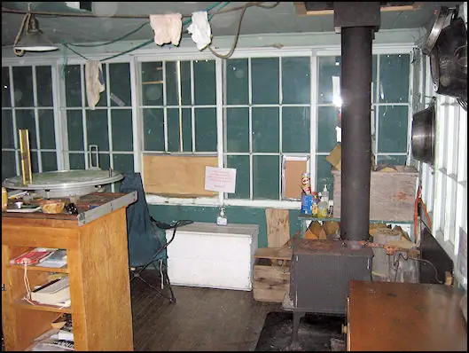
In July 2003, the West Fork Ski Club worked with active and retired Forest Service staff from the Bitterroot National Forest to restore the lookout, and the register added it on February 12, 2004.1 The nomination calls the lookout's condition good to fair.2 It describes some missing window panes, shutters that have been removed but remain on site, and a missing trapdoor that would have secured the tower.2
Getting there takes some effort. The nomination says the only access is a two-mile pack trail.2 The register says locals find the site popular for summer hikes and winter ski-ins.1 Firelookout.com describes the lookout as presently abandoned, without dating that note.3 The National Park Service's database lists it under number 100002044.4 Nothing here says the tower is open for climbing or overnight use, so check with the Bitterroot National Forest before going up.
- Boulder Point Lookout, National Historic Lookout Register, http://nhlr.org/lookouts/us/mt/boulder-point-lookout/ (accessed 2026-10-08). ↩
- Boulder Point Lookout, National Register of Historic Places nomination (NPGallery PDF), https://npgallery.nps.gov/GetAsset/daa9d4c9-14bc-4f69-9a13-9f682d6b7888 (accessed 2026-10-08). ↩
- Boulder Point Fire Lookout Tower, firelookout.com, https://www.firelookout.com/mt/boulderpt.html (accessed 2026-10-08). ↩
- Boulder Point Lookout, NPGallery asset detail, https://npgallery.nps.gov/AssetDetail/NRIS/100002044 (accessed 2026-10-08). ↩
Photos
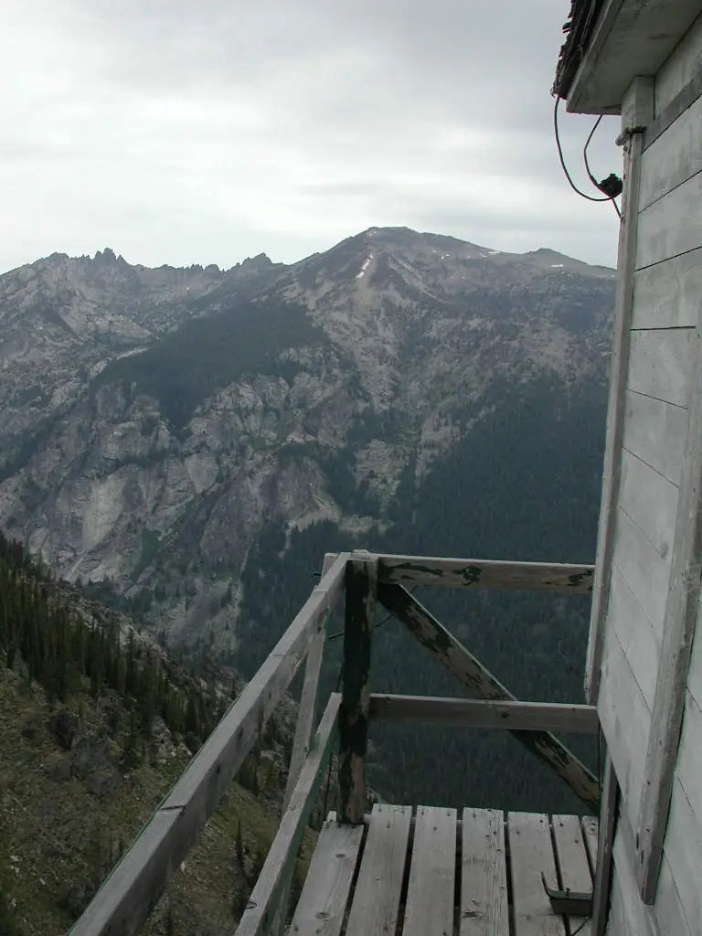

Photos keep their own rights and are shown with credit. Is one of these yours? You can ask for a different credit or for removal.
Where sources disagree
We show disagreements between sources instead of quietly picking one. If you know which is right, please tell us.
Sources disagree on the location by 1.5 km (0.9 mi).
- NHLR: 45.83737, −114.28933
- recreation.gov: 45.82449, −114.29445
The map uses the position from NHLR.
Sources
- National Historic Lookout Register (NHLR) (opens another site) Gave us: name, location, county, elevation, register numbers, agency, dates, photos, links National Historic Lookout Register (nhlr.org) · All rights reserved (American Resources, Inc.); facts extracted only, no prose copied. · retrieved 4 Oct 2026
- Forest Fire Lookout Association (FFLA) - US lookout lists (opens another site) Gave us: type, status, register numbers, links Forest Fire Lookout Association (firelookout.org) · No licence stated; facts extracted only, no prose copied. · retrieved 8 Oct 2026
- Recreation Information Database (recreation.gov) (opens another site) Gave us: ownership, access Data source: ridb.recreation.gov · Public data from the US government · retrieved 12 Oct 2026
- firelookout.com -- Rex Kamstra's Forest Fire Lookout Page (opens another site) Gave us: what it is built of, design, height, dates, photos, links firelookout.com · No licence stated on the site; facts only (coordinates, elevation, built/destroyed years, design, agency). Photos mirrored with the site's stated credit. · retrieved 4 Oct 2026
- Forest Fire Lookout Association chapter reports (opens another site) Gave us: dates, links Forest Fire Lookout Association, chapter and restoration-grant reports (firelookout.org) · No licence stated; facts only (dates, names, the kind of work done). Every note is our own wording and every event links to the FFLA report it comes from. Positions are copied from the NHLR, FFLOS and FFLA records. · retrieved 8 Oct 2026
- Wikidata -- US fire lookout towers (Q748998 and subclasses) (opens another site) Gave us: register numbers, photos, links Wikidata · CC0 1.0 (Wikidata). Images keep their own Commons licence/credit. · retrieved 4 Oct 2026
- FOREST LOOKOUTS -- western US (Ron Kemnow's weebly sites) (opens another site) Gave us: links Ron Kemnow's Forest Lookouts sites (westlookouts, californialookouts, idaholookouts, montanalookouts, oregonlookouts and washingtonlookouts .weebly.com) · No licence stated; facts only (county, land manager, status word, coordinates where the page's own map widget gives them, township-range-section, height and design hints, links). The site's own newspaper quotes, citations and narrative are not reproduced. · retrieved 8 Oct 2026
- Firefinder research Gave us: summary, design, height, agency, access, staffing, visiting details, dates, links, fact-check Firefinder research (sources cited in the story footnotes) · Our own research notes; each fact cites its source in the lookout's story
More about this lookout elsewhere
- NHLR register entry US 543 (nhlr.org) (opens another site)
- Boulder Point Lookout, National Register of Historic Places nomination (National Park Service, NPGallery) (opens another site)
- Boulder Point Lookout (asset detail) (National Park Service, NPGallery) (opens another site)
- FFLA Montana lookout list (firelookout.org) (opens another site)
- Forest Fire Lookout Association chapter reports: work on Boulder Point Lookout (opens another site)
- Boulder Point on firelookout.com (Rex Kamstra) (opens another site)
- Boulder Point on Forest Lookouts, western US (Ron Kemnow) (opens another site)
- Wikidata item Q86927810 (opens another site)
Firefinder takes facts (places, dates, numbers) from these sources and writes its own words. See all sources and licences.