Fire lookout · Sanders County, Montana
Cougar Peak Lookout
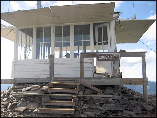
An L-4 ground house built in 1952 to replace a 1930 lookout, staffed into the mid-1980s, restored in 1995, and now a rentable NRHP-listed cabin.
- Standing
- Rentable
- Open to the public
- Verified
Visit & stay
You can rent this lookout for overnight stays through recreation.gov.
- Sleeps
- Up to 4 people
- Getting there
- The lookout can be accessed by vehicle, although late spring snow drifts may compromise parts of the road, requiring visitors to hike a short distance.
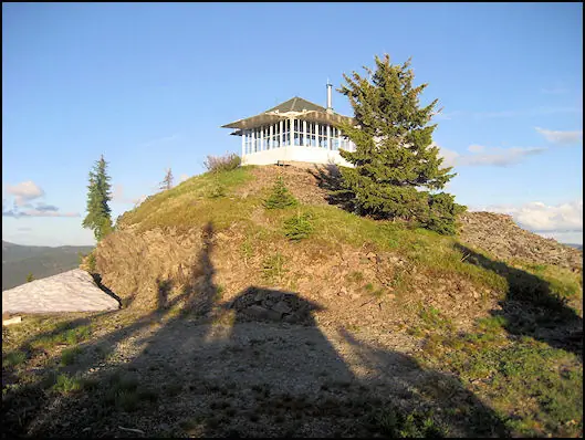
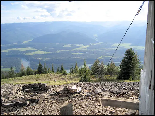
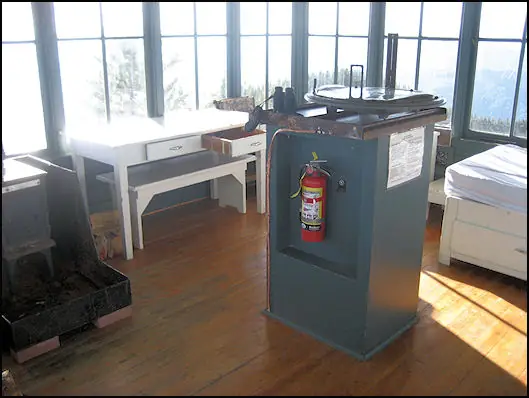
Overview The Cougar Peak Lookout offers guests an opportunity to experience an old-time Forest Service lookout. The tower commands an impressive view of the river valley, the surrounding Cabinet Mountains and the opposing Coeur d'Alene Mountains. The structure is small and is not elevated like many other lookouts. The lookout can be accessed by vehicle, although late spring snow drifts may compromise parts of the road, requiring visitors to hike a short distance. Guests are responsible for their own travel arrangements and safety, and must bring several of their own amenities. Recreation A variety of trails and points of exploration are accessible from the lookout. The Cougar Peak Trail follows the ridge below the lookout and travels towards Vermillion Pass to the northeast. The Clark Fork River is dammed twice within an hour drive of the lookout. The Noxon Rapids and the Cabinet Gorge dams create reservoirs that have become popular spots for boating and fishing for large and smallmouth bass, as well as northern pike. Facilities The 14-by-14 structure is small, but can accommodate up to four people. There is a full bed for two with a mattress pad, a table with two chairs, and a wood stove. No other furnishings are provided. A rustic outhouse with a vault toilet is available about 200 feet from the lookout, at the parking area. Guests will need to bring water for drinking, cooking and cleaning purposes, as well as their own bedding and cots for additional sleeping options, cooking and eating equipment and fuel, cooking and eating utensils, flashlights, matches and toilet paper, among other necessities. There is no water available at the site. There is room for a small tent outside the tower. Guests should be prepared for cold and often wet or damp weather, even if the weather in the valley is warm and dry. Food, garbage and other waste needs to be put away at all times to avoid attracting bears. Firewood may be collected locally for the wood stove. Natural Features The tower is situated in the Clark Fork River drainage, at an elevation of 6,694 feet, in the Cabinet Mountains of western Montana. It was built in 1952 to replace an existing, older structure dating back to the 1930s. The lookout was part of the old Cabinet National Forest, which was divided by the Forest Service in 1954 to become the Lolo National Forest. The 2 million-acre forest includes four wilderness areas and a wide variety of trees, plants and wildlife. The area is home to mountain goats, bighorn sheep, elk, moose, deer and grizzly and black bears (learn more about bear safety). Both the bald and golden eagle reside in the forest, along with trumpeter swan, herons and dozens of varieties of ducks. Contact Info For facility specific information, please call (406) 210-5287.
Book on recreation.gov (opens recreation.gov)
Rental details from recreation.gov, checked 19 Oct 2026. Rules, fees and seasons change, so confirm on the booking page before you go. Data source: ridb.recreation.gov
Access
Open to the public. Part of Forest Service cabin rental program on the Lolo National Forest.
- Can you climb it?
- No
- Road to the top?
- No, you have to hike
- Staffing
- Unknown
Facts
- Status
- Type
- Ground-level cabL-4 (hip-roof, 1936 standard model, ground house with catwalk)The design: L-4
- Built of
- WoodGoing by its design; no source says so in words.
- Built
- 1930 sources disagree
- Height
- 6,694 ft (2040.3 m)
- Elevation
- 6,694 ft (2,040 m)
- Agency
- U.S. Forest Service, Lolo National Forest
- Land
- Federal land
- Location
- Sanders County, Montana
- Coordinates
- 47.74472, −115.38361
- Registers
- This entry
- VerifiedResearched, then checked independently. Updated 19 Oct 2026.
- Firefinder id
us-mt-cougar-peak
View from the cab
What you see from the cab: every ridge out to about 93 miles, the named peaks in sight, and other fire lookouts within view, worked out from terrain data in your browser.
Downloads about 4.1 MB of terrain data the first time.
Or see what it could see on the map: the ground in its line of sight.
History
Then and now
- 1930 BuiltFirst lookout: an L-4 cab with gable roof.Sources: nhlr.org, firelookout.com
- No record between 1930 and 1952
- 1952 Built'Built' field on NHLR detail pageSource: NHLR register entry
- 1952 Replaced by a new structurePresent hip-roof L-4 ground house with catwalk built, replacing the 1930 structure.Sources: nhlr.org, firelookout.com
- No record between 1952 and 1985
- 1985 Last staffedLast regularly staffed in the mid-1980s (exact year not specified by sources).Sources: nhlr.org, firelookout.com
- 1995 RestoredPassport in Time volunteer project reroofed the lookout and replaced/repaired windows and door.Sources: nhlr.org, firelookout.com
- 2009 Added to the National Historic Lookout RegisterAdded to the National Historic Lookout Register, April 24, 2009.Source: nhlr.org
- TodayStandingIt still stands, as far as our sources know.
Old maps of this spot
USGS topographic maps from the years a lookout stood may show it, often as a small symbol labelled “Lookout”. See the old topo maps around it on the Firefinder map, or find every scanned sheet of this spot on USGS TopoView (opens another site) (click the spot there to list them, with dates and downloads).
Story
Researched 4 Oct 2026, fact-checked.
Cougar Peak's first lookout went up in 1930, an L-4 cab with a gable roof on the Lolo National Forest overlooking the Clark Fork River Valley.1,2 That structure was replaced in 1952 by the hip-roof L-4 ground house with a surrounding catwalk that still stands today — the only one of its standard 1936 design left on the Lolo.1 The National Register of Historic Places lists Clyde Fickes, a Forest Service architect associated with many of the agency's standard lookout designs, in connection with the structure, with a period of significance running from 1952 to 1967.3
The lookout was staffed regularly into the mid-1980s.1,2 One of its more distinctive features isn't architectural but personal: rock carvings left on site by the lookouts who worked there over the decades, the earliest dated 1921, predating the current building by decades.1
In 1995, a Passport in Time volunteer project reroofed the cabin and replaced and repaired its windows and door, along with other repairs, helping keep the structure sound after staffing ended.1,2 Cougar Peak Lookout was added to the National Historic Lookout Register in 2009 and is separately listed on the National Register of Historic Places.1,3
The lookout is now part of the Forest Service's cabin rental program, bookable through Recreation.gov, and sits near the Cabinet Mountains Wilderness with views over the Clark Fork Valley.1,4 It sleeps up to four.4
- Cougar Peak Lookout, National Historic Lookout Register, http://nhlr.org/lookouts/us/mt/cougar-peak-lookout/ (accessed 2026-10-04). ↩
- Cougar Peak Lookout Tower, firelookout.com, https://www.firelookout.com/mt/cougarpk.html (accessed 2026-10-04). ↩
- Cougar Peak Lookout, National Register of Historic Places nomination (Asset ID 100002774), National Park Service NPGallery, https://npgallery.nps.gov/AssetDetail/NRIS/100002774 (accessed 2026-10-04). ↩
- Cougar Peak Lookout, Recreation.gov, https://www.recreation.gov/camping/campgrounds/234423 (accessed 2026-10-04). ↩
Photos
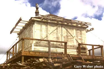
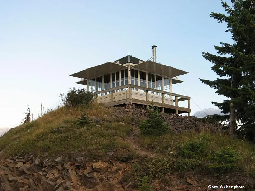
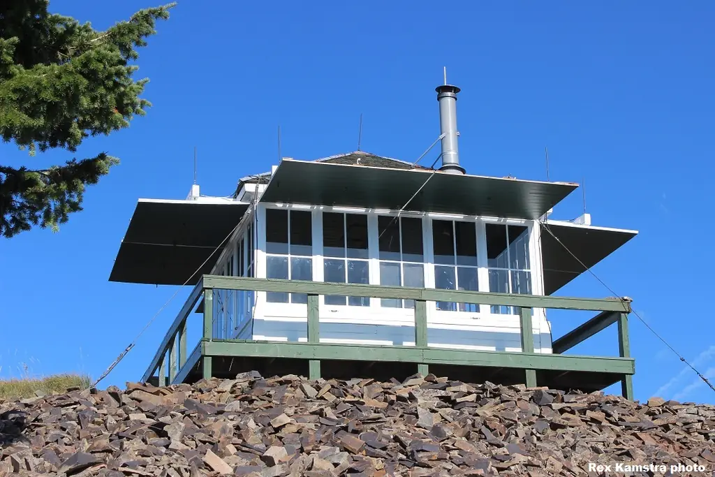
Photos keep their own rights and are shown with credit. Is one of these yours? You can ask for a different credit or for removal.
Where sources disagree
We show disagreements between sources instead of quietly picking one. If you know which is right, please tell us.
Sources disagree on the year it was built.
- NHLR: 1952
- firelookout.com -- Rex Kamstra's Forest Fire Lookout Page: 1930
- recreation.gov: 1952
- Wikidata: 1952
Sources give different build years. Often one counts the first lookout on the site and another the structure there now.
Sources
- National Historic Lookout Register (NHLR) (opens another site) Gave us: name, location, county, elevation, register numbers, agency, dates, photos, links National Historic Lookout Register (nhlr.org) · All rights reserved (American Resources, Inc.); facts extracted only, no prose copied. · retrieved 4 Oct 2026
- Forest Fire Lookout Association (FFLA) - US lookout lists (opens another site) Gave us: type, status, register numbers, links Forest Fire Lookout Association (firelookout.org) · No licence stated; facts extracted only, no prose copied. · retrieved 8 Oct 2026
- Recreation Information Database (recreation.gov) (opens another site) Gave us: ownership, access, rental details, links Data source: ridb.recreation.gov · Public data from the US government · retrieved 19 Oct 2026
- Forest Fire Lookout Association: lookout rentals (opens another site) Gave us: rental details, links Forest Fire Lookout Association rentals list (firelookout.org) · No licence stated; facts extracted only (state, name, booking link, manager, closure note), no prose copied. The FFLA says it is not involved in managing any rental program. · retrieved 19 Oct 2026
- firelookout.com -- Rex Kamstra's Forest Fire Lookout Page (opens another site) Gave us: what it is built of, design, photos, links firelookout.com · No licence stated on the site; facts only (coordinates, elevation, built/destroyed years, design, agency). Photos mirrored with the site's stated credit. · retrieved 4 Oct 2026
- Wikidata -- US fire lookout towers (Q748998 and subclasses) (opens another site) Gave us: register numbers, links Wikidata · CC0 1.0 (Wikidata). Images keep their own Commons licence/credit. · retrieved 4 Oct 2026
- OpenStreetMap -- fire lookout structures (opens another site) Gave us: links © OpenStreetMap contributors · ODbL 1.0. (c) OpenStreetMap contributors. · retrieved 4 Oct 2026
- FOREST LOOKOUTS -- western US (Ron Kemnow's weebly sites) (opens another site) Gave us: links Ron Kemnow's Forest Lookouts sites (westlookouts, californialookouts, idaholookouts, montanalookouts, oregonlookouts and washingtonlookouts .weebly.com) · No licence stated; facts only (county, land manager, status word, coordinates where the page's own map widget gives them, township-range-section, height and design hints, links). The site's own newspaper quotes, citations and narrative are not reproduced. · retrieved 8 Oct 2026
- Firefinder research Gave us: summary, design, height, status, agency, access, visiting details, dates, links, fact-check Firefinder research (sources cited in the story footnotes) · Our own research notes; each fact cites its source in the lookout's story
More about this lookout elsewhere
- NHLR register entry US 784 (nhlr.org) (opens another site)
- NHLR register entry (nhlr.org) (opens another site)
- Recreation.gov listing (opens another site)
- Cougar Peak Lookout (NRHP Reference #100002774) (National Park Service, NPGallery) (opens another site)
- FFLA Montana lookout list (firelookout.org) (opens another site)
- FFLA lookout rentals list (firelookout.org) (opens another site)
- Cougar Peak on firelookout.com (Rex Kamstra) (opens another site)
- Cougar Peak on Forest Lookouts, western US (Ron Kemnow) (opens another site)
- Wikidata item Q86928024 (opens another site)
- OpenStreetMap node 13907515719 (opens another site)
Firefinder takes facts (places, dates, numbers) from these sources and writes its own words. See all sources and licences.