Fire lookout · Sanders County, Montana
Gem Peak Lookout
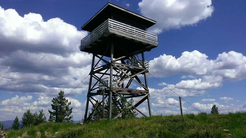
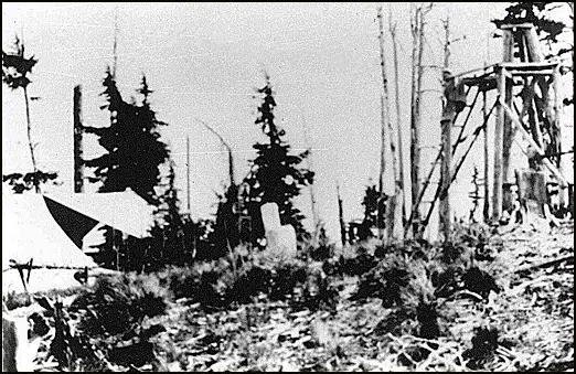
A 1921 'rag outfit' lookout on the Cabinet Ranger District, rebuilt in 1939 and again in 1964, staffed into the 1970s and now a recreation.gov rental.
- Standing
- Rentable
- Open to the public
- Verified
Visit & stay
You can rent this lookout for overnight stays through recreation.gov.
- Season
- to motorized use
- Sleeps
- Up to 4 people
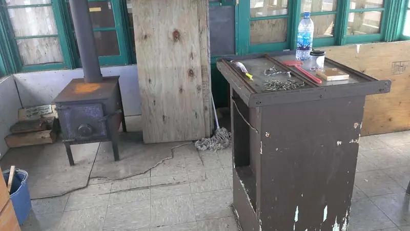
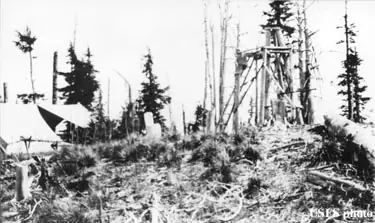
Overview The gem peak lookout is located in the Cabinet Ranger District, situated above the Clark Fork River Area at the southern end of the Cabinet Mountain Wilderness. The original Gem Peak Lookout was activated in 1921 as a "rag outfit"--a pole platform tent near a 15 foot open-platform tower. Today, the renovated structure includes a 225 square foot cabin atop a 30-foot tower with amenities such as a wood heating stove, single beds and of course, the incredible view of the Clark Fork River and the Noxon area. Full vehicle access depends on weather conditions, but typically visitors can drive straight to the lookout. Recreation The Cabinet Ranger District features almost half a million acres of National Forest lands offering a full range of year-round recreational opportunities. Approximately 400 miles of trail are available to the hiker, hunter, and stock user to access various lakes and scenic viewpoints. 150 miles of these trails are open to motorized use. The District maintains almost 400 miles of open road, and many miles of gated roads offer additional opportunities to mountain bikers, berry pickers, and hunters. There is a trailhead located near the lookout with access for both hiking and OHV riding. For more information on designated OHV-riding areas, Click here. Visitors may also enjoy seasonal Huckleberry picking in the land surrounding the lookout. Facilities The lookout can accommodate up to 4 people with two single beds plus mattresses, a table and chairs, a bench and a wood heating stove. The lookout is not wired for electricity, but it does come with firewood stored at the base of the tower. Guests will need to bring their own light source and cooking equipment. There is a vault toilet located outside. Potable water is not available at the tower; Visitors will need to bring enough drinking water for the extent of their stay. Cleaning equipment is provided and guests are expected to leave the tower in good condition upon departure. This is a "pack it in, pack it out" facility; trash collection is not provided. In addition to the above amenities, guests will need to bring a few of their own supplies to ensure a comfortable stay. Linens, pillows, cooking utensils, toilet paper, trash bags and food are not provided. Natural Features The Clark Fork River Area is bordered by the Idaho line on the west and the Cabinet Mountains Wilderness on the east. The Clark Fork River flows north and west through the District, and the Bull and Vermilion Rivers join it from the north. Rugged peaks ranging in elevation from 6,000-8,700 feet overlook the valley bottom. The Kootenai National Forest is dominated by a mixed conifer forest, but there is also an impressive ancient cedar grove set aside as a scenic area. In the spring and throughout the summer, a succession of wildflowers add color to hillsides and meadows and in the fall, stands of western larch and aspen mix yellows with the reds of huckleberry bushes, mountain maples and mountain ash.
Book on recreation.gov (opens recreation.gov)
Rental details from recreation.gov, checked 19 Oct 2026. Rules, fees and seasons change, so confirm on the booking page before you go. Data source: ridb.recreation.gov
Access
Open to the public. Overnight stays by reservation on recreation.gov; check the listing for road, trail and seasonal closures.
- Can you climb it?
- Yes
- Road to the top?
- Unknown
- Staffing
- Unknown
Facts
- Status
- Type
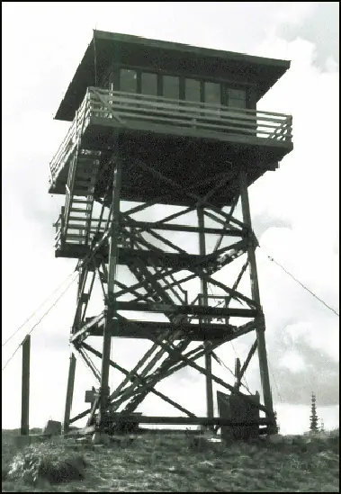
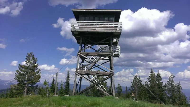
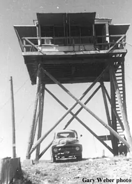
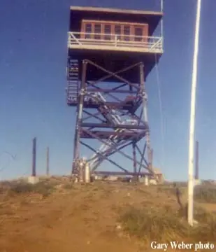
- Cab on a towerR-6 flattop cab with catwalk on a 30-foot treated timber towerThe designs: R-6, L-4
- Built of
- Wood
- Built
- 1921
- Height
- 20 ft (6.1 m)
- Elevation
- 6,029 ft (1,838 m)
- Agency
- U.S. Forest Service, Kootenai National Forest, Cabinet Ranger District
- Land
- Federal land
- Location
- Sanders County, Montana
- Coordinates
- 47.91352, −115.90675
- Registers
- This entry
- VerifiedResearched, then checked independently. Updated 19 Oct 2026.
- Firefinder id
us-mt-gem-peak
View from the cab
What you see from the cab: every ridge out to about 93 miles, the named peaks in sight, and other fire lookouts within view, worked out from terrain data in your browser.
Downloads about 4.1 MB of terrain data the first time.
Or see what it could see on the map: the ground in its line of sight.
History
Then and now
- 1921 BuiltActivated as a 'rag outfit': a pole platform tent near an open platform towerSources: nhlr.org, firelookout.com
- No record between 1921 and 1939
- 1939 Replaced by a new structureL-4 cab built on a 20-foot pole towerSources: nhlr.org, firelookout.com
- No record between 1939 and 1964
- 1964 BuiltSource: firelookout.com -- Rex Kamstra's Forest Fire Lookout Page
- 1964 Replaced by a new structureCurrent R-6 flattop cab with catwalk built on a 30-foot timber towerSources: nhlr.org, firelookout.com
- No record between 1964 and 1996
- 1996 Added to the National Historic Lookout RegisterRegistered August 20, 1996 as US 180 / MT 19, nominated by Gary Weber, FFLASource: nhlr.org
- TodayStandingIt still stands, as far as our sources know.
Old maps of this spot
USGS topographic maps from the years a lookout stood may show it, often as a small symbol labelled “Lookout”. See the old topo maps around it on the Firefinder map, or find every scanned sheet of this spot on USGS TopoView (opens another site) (click the spot there to list them, with dates and downloads).
Story
Researched 4 Oct 2026, fact-checked.
Gem Peak rises in the Kootenai National Forest, about eight miles southwest of Noxon, Montana.1 The U.S. Forest Service activated it as a lookout in 1921 with what the register calls a "rag outfit": a canvas shelter set up next to an open platform tower, meant for spotting smoke, not for living in.2,1 For nearly two decades it was the one lookout on the old Noxon Ranger District without a permanent place to sleep.2,1
In 1939 the Forest Service replaced the platform with an L-4 cab set on a 20-foot pole tower, finally giving the lookout a place to sleep as well as watch from.2,1 That structure lasted twenty-five years. In 1964 crews built the cab that stands today: an R-6 flattop cab with a catwalk, raised on a 30-foot treated timber tower.2,1
Gem Peak was staffed into the 1970s.2,1 Three of its fire watchers are known by name: Vic Six in 1959, Jan Fisher in 1961 and 1962, and Gary Meyer in 1967.1 After the Forest Service stopped staffing it, the tower was nominated to the National Historic Lookout Register by Gary Weber of the Forest Fire Lookout Association and registered on August 20, 1996, as US 180 (Montana 19).2
The lookout still stands on what is now the Cabinet Ranger District, one of three lookouts in the district offered through the Forest Service's overnight rental program.2 Reservations run through recreation.gov; check the current listing for road, trail, and seasonal conditions, since winter weather can close off access into the Cabinet Mountains country.
- Gem Peak Fire Lookout Tower, firelookout.com, https://www.firelookout.com/mt/gempeak.html (accessed 2026-10-04). ↩
- Gem Peak Lookout, National Historic Lookout Register, http://nhlr.org/lookouts/us/mt/gem-peak-lookout/ (accessed 2026-10-04). ↩
Photos
Photos keep their own rights and are shown with credit. Is one of these yours? You can ask for a different credit or for removal.
Sources
- National Historic Lookout Register (NHLR) (opens another site) Gave us: name, location, county, elevation, what it is built of, register numbers, agency, dates, photos, links National Historic Lookout Register (nhlr.org) · All rights reserved (American Resources, Inc.); facts extracted only, no prose copied. · retrieved 4 Oct 2026
- Forest Fire Lookout Association (FFLA) - US lookout lists (opens another site) Gave us: type, status, register numbers, links Forest Fire Lookout Association (firelookout.org) · No licence stated; facts extracted only, no prose copied. · retrieved 8 Oct 2026
- Recreation Information Database (recreation.gov) (opens another site) Gave us: ownership, access, rental details, links Data source: ridb.recreation.gov · Public data from the US government · retrieved 19 Oct 2026
- Forest Fire Lookout Association: lookout rentals (opens another site) Gave us: rental details, links Forest Fire Lookout Association rentals list (firelookout.org) · No licence stated; facts extracted only (state, name, booking link, manager, closure note), no prose copied. The FFLA says it is not involved in managing any rental program. · retrieved 19 Oct 2026
- firelookout.com -- Rex Kamstra's Forest Fire Lookout Page (opens another site) Gave us: design, height, dates, photos, links firelookout.com · No licence stated on the site; facts only (coordinates, elevation, built/destroyed years, design, agency). Photos mirrored with the site's stated credit. · retrieved 4 Oct 2026
- OpenStreetMap -- fire lookout structures (opens another site) Gave us: links © OpenStreetMap contributors · ODbL 1.0. (c) OpenStreetMap contributors. · retrieved 4 Oct 2026
- FOREST LOOKOUTS -- western US (Ron Kemnow's weebly sites) (opens another site) Gave us: links Ron Kemnow's Forest Lookouts sites (westlookouts, californialookouts, idaholookouts, montanalookouts, oregonlookouts and washingtonlookouts .weebly.com) · No licence stated; facts only (county, land manager, status word, coordinates where the page's own map widget gives them, township-range-section, height and design hints, links). The site's own newspaper quotes, citations and narrative are not reproduced. · retrieved 8 Oct 2026
- Firefinder research Gave us: summary, design, agency, access, visiting details, dates, links, fact-check Firefinder research (sources cited in the story footnotes) · Our own research notes; each fact cites its source in the lookout's story
More about this lookout elsewhere
- NHLR register entry US 180 (nhlr.org) (opens another site)
- NHLR register entry (nhlr.org) (opens another site)
- Recreation.gov listing (opens another site)
- FFLA Montana lookout list (firelookout.org) (opens another site)
- FFLA lookout rentals list (firelookout.org) (opens another site)
- Gem Peak on firelookout.com (Rex Kamstra) (opens another site)
- Gem Peak on Forest Lookouts, western US (Ron Kemnow) (opens another site)
- OpenStreetMap way 946636378 (opens another site)
Firefinder takes facts (places, dates, numbers) from these sources and writes its own words. See all sources and licences.