Fire lookout · Ravalli County, Montana
Gird Point Lookout
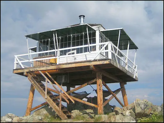
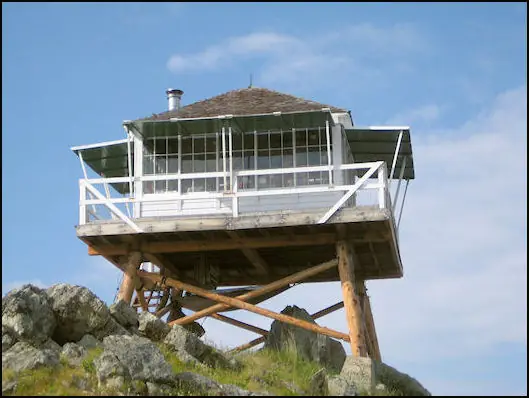
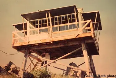
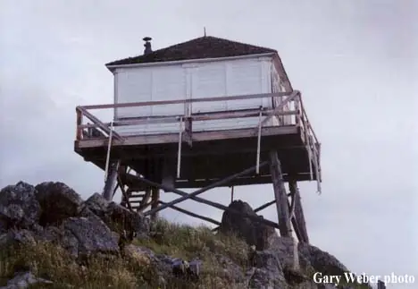
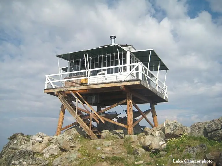
A 1939 L-4 cab on a short tower in the Bitterroot National Forest, abandoned for nearly two decades, restored in the early 2000s and now a reservable Forest Service rental.
- Standing
- Rentable
- Open to the public
- Verified
Visit & stay
You can rent this lookout for overnight stays through recreation.gov.
- Sleeps
- Up to 4 people
- Getting there
- The lookout can be accessed by vehicle and then a short hike over a moderate grade for the remainder of the route.
Rules
- Pack out all trash
- No smoking
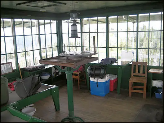
Overview The Gird Point Lookout offers a unique chance to camp on top of a mountain peak in a rustic, old-time setting. It sits high above the valley and provides panoramic views of three surrounding mountain ranges. Comfortably equipped, the lookout tower provides almost everything anyone would need to enjoy a variety of recreational opportunities available in the mountains of western Montana. Recreation A variety of hiking and mountain biking trails are available in the area, as well as some off-road vehicle trails. The adjacent mountainsides have had several large fires in the last few decades and visitors will see a mosaic of recovering vegetation patterns. Hazardous snags still remain standing and hikers should use caution, especially during high winds. The lookout is known for its scenic views that can be enjoyed on just about any day of the year, regardless of current weather conditions. It provides a peaceful location to relax and enjoy nature. A variety of wildlife make its home in the area as well, providing ample sightseeing and wildlife viewing opportunities, from a vantage point at least 8 feet from the highest point in the region. Facilities The 14-by-14 lookout is equipped with two beds that can sleep up to four people. It has a table and chairs, a propane stove and lantern, basic eating and cooking utensils and pots and pans, as well as a wood stove for heat and cooking. Firewood should be available at the tower but supply cannot be guaranteed. An outdoor toilet is also provided. Guests will need to bring their own water for drinking, cooking and cleaning purposes, as well as propane fuel canisters. Bedding, including mattress pads, is not provided. Visitors should plan to bring bedding, towels, soap, matches, garbage bags, toilet paper and food, among other necessities. Guests are required to pack out all trash and clean the cabin prior to leaving. Basic cleaning equipment is provided. No smoking or open flames (candles) in the Lookout. No fireworks. The lookout can be accessed by vehicle and then a short hike over a moderate grade for the remainder of the route. Guests are responsible for their own travel arrangements and safety. The historic L-4 cabin sits on top of an 8' high tower, with narrow steps and catwalk. This may pose a hazard for children and pets. Guests are responsible for their own safety. Natural Features The lookout is located 20 miles east of Hamilton, Montana, in the Bitterroot National Forest at an elevation of 7,702 feet. A 30-inch catwalk surrounding the glass-paneled room offers unobstructed views of the surrounding Sapphire, Bitterroot and Anaconda-Pintler mountain ranges. The 8-foot tower was originally built to watch for forest fires in the Hamilton/Skalkaho area, but it was later turned into a public recreation location. The lookout was restored beginning in 2001 and now has vintage 1940s furnishings. Nearby Attractions Highway 38 is also called the Skalkaho Highway. It continues into the Sapphire Mountains along a primitive and once widely used Native American trail. The scenic drive, which is closed during winter, was built to provide access between mining areas and agricultural communities in the Bitterroot Valley.
Book on recreation.gov (opens recreation.gov)
Rental details from recreation.gov, checked 19 Oct 2026. Rules, fees and seasons change, so confirm on the booking page before you go. Data source: ridb.recreation.gov
Access
Open to the public. Booked on Recreation.gov, open mid-June to mid-September at $30 per night. Drive most of the way, then walk a moderate trail. No electricity or water.
- Can you climb it?
- Yes
- Road to the top?
- No, you have to hike
- Trail
- Drive to the trailhead on FS 714, then walk a moderate trail of roughly half a mile to three-quarters of a mile. Narrow steps and a catwalk lead to the cab.
- Staffing
- Unknown
Facts
- Status
- Type
- Cab on a tower1931-pattern L-4 lookout cab, 14 by 14 ft, on a short log towerThe design: L-4
- Built of
- Wood
- Built
- 1939
- Height
- 10 ft (3.0 m)
- Elevation
- 7,595 ft (2,315 m)
- Agency
- U.S. Forest Service, Bitterroot National Forest
- Land
- Federal land
- Location
- Ravalli County, Montana
- Coordinates
- 46.20750, −113.91056
- Registers
- This entry
- VerifiedResearched, then checked independently. Updated 19 Oct 2026.
- Firefinder id
us-mt-gird-point
View from the cab
What you see from the cab: every ridge out to about 93 miles, the named peaks in sight, and other fire lookouts within view, worked out from terrain data in your browser.
Downloads about 3.9 MB of terrain data the first time.
Or see what it could see on the map: the ground in its line of sight.
History
Then and now
- 1939 BuiltConstructed in 1939 and added to the forest's fixed-point fire detection system that yearSource: npgallery.nps.gov
- No record between 1939 and 1967
- 1967 StaffedOne of sixteen lookouts manned on the Bitterroot National Forest in 1967Source: npgallery.nps.gov
- No record between 1967 and 1984
- 1984 EventSlated for removal with seven other inactive lookouts; three of that group were saved and restoredSource: nhlr.org
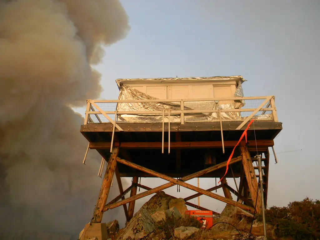
- 1990 Fire1990 Gird Point wildfire killed most subalpine fir below the lookout; firelookout.com says the fire surrounded the towerSources: npgallery.nps.gov, firelookout.com
- 2003 Added to the National Historic Lookout RegisterRegistered January 8, 2003 as US 459, MT 35Source: nhlr.org
- 2003 RestoredRestoration began in 2003 after nearly two decades abandoned; NHLR dates rehabilitation to 2002Sources: npgallery.nps.gov, nhlr.org
- TodayStandingIt still stands, as far as our sources know.
Old maps of this spot
USGS topographic maps from the years a lookout stood may show it, often as a small symbol labelled “Lookout”. See the old topo maps around it on the Firefinder map, or find every scanned sheet of this spot on USGS TopoView (opens another site) (click the spot there to list them, with dates and downloads).
Story
Researched 8 Oct 2026, fact-checked.
Gird Point Lookout sits at 7,702 feet in the Sapphire Mountains of the Bitterroot National Forest, about 11 miles east of Hamilton, Montana.1,2
The forest put the lookout on its fixed-point fire detection network in 1939, the year it was built.1 The National Register nomination says it was probably built with Civilian Conservation Corps labor.1 The cab is a 1931-pattern L-4 design, 14 feet square.1,3 Sources disagree on the height of its tower. The nomination and firelookout.com say 10 feet, while the Forest Service page and the NHLR say 8.1,4,2,5
The nomination counts it among the sixteen Bitterroot lookouts staffed in 1967.1 A staff list on firelookout.com runs from 1958 to 1971, and the site says the tower was staffed into the 1980s.4
In 1984 the NHLR says Gird Point and seven other inactive lookouts were slated for removal, and that three of them were saved and restored.5 The nomination says the 1990 Gird Point wildfire killed most of the stands of subalpine fir that once grew on the slopes below the tower.1 Firelookout.com says the fire surrounded the lookout that year.4
The nomination says the lookout was abandoned for nearly two decades before restoration began in 2003. The restoration swapped the log tower legs for like-for-like replacements and rebuilt the catwalk.1 The NHLR dates the rehabilitation to 2002, so the two sources differ by a year.5 The nomination calls the lookout eligible for National Register listing under criteria A and C, and says it is now a cabin rental.1
The Forest Service rents the cabin. Reservations open from mid-June through mid-September on Recreation.gov, at $30 a night.2 There is no electricity or water, so guests bring their own supplies.2,3 Visitors drive most of the way and then walk a moderate trail. The Forest Service page gives that walk as a half-mile in one place and about three-quarters of a mile in another.2 The Forest Service describes narrow steps and a catwalk on the 8-foot tower, and notes that the lookout may be hazardous for children and pets.2
- Gird Point Lookout, National Register of Historic Places nomination (NRIS 100002297), National Park Service, https://npgallery.nps.gov/GetAsset/3190ba92-c994-4b58-9c49-47298cb954aa (accessed 2026-10-08). ↩
- Gird Point Lookout, Bitterroot National Forest, U.S. Forest Service, https://www.fs.usda.gov/r01/bitterroot/recreation/gird-point-lookout (accessed 2026-10-08). ↩
- Gird Point, Bitterroot National Forest, Recreation.gov, https://www.recreation.gov/camping/campgrounds/234281 (accessed 2026-10-08). ↩
- Gird Point Fire Lookout Tower, firelookout.com, https://www.firelookout.com/mt/girdpt.html (accessed 2026-10-08). ↩
- Gird Point Lookout, National Historic Lookout Register, http://nhlr.org/lookouts/us/mt/gird-point-lookout/ (accessed 2026-10-08). ↩
Photos

Photos keep their own rights and are shown with credit. Is one of these yours? You can ask for a different credit or for removal.
Sources
- National Historic Lookout Register (NHLR) (opens another site) Gave us: name, location, county, elevation, register numbers, agency, dates, photos, links National Historic Lookout Register (nhlr.org) · All rights reserved (American Resources, Inc.); facts extracted only, no prose copied. · retrieved 4 Oct 2026
- Forest Fire Lookout Association (FFLA) - US lookout lists (opens another site) Gave us: type, status, register numbers, links Forest Fire Lookout Association (firelookout.org) · No licence stated; facts extracted only, no prose copied. · retrieved 8 Oct 2026
- Recreation Information Database (recreation.gov) (opens another site) Gave us: ownership, access, rental details, links Data source: ridb.recreation.gov · Public data from the US government · retrieved 19 Oct 2026
- Forest Fire Lookout Association: lookout rentals (opens another site) Gave us: rental details, links Forest Fire Lookout Association rentals list (firelookout.org) · No licence stated; facts extracted only (state, name, booking link, manager, closure note), no prose copied. The FFLA says it is not involved in managing any rental program. · retrieved 19 Oct 2026
- firelookout.com -- Rex Kamstra's Forest Fire Lookout Page (opens another site) Gave us: what it is built of, design, height, dates, photos, links firelookout.com · No licence stated on the site; facts only (coordinates, elevation, built/destroyed years, design, agency). Photos mirrored with the site's stated credit. · retrieved 4 Oct 2026
- Wikidata -- US fire lookout towers (Q748998 and subclasses) (opens another site) Gave us: register numbers, photos, links Wikidata · CC0 1.0 (Wikidata). Images keep their own Commons licence/credit. · retrieved 4 Oct 2026
- FOREST LOOKOUTS -- western US (Ron Kemnow's weebly sites) (opens another site) Gave us: links Ron Kemnow's Forest Lookouts sites (westlookouts, californialookouts, idaholookouts, montanalookouts, oregonlookouts and washingtonlookouts .weebly.com) · No licence stated; facts only (county, land manager, status word, coordinates where the page's own map widget gives them, township-range-section, height and design hints, links). The site's own newspaper quotes, citations and narrative are not reproduced. · retrieved 8 Oct 2026
- Firefinder research Gave us: summary, design, height, status, agency, access, visiting details, dates, links, fact-check Firefinder research (sources cited in the story footnotes) · Our own research notes; each fact cites its source in the lookout's story
More about this lookout elsewhere
- NHLR register entry US 459 (nhlr.org) (opens another site)
- Recreation.gov listing (opens another site)
- Gird Point Lookout, National Register of Historic Places nomination (NRIS 100002297) (National Park Service, NPGallery) (opens another site)
- Gird Point Lookout (U.S. Forest Service, Bitterroot National Forest) (opens another site)
- FFLA Montana lookout list (firelookout.org) (opens another site)
- FFLA lookout rentals list (firelookout.org) (opens another site)
- Gird Point on firelookout.com (Rex Kamstra) (opens another site)
- Gird Point on Forest Lookouts, western US (Ron Kemnow) (opens another site)
- Wikidata item Q86868161 (opens another site)
Firefinder takes facts (places, dates, numbers) from these sources and writes its own words. See all sources and licences.