Fire lookout · Silver Bow County, Montana
Highland (Red) Lookout
Also known as Highland (Red Mountain), Highland Lookout, Highland Mountain (Red)
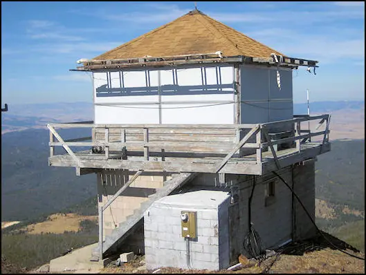
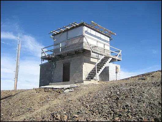
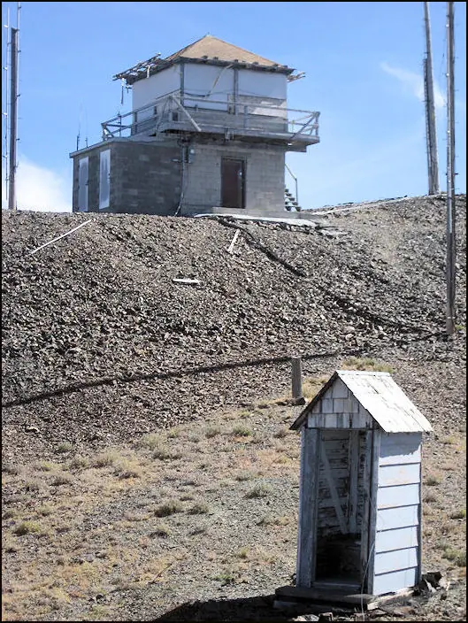
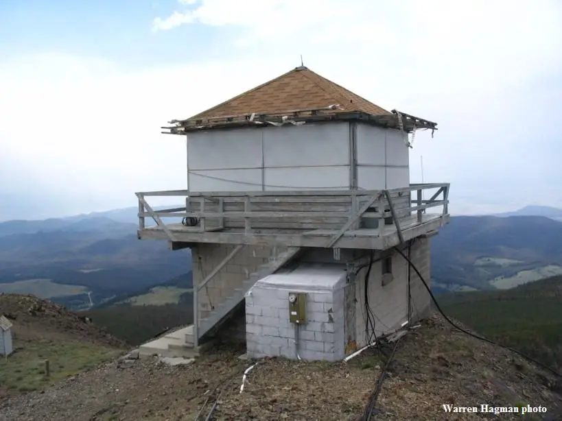
Highland (Red) Lookout on Red Mountain south of Butte: a site developed about 1933, a present L-4 cab built in 1954, now listed as available for emergencies.
- Standing
- Restricted access
- Verified
Visit & stay
Not rentable. As far as we know, this lookout cannot be booked for overnight stays.
Access
Restricted access
Access is seasonal, gated or needs a permit. Check before you go. Listed as available for emergencies; no public rental or visitor program found. Reached by an unpaved, seasonal summit road.
- Can you climb it?
- Unknown
- Road to the top?
- Yes, you can drive up
- Trail
- Fish Creek Road is unpaved, needs a high-clearance 4x4, and is usually impassable October to June. With no snow and enough clearance, a four-wheel-drive trail runs to a gate just over 9,000 ft.
- Staffing
- Unknown
Facts
- Status
- Type
- Two-story buildingL-4The design: L-4
- Built of
- WoodGoing by its design; no source says so in words.
- Built
- 1933
- Height
- Unknown
- Elevation
- 9,701 ft (2,957 m)
- Agency
- U.S. Forest Service
- Land
- Federal land
- Location
- Silver Bow County, Montana
- Coordinates
- 45.76864, −112.48512
- Registers
- This entry
- VerifiedResearched, then checked independently. Updated 8 Oct 2026.
- Firefinder id
us-mt-highland-red
View from the cab
What you see from the cab: every ridge out to about 93 miles, the named peaks in sight, and other fire lookouts within view, worked out from terrain data in your browser.
Downloads about 3.9 MB of terrain data the first time.
Or see what it could see on the map: the ground in its line of sight.
History
Then and now
- 1922 EventLightning strike on August 22, 1922, on a group of Butte Boy Scouts during a hike. One scout died and others were injured.Source: dangerousroads.org
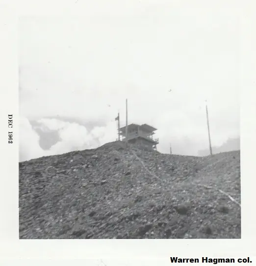
- 1933 BuiltFirst L-4 structure on the site. firelookout.com says an L-4 cab on the summit; NHLR calls it an L-4 groundhouse.Sources: nhlr.org, firelookout.com
- No record between 1933 and 1954
- 1954 Built'Built' field on NHLR detail pageSource: NHLR register entry
- 1954 Replaced by a new structurePresent L-4 cab on a concrete base replaced the 1933 structure. firelookout.com places it about 1/4 mile north of Red Mtn.Sources: nhlr.org, firelookout.com, dangerousroads.org
- No record between 1954 and 2011
- 2011 Added to the National Historic Lookout RegisterRegistered as NHLR US 927 (MT 55) on September 24, 2011.Source: nhlr.org
- 2022 EventMemorial monument installed beside the tower to the 1922 lightning strike.Source: dangerousroads.org
- TodayStandingIt still stands, as far as our sources know.
Old maps of this spot
USGS topographic maps from the years a lookout stood may show it, often as a small symbol labelled “Lookout”. See the old topo maps around it on the Firefinder map, or find every scanned sheet of this spot on USGS TopoView (opens another site) (click the spot there to list them, with dates and downloads).
Story
Researched 8 Oct 2026, fact-checked.
Red Mountain, also called Devil's Peak, rises south of Butte inside the Beaverhead-Deerlodge National Forest.1 The lookout there was first developed around 1933, and an L-4 cab stood on the summit.2 The cab standing today went up in 1954 on a concrete base, about a quarter mile north of the peak, according to firelookout.com.3,2
Sources disagree about what came before and where the newer cab sits. The National Historic Lookout Register says the 1954 cab succeeded an L-4 groundhouse put up in 1933.3 A travel guide places the 1954 tower at the summit and says it replaced that same groundhouse.1 The firelookout.com listing puts the newer cab a quarter mile north and says the earlier cab stood on the summit.2
According to the register, the present building is an L-4 cab with a catwalk, sitting on a single-story concrete base.3
One event stands out in the sources. On August 22, 1922, a lightning bolt struck a group of Boy Scouts from Butte during a hike. One scout died and others were hurt.1 A monument beside the tower, installed in 2022, marks that day.1
The firelookout.com listing says the cab is still there and available for emergencies.2 Getting there means driving Fish Creek Road, which is totally unpaved and needs a 4x4 with high clearance.1 The road is not plowed, and vehicles usually cannot get through from October to June.1 When there is no snow and the car has enough clearance, a four-wheel-drive trail runs up to a gate just over 9,000 feet.4 Snow can close two gates on the road to the campground in winter.4 The tower stands below the peak, and a road leads to it.4
Because the listing says it is available for emergencies, and the Forest Service administers it, treat it as a Forest Service structure rather than a place to climb.3,2
- How to drive the unpaved road to Red Mountain in Montana?, DangerousRoads.org, https://www.dangerousroads.org/north-america/usa/8203-red-mountain-montana.html (accessed 2026-10-08). ↩
- Highland (Red) Mtn. Fire Lookout Tower, Firelookout.com, https://www.firelookout.com/mt/highland.html (accessed 2026-10-08). ↩
- Highland (Red) Lookout, National Historic Lookout Register, http://nhlr.org/lookouts/us/mt/highland-red-lookout/ (accessed 2026-10-08). ↩
- Red Mountain, SummitPost, https://www.summitpost.org/red-mountain/153185 (accessed 2026-10-08). ↩
Photos
Photos keep their own rights and are shown with credit. Is one of these yours? You can ask for a different credit or for removal.
Sources
- National Historic Lookout Register (NHLR) (opens another site) Gave us: name, location, county, elevation, register numbers, agency, ownership, dates, photos, links National Historic Lookout Register (nhlr.org) · All rights reserved (American Resources, Inc.); facts extracted only, no prose copied. · retrieved 4 Oct 2026
- Forest Fire Lookout Association (FFLA) - US lookout lists (opens another site) Gave us: type, status, register numbers, links Forest Fire Lookout Association (firelookout.org) · No licence stated; facts extracted only, no prose copied. · retrieved 8 Oct 2026
- firelookout.com -- Rex Kamstra's Forest Fire Lookout Page (opens another site) Gave us: what it is built of, design, photos, links firelookout.com · No licence stated on the site; facts only (coordinates, elevation, built/destroyed years, design, agency). Photos mirrored with the site's stated credit. · retrieved 4 Oct 2026
- OpenStreetMap -- fire lookout structures (opens another site) Gave us: links © OpenStreetMap contributors · ODbL 1.0. (c) OpenStreetMap contributors. · retrieved 4 Oct 2026
- FOREST LOOKOUTS -- western US (Ron Kemnow's weebly sites) (opens another site) Gave us: links Ron Kemnow's Forest Lookouts sites (westlookouts, californialookouts, idaholookouts, montanalookouts, oregonlookouts and washingtonlookouts .weebly.com) · No licence stated; facts only (county, land manager, status word, coordinates where the page's own map widget gives them, township-range-section, height and design hints, links). The site's own newspaper quotes, citations and narrative are not reproduced. · retrieved 8 Oct 2026
- Firefinder research Gave us: summary, design, status, agency, access, staffing, visiting details, dates, links, fact-check Firefinder research (sources cited in the story footnotes) · Our own research notes; each fact cites its source in the lookout's story
More about this lookout elsewhere
- NHLR register entry US 927 (nhlr.org) (opens another site)
- NHLR register entry (nhlr.org) (opens another site)
- How to drive the unpaved road to Red Mountain in Montana? (DangerousRoads.org) (opens another site)
- Red Mountain (SummitPost) (opens another site)
- FFLA Montana lookout list (firelookout.org) (opens another site)
- Highland (Red) Mtn. on firelookout.com (Rex Kamstra) (opens another site)
- Highland Mountain (Red) on Forest Lookouts, western US (Ron Kemnow) (opens another site)
- OpenStreetMap node 45996619 (opens another site)
Firefinder takes facts (places, dates, numbers) from these sources and writes its own words. See all sources and licences.