Fire lookout · Ravalli County, Montana
McCart Lookout
Also known as McCart Ridge
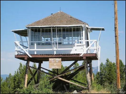
An L-4 lookout built in 1939 on McCart Peak in the Bitterroot National Forest, retired from fire duty in 1984, restored in 1991-92, and now a popular trail-in rental cabin.
- Standing
- Rentable
- Open to the public
- Verified
Visit & stay
You can rent this lookout for overnight stays through recreation.gov.
- Fee
- The lookout can be reserved up to 180 days in advance. Changes in scheduled reservation dates may be assessed an additional fees by Recreation.gov.
- Getting there
- Do not leave anything you bring, even if you think it will benefit other renters The tower is accessed by a moderate, 1.5-mile hike from the parking area.
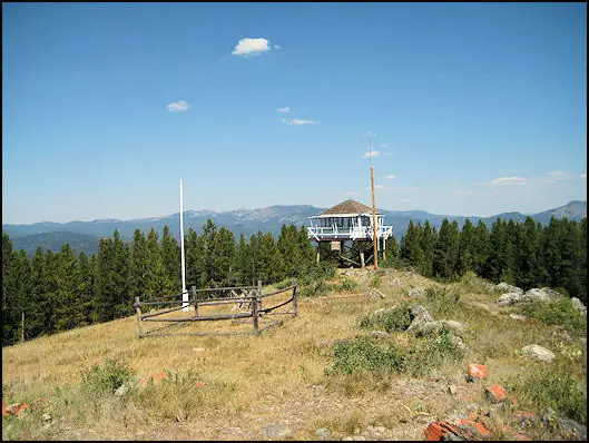
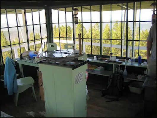
Overview McCart Lookout is a historic tower located on McCart Peak, east of Sula. It has been restored to reflect a lookout of the 1940s, including the stove, furniture, dishes and other small touches. It offers a unique chance for visitors to camp on a mountain peak, on the border of the Anaconda-Pintler Wilderness, in a rustic, old-time setting. The tower provides spectacular views of the surrounding western Montana wilderness. Recreation The trail to reach the tower continues south and joins the Continental Divide National Scenic Trail, which extends 3,100 miles across the United States, from the borders of Mexico to Canada. While it might take about six months to complete, a variety of day hikes and points of exploration are available within the area of the lookout tower. Trails can be enjoyed on foot or on horseback. Backpackers also enjoy the terrain. Aside from hiking and horseback riding, the area is replete with wildlife and offers scenic views. A lookout journal is kept inside, providing instructions of what to do in case of emergency or a storm. Danger from lightning is largely abated due to a lightning rod implanted at the structure. Facilities McCart Lookout is a historic "L4" lookout located on Mccart Peak east of the Bitterroot Valley. The lookout is a one room cabin with a bed platform suitable for two people. Bedding is not provided. The lookout can accommodate up to four. Others are welcome to tent camp in the area. The lookout measures 14ft.X14ft. with a 30 inch catwalk around the outside. There is a wood stove for heat. You may have to saw your own wood from dead and down material found nearby. A bow saw and ax are provided. A two burner propane camp stove and lanterns are provided. Propane is not provided, you will need to bring your own propane canisters. Utensils for cooking and eating are provided. There is no water available near the lookout so please bring your own water. An outdoor toilet serves the lookout. You will need to provide your own toilet paper. The lookout is built on a 10 foot tall tower, with narrow steps and catwalk. This may pose a hazard for children and pets. Guests are responsible for their own safety. Remember, guests will need to bring their own water for drinking, cooking and cleaning purposes, as well as propane fuel canisters for cooking and lighting. Guests are also responsible for their own bedding, towels, soap, toilet paper and garbage bags. The facility does not provide trash receptacles; all garbage must be carried out, and the tower must be cleaned by guests prior to leaving. Do not leave anything you bring, even if you think it will benefit other renters The tower is accessed by a moderate, 1.5-mile hike from the parking area. Snowmobiles and other off-road vehicles are not allowed on the trail, however, horses and other livestock are welcome. Guests are responsible for their own travel arrangements and safety, and must bring several of their own amenities. Natural Features The tower is situated east of the Bitterroot Valley, at an elevation of 7,115 feet. It was named for William McCart, who settled the area but failed to complete his homestead entry to patent. It is poised on the edge of the Anaconda-Pintler Wilderness and offers beautiful views of the Pintler Mountains to the east and the Bitterroot Mountains to the west. The Bitterroot forest is home to many species of wildlife, from mule deer, whitetail deer, elk, bighorn sheep, mountain goats, black bear, mountain lions, and moose, to many varieties of smaller animals and birds. Nearby Attractions A variety of natural hot springs exist in the area, including the the Lost Trail Hot Springs, which is located about 13 miles northwest of the tower. It provides swimming and additional amenities, including a general store and lodging.
Book on recreation.gov (opens recreation.gov)
Rental details from recreation.gov, checked 19 Oct 2026. Rules, fees and seasons change, so confirm on the booking page before you go. Data source: ridb.recreation.gov
Access
Open to the public. Reached only by a moderate 1.5-mile trail; no vehicle access; Forest Service rental cabin
- Can you climb it?
- Yes
- Road to the top?
- No, you have to hike
- Trail
- 1.5-mile hike from the parking area; no snowmobiles, ATVs, or motorcycles on the trail
- Staffing
- Unknown
Facts
- Status
- Type
- Cab on a towerL-4, 14x14 ft live-in cab with catwalk on a low wooden tower (~10 ft)The design: L-4
- Built of
- Wood
- Built
- 1939
- Height
- 10 ft (3.0 m)
- Elevation
- 7,185 ft (2,190 m)
- Agency
- U.S. Forest Service
- Land
- Federal land
- Location
- Ravalli County, Montana
- Coordinates
- 45.88478, −113.71748 sources disagree
- Registers
- This entry
- VerifiedResearched, then checked independently. Updated 19 Oct 2026.
- Firefinder id
us-mt-mccart
View from the cab
What you see from the cab: every ridge out to about 93 miles, the named peaks in sight, and other fire lookouts within view, worked out from terrain data in your browser.
Downloads about 3.9 MB of terrain data the first time.
Or see what it could see on the map: the ground in its line of sight.
History
Then and now
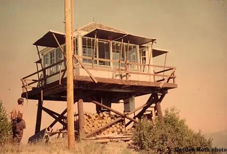
- 1939 BuiltBuilt by the U.S. Forest Service; engineer Clyde FickesSources: nhlr.org, en.wikipedia.org
- No record between 1939 and 1984
- 1984 EventRetired from fire detection use, replaced by TeePee Lookout to the northSource: nhlr.org
- 1991 RestoredCompletely restored 1991-92 by the Sula Ranger District, refitted to a 1940s appearanceSources: nhlr.org, recreation.gov
- 1993 Opened as a rentalPlaced into the cabin rental program in 1993Source: nhlr.org
- 1994 Added to the National Historic Lookout RegisterRegistered on the National Historic Lookout Register, May 1, 1994Source: nhlr.org
- 1996 Listed on the National Register of Historic PlacesAdded to the National Register of Historic Places, June 19, 1996Source: en.wikipedia.org
- TodayStandingIt still stands, as far as our sources know.
Old maps of this spot
USGS topographic maps from the years a lookout stood may show it, often as a small symbol labelled “Lookout”. See the old topo maps around it on the Firefinder map, or find every scanned sheet of this spot on USGS TopoView (opens another site) (click the spot there to list them, with dates and downloads).
Story
Researched 4 Oct 2026, fact-checked.
McCart Lookout stands on McCart Peak in the Bitterroot National Forest, east of Sula, Montana, on the edge of the Anaconda-Pintler Wilderness.1,2 The Forest Service built it in 1939 to an L-4 design: a 14-by-14-foot live-in cab with a catwalk, set on a low wooden tower about 10 feet tall.3,2 It was engineered by Clyde Fickes and named for Bill McCart, a longtime Forest Service employee in what was then the East Fork District, now the Sula Ranger District.1
The lookout served its intended purpose — fire detection — until 1984, when it was taken out of service and replaced by TeePee Lookout to the north.3 After sitting unused for several years, the Sula Ranger District gave it a complete restoration in 1991-92, refitting it to reflect how a lookout would have looked in the 1940s, down to the stove, furniture, and dishes.3,2 In 1993 it was placed into the Forest Service's cabin rental program, and it has reportedly become a popular overnight destination for hikers ever since.3
McCart Lookout was listed on the National Register of Historic Places on June 19, 1996.1 It sits at roughly 7,100 feet elevation.1
Today the lookout is reached only by trail — a moderate 1.5-mile hike from the parking area — and is not accessible by vehicle, snowmobile, or other off-road vehicle, though horses and other livestock are permitted on the path.2 Inside, it sleeps up to two people on a bed platform (with room for up to four total), has a wood stove for heat, a two-burner propane camp stove, and basic cooking utensils, but no running water; guests bring their own water, propane, and bedding and pack out all trash.2 The narrow stairs and catwalk sit about 10 feet off the ground, which the rental listing flags as a hazard for children and pets.2 It remains a working rental cabin managed through Recreation.gov.2
- McCart Fire Lookout, Wikipedia, https://en.wikipedia.org/wiki/McCart_Fire_Lookout (accessed 2026-10-04). ↩
- McCart Lookout, Recreation.gov, https://www.recreation.gov/camping/campgrounds/234292 (accessed 2026-10-04). ↩
- McCart Lookout, National Historic Lookout Register (nhlr.org), http://nhlr.org/lookouts/us/mt/mccart-lookout/ (accessed 2026-10-04). ↩
Photos
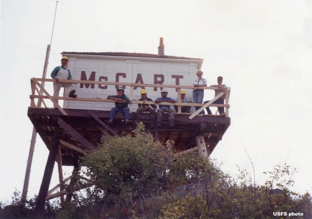
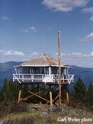
Photos keep their own rights and are shown with credit. Is one of these yours? You can ask for a different credit or for removal.
Where sources disagree
We show disagreements between sources instead of quietly picking one. If you know which is right, please tell us.
Sources disagree on the location by 620 m.
- FFLA: 45.88478, −113.71748
- NHLR: 45.87980, −113.71381
They share a register number.
The map uses the position from FFLA.
Sources
- National Historic Lookout Register (NHLR) (opens another site) Gave us: name, county, elevation, what it is built of, register numbers, agency, dates, photos, links National Historic Lookout Register (nhlr.org) · All rights reserved (American Resources, Inc.); facts extracted only, no prose copied. · retrieved 4 Oct 2026
- Forest Fire Lookout Association (FFLA) - US lookout lists (opens another site) Gave us: location, type, status, register numbers, links Forest Fire Lookout Association (firelookout.org) · No licence stated; facts extracted only, no prose copied. · retrieved 8 Oct 2026
- Recreation Information Database (recreation.gov) (opens another site) Gave us: ownership, access, rental details, links Data source: ridb.recreation.gov · Public data from the US government · retrieved 19 Oct 2026
- Forest Fire Lookout Association: lookout rentals (opens another site) Gave us: rental details, links Forest Fire Lookout Association rentals list (firelookout.org) · No licence stated; facts extracted only (state, name, booking link, manager, closure note), no prose copied. The FFLA says it is not involved in managing any rental program. · retrieved 19 Oct 2026
- firelookout.com -- Rex Kamstra's Forest Fire Lookout Page (opens another site) Gave us: design, height, dates, photos, links firelookout.com · No licence stated on the site; facts only (coordinates, elevation, built/destroyed years, design, agency). Photos mirrored with the site's stated credit. · retrieved 4 Oct 2026
- Wikidata -- US fire lookout towers (Q748998 and subclasses) (opens another site) Gave us: register numbers, links Wikidata · CC0 1.0 (Wikidata). Images keep their own Commons licence/credit. · retrieved 4 Oct 2026
- OpenStreetMap -- fire lookout structures (opens another site) Gave us: links © OpenStreetMap contributors · ODbL 1.0. (c) OpenStreetMap contributors. · retrieved 4 Oct 2026
- FOREST LOOKOUTS -- western US (Ron Kemnow's weebly sites) (opens another site) Gave us: links Ron Kemnow's Forest Lookouts sites (westlookouts, californialookouts, idaholookouts, montanalookouts, oregonlookouts and washingtonlookouts .weebly.com) · No licence stated; facts only (county, land manager, status word, coordinates where the page's own map widget gives them, township-range-section, height and design hints, links). The site's own newspaper quotes, citations and narrative are not reproduced. · retrieved 8 Oct 2026
- Firefinder research Gave us: summary, design, height, status, agency, access, visiting details, dates, links, fact-check Firefinder research (sources cited in the story footnotes) · Our own research notes; each fact cites its source in the lookout's story
More about this lookout elsewhere
- NHLR register entry US 85 (nhlr.org) (opens another site)
- Recreation.gov listing (opens another site)
- FFLA Montana lookout list (firelookout.org) (opens another site)
- FFLA lookout rentals list (firelookout.org) (opens another site)
- Wikipedia: McCart Fire Lookout (opens another site)
- McCart Ridge on firelookout.com (Rex Kamstra) (opens another site)
- McCart on Forest Lookouts, western US (Ron Kemnow) (opens another site)
- Website (npgallery.nps.gov) (opens another site)
- Wikidata item Q85784515 (opens another site)
- OpenStreetMap way 1311578055 (opens another site)
Firefinder takes facts (places, dates, numbers) from these sources and writes its own words. See all sources and licences.