Fire lookout · Lincoln County, Montana
McGuire Mountain Lookout
Also known as McGuire
A 1923/1924 D-6 cupola lookout used as a camp from 1921, abandoned by the mid-1940s, restored starting 1982-83, and now a rentable Kootenai National Forest cabin.
- Standing
- Rentable
- Open to the public
- Verified
Visit & stay
You can rent this lookout for overnight stays through recreation.gov.
- Season
- up to four people
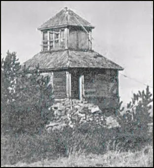
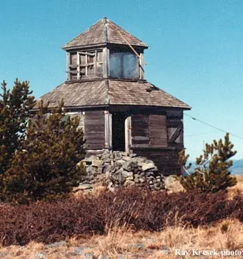
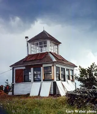
Overview McGuire Mountain Lookout was originally constructed in 1923 and was actively used as an observation point for detecting forest fires for over 20 years before it was abandoned around 1944. The structure was later renovated between 1983 and 1998 and is now available for rent for up to four people. McGuire Mountain is located approximately 14 miles southwest of Eureka. Access to the lookout requires a 2.5 mile hike from the parking area at Little Sutton Mountain; visitor arrival is dependent on road and weather conditions. Recreation Backpacking opportunities abound in the area surrounding McGuire Mountain. Take trail #446 past the lookout and enjoy many more miles of scenic views. A day trip to Koocanusa Reservoir offers visitors the option of biking, fishing, hiking or boating around the lake. Trail #90, which starts just off of the Koocanusa Reservoir on Hwy 37, follows McGuire Creek closely for a scenic hike along the water. Because the McGuire Lookout is surrounded by windows on top of one of the area's tallest summits (almost 7,000 feet), visitors have the best views of the sunrise and sunset over the surrounding cabinet mountains. Facilities The lookout is a 12 x 12 foot wood-frame cabin with a pyramidal-shaped roof. On top of the roof there is a pyramidal-shaped cupola and a wooden ladder inside the cabin leading up to it. Windows completely surround the structure, providing a 360-degree view of the surrounding area. The rustic-style cabin is not wired for electricity. The main room is equipped with a modern wood stove, 2 twin size bed boards (no mattresses), a table, a bench, a shovel, a bucket and cleaning gear. Firewood is provided, but the supply cannot be guaranteed. There is no water available at the lookout and water sources in the area are limited. There is a toilet provided outside the lookout. Guests are advised to bring plenty of their own drinking water. In addition to water, several supplies are needed to ensure a comfortable stay. Sleeping bags and pads, cooking equipment, toilet paper, lanterns, food supplies and matches are recommended. Natural Features The McGuire Mountain Lookout is located in the Rexford Ranger district within the Koocanusa Area, which is primarily centered along the narrow 90-mile Koocanusa Reservoir, formed by the Libby Dam. The Koocanusa Reservoir is the major recreation attraction in the area and contains a large and stable population of Kookanee salmon, Kamloops (rainbow) trout, bull trout, West slope cutthroat trout and burbot. The Koocanusa Area is the perfect setting for year round recreational attractions, including: fishing, water sports, rock and ice climbing, and driving for pleasure, especially during the fall Western Larch color change. Nearby Attractions Two paved highways running adjacent to the reservoir and extending from Eureka to Libby have been designated by the Forest Service as a Scenic Byway. Traffic is light and views along the roadways are memorable, including glimpses of the Ural-Tweed Big Horn Sheep herd, located on the eastern side of the reservoir along Hwy 37.
Book on recreation.gov (opens recreation.gov)
Rental details from recreation.gov, checked 19 Oct 2026. Rules, fees and seasons change, so confirm on the booking page before you go. Data source: ridb.recreation.gov
Access
Open to the public. Reached by a 2.5-mile hike from Little Sutton Mountain trailhead; rented through Recreation.gov
- Can you climb it?
- No
- Road to the top?
- No, you have to hike
- Trail
- 2.5-mile hike from the parking area at Little Sutton Mountain
- Staffing
- Unknown
Facts
- Status
- Type
- Ground-level cabD-6 cupola cab, 12x12-ft wood frame with pyramidal roof and windowed cupolaThe design: D-6
- Built of
- WoodGoing by its design; no source says so in words.
- Built
- 1923
- Height
- Unknown
- Elevation
- 6,942 ft (2,116 m)
- Agency
- U.S. Forest Service, Kootenai National Forest (Rexford Ranger District)
- Land
- Federal land
- Location
- Lincoln County, Montana
- Coordinates
- 48.68310, −115.20233 sources disagree
- Registers
- This entry
- VerifiedResearched, then checked independently. Updated 19 Oct 2026.
- Firefinder id
us-mt-mcguire-mountain
View from the cab
What you see from the cab: every ridge out to about 93 miles, the named peaks in sight, and other fire lookouts within view, worked out from terrain data in your browser.
Downloads about 4.3 MB of terrain data the first time.
Or see what it could see on the map: the ground in its line of sight.
History
Then and now
- 1921 EventFirst used as an unstructured camp lookoutSource: firelookout.com
- 1923 BuiltRecreation.gov gives 1923 as the construction year, conflicting with the 1924 date on NHLR/firelookout.comSource: recreation.gov
- 1924 BuiltD-6 cupola cab constructed; NHLR and firelookout.com both give 1924Sources: nhlr.org, firelookout.com
- No record between 1924 and 1944
- 1944 AbandonedRecreation.gov: abandoned around 1944 after over 20 years of active fire-detection useSource: recreation.gov
- 1947 AbandonedNHLR: abandoned for 35 years before the 1982 restoration, implying abandonment around 1947Source: nhlr.org
- No record between 1947 and 1982
- 1982 RestoredNHLR and firelookout.com date the restoration to 1982 (NHLR) or 1983 (firelookout.com)Sources: nhlr.org, firelookout.com
- No record between 1982 and 1998
- 1998 RestoredRecreation.gov describes renovation spanning 1983 to 1998Source: recreation.gov
- 2000 Added to the National Historic Lookout RegisterRegistered on the National Historic Lookout Register, May 12, 2000, as US 345Source: nhlr.org
- No record between 2000 and 2016
- 2016 Condition assessmentFirst on-site condition assessment, the start of the long restoration project.Sources: nwmt-ffla.org, nwmt-ffla.org
- 2020 Condition assessmentIn-depth assessment to prepare the next summer's restoration.Sources: nwmt-ffla.org, nwmt-ffla.org
- 2021 RestoredWindows reglazed off-site at Murphy Lake Ranger Station, building squared and levelled, siding and trim repaired, painted inside and out, new shutters.Sources: nwmt-ffla.org, nwmt-ffla.org
- 2022 RestoredWith the rental closed for a week, final touches on the shutters for the cabin and cupola windows; outhouse pit started.Sources: nwmt-ffla.org, nwmt-ffla.org
- 2023 RestoredOuthouse moved onto a new vault and the lookout and both support structures re-roofed, completing the project.Sources: nwmt-ffla.org, nwmt-ffla.org
- 2024 RestoredStorage shed repaired and painted and a summer shutter-storage cover built, in the lookout's 100th year.Sources: nwmt-ffla.org, nwmt-ffla.org
- 2026 RestoredCupola shutters converted back to the original hinged system, spot painting and ventilation screens.Source: nwmt-ffla.org
- TodayStandingIt still stands, as far as our sources know.
Old maps of this spot
USGS topographic maps from the years a lookout stood may show it, often as a small symbol labelled “Lookout”. See the old topo maps around it on the Firefinder map, or find every scanned sheet of this spot on USGS TopoView (opens another site) (click the spot there to list them, with dates and downloads).
Story
Researched 4 Oct 2026, fact-checked.
McGuire Mountain's lookout started as a simple camp site, used from 1921, before a permanent cabin went up. Sources disagree on exactly when: the National Historic Lookout Register and firelookout.com date the cab to 1924, while the Forest Service's own Recreation.gov listing for the site says 1923.1,2,3 It is a D-6 cupola design, a style common for its era, built with a pyramidal roof topped by a small windowed cupola reached by a wooden ladder inside the cabin.1,2,3 The D-6 design was eventually superseded by the better-known L-4 cab, and only two or three D-6 lookouts are reported still in fire service anywhere in the country.1
The lookout was staffed to watch for smoke for a couple of decades. The National Historic Lookout Register says it sat abandoned for 35 years before its 1982 restoration, which would put abandonment around 1947; Recreation.gov instead says the lookout was abandoned around 1944, after more than 20 years of active use.1,2 Either way, by the mid-1940s the cabin had gone out of service and sat empty for decades, on land now administered as part of the Kootenai National Forest.
Restoration eventually returned the cabin to use. The National Historic Lookout Register and firelookout.com both point to a 1982-83 restoration, while Recreation.gov describes a longer renovation stretching from 1983 to 1998; after that work it was placed into the Forest Service's recreation rental program.1,2,3 It was added to the National Historic Lookout Register in 2000 as US 345.1
Today the 12-by-12-foot wood-frame cabin, windowed on all sides, sits about 14 miles southwest of Eureka, Montana, near the Koocanusa Reservoir, and is reached by a 2.5-mile hike from a trailhead at Little Sutton Mountain.2 It sleeps up to four, has a wood stove but no electricity or running water, and is kept locked, with guests given the combination ahead of their stay; it is meant to be visited through a booked rental rather than climbed on a whim.2
- McGuire Mountain Lookout, National Historic Lookout Register (nhlr.org), http://nhlr.org/lookouts/us/mt/mcguire-mountain-lookout/ (accessed 2026-10-04). ↩
- Mcguire Mtn. Lookout Rental, Recreation.gov / Kootenai National Forest, https://www.recreation.gov/camping/campgrounds/234383 (accessed 2026-10-04). ↩
- McGuire Fire Lookout Cabin, firelookout.com, https://www.firelookout.com/mt/mcguire.html (accessed 2026-10-04). ↩
Photos
Photos keep their own rights and are shown with credit. Is one of these yours? You can ask for a different credit or for removal.
Where sources disagree
We show disagreements between sources instead of quietly picking one. If you know which is right, please tell us.
Sources disagree on the location by 520 m.
- NHLR: 48.68310, −115.20233
- FFLA: 48.68755, −115.20460
They share a register number.
The map uses the position from NHLR.
Sources
- National Historic Lookout Register (NHLR) (opens another site) Gave us: name, location, county, elevation, register numbers, agency, dates, photos, links National Historic Lookout Register (nhlr.org) · All rights reserved (American Resources, Inc.); facts extracted only, no prose copied. · retrieved 4 Oct 2026
- Forest Fire Lookout Association (FFLA) - US lookout lists (opens another site) Gave us: type, status, register numbers, links Forest Fire Lookout Association (firelookout.org) · No licence stated; facts extracted only, no prose copied. · retrieved 8 Oct 2026
- Recreation Information Database (recreation.gov) (opens another site) Gave us: ownership, access, rental details, links Data source: ridb.recreation.gov · Public data from the US government · retrieved 19 Oct 2026
- Forest Fire Lookout Association: lookout rentals (opens another site) Gave us: rental details, links Forest Fire Lookout Association rentals list (firelookout.org) · No licence stated; facts extracted only (state, name, booking link, manager, closure note), no prose copied. The FFLA says it is not involved in managing any rental program. · retrieved 19 Oct 2026
- firelookout.com -- Rex Kamstra's Forest Fire Lookout Page (opens another site) Gave us: what it is built of, design, dates, photos, links firelookout.com · No licence stated on the site; facts only (coordinates, elevation, built/destroyed years, design, agency). Photos mirrored with the site's stated credit. · retrieved 4 Oct 2026
- Northwest Montana Lookout Association (opens another site) Gave us: dates, links Northwest Montana Lookout Association (nwmt-ffla.org) · No licence stated; facts only (dates, names, dimensions, the kind of work done). Every note is our own wording and every event links to the NMLA page or PDF it comes from. Positions are copied from the NHLR and FFLA records (NMLA publishes none). · retrieved 8 Oct 2026
- Firefinder research Gave us: summary, design, status, agency, access, visiting details, dates, links, fact-check Firefinder research (sources cited in the story footnotes) · Our own research notes; each fact cites its source in the lookout's story
More about this lookout elsewhere
- NHLR register entry US 345 (nhlr.org) (opens another site)
- Recreation.gov listing (opens another site)
- FFLA Montana lookout list (firelookout.org) (opens another site)
- FFLA lookout rentals list (firelookout.org) (opens another site)
- Northwest Montana Lookout Association: work on McGuire Mountain Lookout (opens another site)
- McGuire on firelookout.com (Rex Kamstra) (opens another site)
Firefinder takes facts (places, dates, numbers) from these sources and writes its own words. See all sources and licences.