Fire lookout · Ravalli County, Montana
Medicine Point Lookout
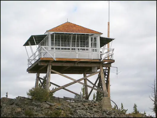
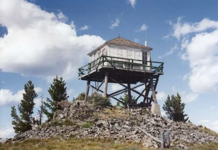
Medicine Point Lookout, a CCC-era L-4 cab in Montana's Bitterroot Mountains staffed into 1976, was restored in 1999 and is now a hike-in Forest Service rental.
- Standing
- Rentable
- Open to the public
- Verified
Visit & stay
You can rent this lookout for overnight stays through recreation.gov.
- Getting there
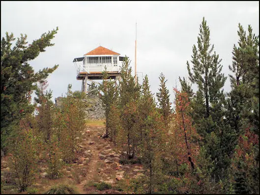
- The tower is accessed by a somewhat difficult 3.5-mile hike from the parking area with a 2,000 foot elevation gain.
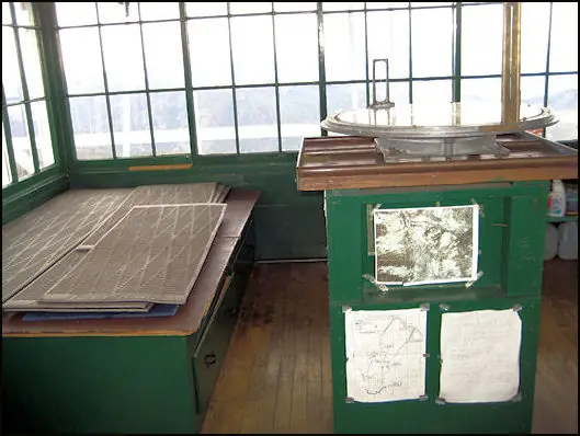
Overview Medicine Point Lookout is a historic tower located on Medicine Point, west of Sula. It has been restored to reflect a lookout of the 1940s, including the stove, furniture, dishes and other small touches. It offers a unique chance for visitors to camp on a mountain peak, near the scenic Bitterroot River in a rustic, old-time setting, while having the enjoyment of recreating on public lands. The tower provides spectacular views of the surrounding western Montana wilderness. Recreation An extensive trail system exists in the area, including several loop trails for hiking, backpacking and horseback riding. Hitching racks are available at the base of the tower for equestrian campers' needs. Road and trail conditions are unpredictable, as weather changes quickly in the area. For best results, consult the ranger district prior to travel. Aside from hiking and horseback riding, the area is replete with wildlife and offers scenic views. A lookout journal is kept inside, providing instructions of what to do in case of emergency or a storm. Danger from lightning is largely abated due to a lightning rod implanted at the structure. Facilities Medicine Point Lookout is a historic "L4" lookout located on Medicine Point, west of the Bitterrot Valley. The lookout is one room cabin with a bed platform suitable for two people. Bedding is not provided. The lookout can accomidate up to four people. Others are welcome to tent camp in the area. The lookout measures 14ft.X14ft. with a 30 inch catwalk around the outside. There is wood stove for heat. You may have to saw your own wood from dead and down material found nearby. A bow saw and ax are provided. A two burner propane campstove and lanterns are provided. Propane is not provided, you will need to bring your own propane canisters. Basic eating and cooking utensils are provided. There is no water available near the lookout so please bring your own water. An outdoor toilet serves the lookout. You will need to provide your own toilet paper. The lookout is built on a 10 foot tall tower, with narrow steps and catwalk. This may pose a hazard for children and pets. Guests are responsible for their own safety. Remember, guests will need to bring their own water for drinking, cooking and cleaning purposes, as well as propane fuel canisters for cooking and lighting. Guests are also responsible for their own bedding, towels, soap, toilet paper and garbage bags. The facility does not provide trash receptacles; all garbage must be carried out, and the tower must be cleaned by guests prior to leaving. Do not leave anything you bring, even if you think it will benefit other renters. The tower is accessed by a somewhat difficult 3.5-mile hike from the parking area with a 2,000 foot elevation gain. Snowmobiles and other off-road vehicles are not allowed on the trail, however, horses and other livestock are welcome. Guests are responsible for their own travel arrangements and safety, and must bring several of their own amenities. Natural Features The tower is poised between the east and west forks of the Bitterroot River at an elevation of 8,409 feet. It offers beautiful views of the Bitterroot Mountains, as well as a vista of the southern Bitterroot Valley to the east. On clear nights the lights of Hamilton can be seen from the tower. The Bitterroot forest is home to many species of wildlife, from mule deer, whitetail deer, elk, bighorn sheep, mountain goats, black bear, mountain lions and moose to many varieties of smaller animals and birds.
Book on recreation.gov (opens recreation.gov)
Rental details from recreation.gov, checked 12 Oct 2026. Rules, fees and seasons change, so confirm on the booking page before you go. Data source: ridb.recreation.gov
Access
Open to the public. Forest Service rental via Recreation.gov; hike-in only, no vehicle access.
- Can you climb it?
- Yes
- Road to the top?
- No, you have to hike
- Trail
- 3.5-mile hike with about 2,000 feet of elevation gain; no ATVs/OHVs; horses allowed.
- Staffing
- Not staffed (as of 1976)
Facts
- Status
- Type
- Cab on a towerL-4 cab, pyramid roof, on an 8-10 foot wood/pole towerThe design: L-4
- Built of
- Wood
- Built
- 1930
- Height
- 10 ft (3.0 m)
- Elevation
- 8,316 ft (2,535 m)
- Agency
- U.S. Forest Service
- Land
- Federal land
- Location
- Ravalli County, Montana
- Coordinates
- 45.80663, −114.10985
- Registers
- This entry
- VerifiedResearched, then checked independently. Updated 12 Oct 2026.
- Firefinder id
us-mt-medicine-point
View from the cab
What you see from the cab: every ridge out to about 93 miles, the named peaks in sight, and other fire lookouts within view, worked out from terrain data in your browser.
Downloads about 4.1 MB of terrain data the first time.
Or see what it could see on the map: the ground in its line of sight.
History
Then and now
- 1930 BuiltNHLR: tower constructed by the CCC in 1930.Source: nhlr.org
- 1933 AlteredNHLR: pyramid roof L-4 cab added atop the tower.Source: nhlr.org
- 1940 BuiltFirelookout.com gives 1940 as the build year for the L-4 cab on a 10-foot pole tower (conflicts with NHLR's 1930/1933 dates).Source: firelookout.com
- 1946 StaffedEarliest recorded lookout staff: Mr. and Mrs. Raymond Barnett.Source: firelookout.com
- No record between 1946 and 1976
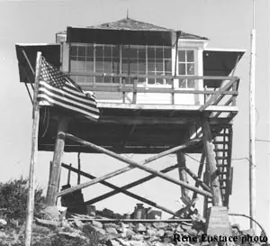
- 1976 Last staffedLast recorded staffing year, lookout Rene Eustace.Source: firelookout.com
- No record between 1976 and 1999
- 1999 Added to the National Historic Lookout RegisterDate registered per NHLR detail page: October 8, 1999Source: NHLR register entry
- 1999 RestoredTower restored; NHLR registration dated October 8, 1999.Source: nhlr.org
- TodayStandingIt still stands, as far as our sources know.
Old maps of this spot
USGS topographic maps from the years a lookout stood may show it, often as a small symbol labelled “Lookout”. See the old topo maps around it on the Firefinder map, or find every scanned sheet of this spot on USGS TopoView (opens another site) (click the spot there to list them, with dates and downloads).
Story
Researched 4 Oct 2026, fact-checked.
Medicine Point Lookout sits in the Bitterroot Mountains about 15 miles south of Darby, Montana, on land that's now part of the Bitterroot National Forest. Accounts of exactly when it went up differ: the National Historic Lookout Register says the Civilian Conservation Corps put up the tower in 1930, then added a pyramid-roof L-4 cab in 1933, resting it on an 8-foot wooden support.1 Firelookout.com instead gives 1940 as the build year for a similar L-4 cab on a 10-foot pole tower.2 The National Register of Historic Places nomination lists 1939 as the structure's period of significance, which sits closer to the earlier date.3 Whichever year is right, the cab itself is small: a 14-foot square with a 30-inch-wide walkway wrapping around it.4
A number of lookouts staffed Medicine Point over the following decades. The earliest name on record is Mr. and Mrs. Raymond Barnett in 1946, followed over the years by Jack and his wife Schlager, Mr. and Mrs. Dale Dye, Luther Britton (in both 1957 and 1959), Walter Martin, Ralph Robinson III, Jim Fazio, Bill Friermuth, Kelsey Milner, James Maclean, Del Reynolds, Jim Kautz, and finally Rene Eustace in 1976, the last recorded staffing year.2 The National Historic Lookout Register notes it was used only sporadically through the 1980s before going quiet.1,2
The tower was restored in 1999 and furnished to reflect its 1940s working days, down to a period stove, furniture, and dishes.1,4 It was added to the National Historic Lookout Register that October and later listed on the National Register of Historic Places.1,3
Medicine Point is public land administered by the Forest Service and open to rental through Recreation.gov. It's not a drive-up site: reaching it takes a roughly 3.5-mile hike with about 2,000 feet of elevation gain, and snowmobiles and other off-road vehicles aren't allowed on the trail, though horses are.4 The cab sleeps up to four, has a wood stove, and comes with a bow saw and ax for cutting firewood, but no running water — renters need to bring their own.4
- Medicine Point Lookout, National Historic Lookout Register, http://nhlr.org/lookouts/us/mt/medicine-point-lookout/ (accessed 2026-10-04). ↩
- Medicine Point Fire Lookout Tower, Firelookout.com, https://www.firelookout.com/mt/medicinept.html (accessed 2026-10-04). ↩
- National Register of Historic Places nomination (Asset 100002298), National Park Service NPGallery, https://npgallery.nps.gov/AssetDetail/NRIS/100002298 (accessed 2026-10-04). ↩
- Medicine Point Lookout, Recreation.gov, https://www.recreation.gov/camping/campgrounds/234296 (accessed 2026-10-04). ↩
Photos
Photos keep their own rights and are shown with credit. Is one of these yours? You can ask for a different credit or for removal.
Sources
- National Historic Lookout Register (NHLR) (opens another site) Gave us: name, location, county, elevation, what it is built of, register numbers, agency, dates, photos, links National Historic Lookout Register (nhlr.org) · All rights reserved (American Resources, Inc.); facts extracted only, no prose copied. · retrieved 4 Oct 2026
- Forest Fire Lookout Association (FFLA) - US lookout lists (opens another site) Gave us: type, status, register numbers, links Forest Fire Lookout Association (firelookout.org) · No licence stated; facts extracted only, no prose copied. · retrieved 8 Oct 2026
- Recreation Information Database (recreation.gov) (opens another site) Gave us: ownership, access, rental details, links Data source: ridb.recreation.gov · Public data from the US government · retrieved 12 Oct 2026
- Forest Fire Lookout Association: lookout rentals (opens another site) Gave us: rental details, links Forest Fire Lookout Association rentals list (firelookout.org) · No licence stated; facts extracted only (state, name, booking link, manager, closure note), no prose copied. The FFLA says it is not involved in managing any rental program. · retrieved 12 Oct 2026
- firelookout.com -- Rex Kamstra's Forest Fire Lookout Page (opens another site) Gave us: design, height, dates, photos, links firelookout.com · No licence stated on the site; facts only (coordinates, elevation, built/destroyed years, design, agency). Photos mirrored with the site's stated credit. · retrieved 4 Oct 2026
- Wikidata -- US fire lookout towers (Q748998 and subclasses) (opens another site) Gave us: register numbers, links Wikidata · CC0 1.0 (Wikidata). Images keep their own Commons licence/credit. · retrieved 4 Oct 2026
- OpenStreetMap -- fire lookout structures (opens another site) Gave us: links © OpenStreetMap contributors · ODbL 1.0. (c) OpenStreetMap contributors. · retrieved 4 Oct 2026
- FOREST LOOKOUTS -- western US (Ron Kemnow's weebly sites) (opens another site) Gave us: links Ron Kemnow's Forest Lookouts sites (westlookouts, californialookouts, idaholookouts, montanalookouts, oregonlookouts and washingtonlookouts .weebly.com) · No licence stated; facts only (county, land manager, status word, coordinates where the page's own map widget gives them, township-range-section, height and design hints, links). The site's own newspaper quotes, citations and narrative are not reproduced. · retrieved 8 Oct 2026
- Firefinder research Gave us: summary, design, height, status, agency, access, staffing, visiting details, dates, links, fact-check Firefinder research (sources cited in the story footnotes) · Our own research notes; each fact cites its source in the lookout's story
More about this lookout elsewhere
- NHLR register entry US 323 (nhlr.org) (opens another site)
- Recreation.gov listing (opens another site)
- National Register of Historic Places nomination (Asset 100002298) (National Park Service NPGallery) (opens another site)
- FFLA Montana lookout list (firelookout.org) (opens another site)
- FFLA lookout rentals list (firelookout.org) (opens another site)
- Medicine Point on firelookout.com (Rex Kamstra) (opens another site)
- Medicine Point on Forest Lookouts, western US (Ron Kemnow) (opens another site)
- Website (fs.usda.gov) (opens another site)
- Wikidata item Q86927343 (opens another site)
- OpenStreetMap node 3925434952 (opens another site)
Firefinder takes facts (places, dates, numbers) from these sources and writes its own words. See all sources and licences.