Fire lookout · Sanders County, Montana
Minton Peak Lookout
Kootenai National Forest lookout rebuilt in 2011 after earlier 1932 and 1960s-era towers; now a car-accessible rental.
- Standing
- Rentable
- Open to the public
- Verified
Visit & stay
You can rent this lookout for overnight stays through recreation.gov.
- Season
- late June through mid-October and is accessible by car
- Sleeps
- Up to 4 people
- Getting there
- The lookout is typically open from late June through mid-October and is accessible by car.
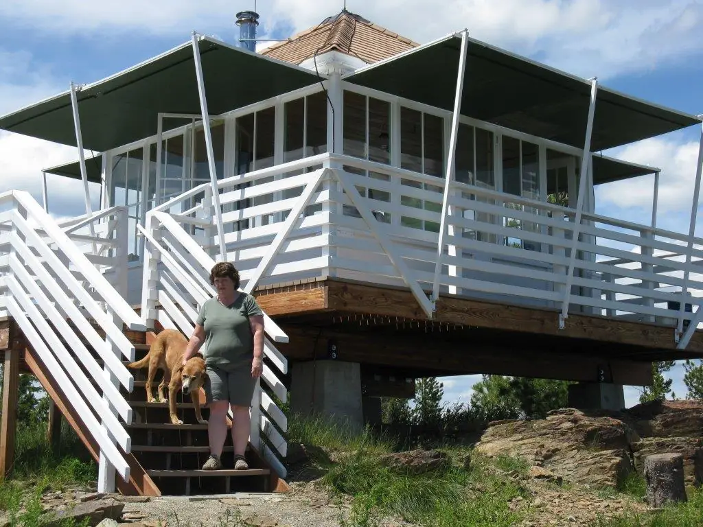
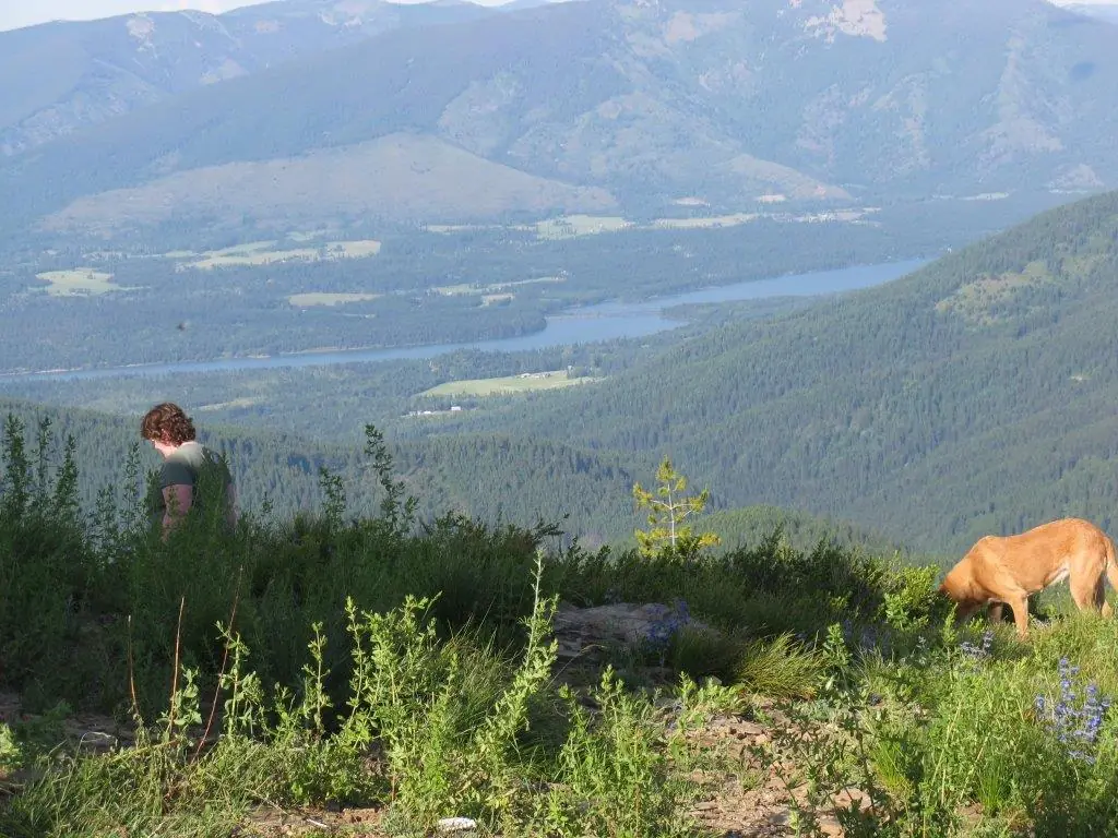
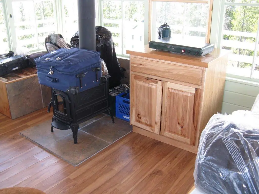
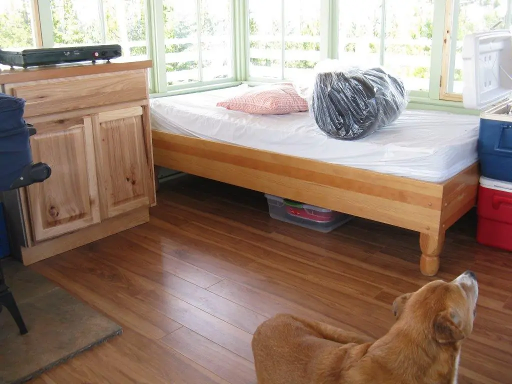
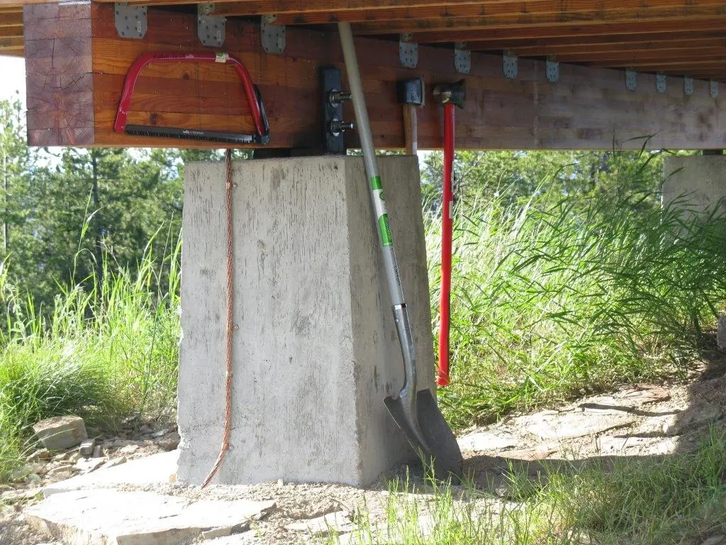
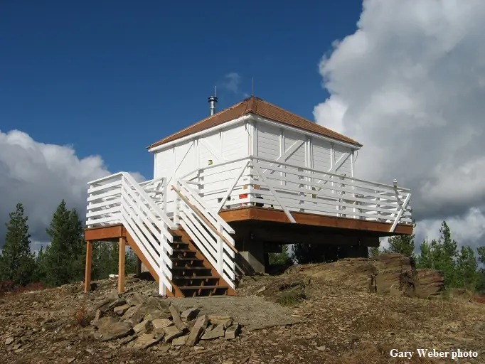
Overview Minton Peak Lookout is situated in the Rocky Mountains at an elevation of 5,351 feet in the Kootenai National Forest. The original lookout was constructed in 1932, replaced in 1968, and completely rebuilt in 2011. The mountain was named after Col. David Minton, an Ohio cavalryman who homesteaded (and is buried) near the mouth of Minton Creek. The lookout is typically open from late June through mid-October and is accessible by car. This rustic retreat offers a few amenities, but guests should pack in most of their own supplies and gear. Recreation Mountain roads and scenic trails provide access to explore the area. Facilities The 14x14 foot cabin sits on a five foot tower. The lookout has windows on all sides and is encircled by a catwalk. The cabin sleeps four people and is equipped with two twin size beds with mattresses. Other amenities include a table and chairs, wood stove for heat, two-burner cooktop (propane not provided), broom and dustpan. Firewood is provided. An outhouse with a vault toilet and a campfire ring are located outside. The lookout does not have electricity or water. Guests should bring enough water for drinking, cooking and cleaning. Items such as cooking gear, bedding, lanterns, matches, extra toilet paper, trash bags, dish soap and towels are not available. Natural Features The lookout sits five feet off the ground and is surrounded by an evergreen forest. It offers panoramic views of the Clark Fork Valley, the Bitterroot Mountains to the west and the Cabinet Range to the east. This is an ideal vantage point to enjoy sunrises and sunsets and gaze out at starry skies on clear nights.
Book on recreation.gov (opens recreation.gov)
Rental details from recreation.gov, checked 19 Oct 2026. Rules, fees and seasons change, so confirm on the booking page before you go. Data source: ridb.recreation.gov
Access
Open to the public. Car accessible; rented through Recreation.gov, late June through mid-October.
- Can you climb it?
- Yes
- Road to the top?
- Yes, you can drive up
- Trail
- Mountain roads lead directly to the lookout; access depends on weather.
- Staffing
- Unknown
Facts
- Status
- Type
- Cab on a towerL-4The design: L-4
- Built of
- Wood
- Built
- 1932 sources disagree
- Height
- 5 ft (1.5 m)
- Elevation
- 5,351 ft (1,631 m)
- Agency
- U.S. Forest Service (Kootenai National Forest)
- Land
- Federal land
- Location
- Sanders County, Montana
- Coordinates
- 47.82835, −115.77100
- Registers
- This entry
- VerifiedResearched, then checked independently. Updated 19 Oct 2026.
- Firefinder id
us-mt-minton-peak
View from the cab
What you see from the cab: every ridge out to about 93 miles, the named peaks in sight, and other fire lookouts within view, worked out from terrain data in your browser.
Downloads about 4.3 MB of terrain data the first time.
Or see what it could see on the map: the ground in its line of sight.
History
Then and now
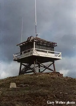
- 1932 BuiltFirst lookout: a 10-foot pole tower with L-4 cab.Source: firelookout.com
- No record between 1932 and 1968
- 1968 Replaced by a new structureNHLR dates a replacement tower to 1968; firelookout.com instead describes a treated-timber tower from the 1950s, so the exact year is disputed.Sources: nhlr.org, firelookout.com
- 1973 Last staffedLast year the lookout is recorded as staffed.Source: firelookout.com
- No record between 1973 and 2011
- 2011 Built'Built' field on NHLR detail pageSource: NHLR register entry
- 2011 RebuiltPresent 5-foot tower with replica L-4 cab built, entering the recreation rental program.Sources: nhlr.org, firelookout.com
- 2011 Replaced by a new structureAll-new replacement lookout built with ARRA stimulus funding, planned to be ready for the rental program by mid-summer.Source: firelookout.org
- 2014 Added to the National Historic Lookout RegisterRegistered on the National Historic Lookout Register, September 3, 2014.Source: nhlr.org
- TodayStandingIt still stands, as far as our sources know.
Old maps of this spot
USGS topographic maps from the years a lookout stood may show it, often as a small symbol labelled “Lookout”. See the old topo maps around it on the Firefinder map, or find every scanned sheet of this spot on USGS TopoView (opens another site) (click the spot there to list them, with dates and downloads).
Story
Researched 4 Oct 2026, fact-checked.
Minton Peak, in Montana's Kootenai National Forest, takes its name from Col. David Minton, an Ohio cavalryman who homesteaded near the mouth of Minton Creek and is buried there.1,2 The first lookout on the peak was a 10-foot pole tower with an L-4 cab, built in 1932.1 That structure was later replaced by a new tower, which sources date either to the 1950s or to 1968; the National Historic Lookout Register gives 1968, while the Fire Lookout website describes a treated-timber tower going up in the 1950s, so the exact year of this middle structure is unclear.3,1
The lookout was staffed into the early 1970s. Fire Lookout's personnel listing names Helen Ahlgren as a staffer in 1967, and the site records 1973 as the year the lookout was last staffed.1
In 2011 the Forest Service completely rebuilt the lookout, putting up a new 5-foot tower topped with a replica L-4 cab.3,1 It was added to the agency's recreation rental program and listed on the National Historic Lookout Register in 2014.3
Today Minton Peak Lookout sits at 5,351 feet and is reachable by car, with the rental season running from late June through mid-October.2 It sleeps up to four guests, though there's no water on-site, so visitors need to pack in their own supplies and pack out their trash.2 Reservations go through Recreation.gov under the Kootenai National Forest.2
- Minton Peak Fire Lookout Tower, firelookout.com, https://www.firelookout.com/mt/mintonpk.html (accessed 2026-10-04). ↩
- Minton Peak Lookout campground listing, Recreation.gov, https://www.recreation.gov/camping/campgrounds/250012 (accessed 2026-10-04). ↩
- Minton Peak Lookout, National Historic Lookout Register, http://nhlr.org/lookouts/us/mt/minton-peak-lookout/ (accessed 2026-10-04). ↩
Photos
Photos keep their own rights and are shown with credit. Is one of these yours? You can ask for a different credit or for removal.
Where sources disagree
We show disagreements between sources instead of quietly picking one. If you know which is right, please tell us.
Sources disagree on the year it was built.
- NHLR: 2011
- firelookout.com -- Rex Kamstra's Forest Fire Lookout Page: 1932
- recreation.gov: 2011
Sources give different build years. Often one counts the first lookout on the site and another the structure there now.
Sources
- National Historic Lookout Register (NHLR) (opens another site) Gave us: name, location, county, elevation, register numbers, agency, dates, photos, links National Historic Lookout Register (nhlr.org) · All rights reserved (American Resources, Inc.); facts extracted only, no prose copied. · retrieved 4 Oct 2026
- Forest Fire Lookout Association (FFLA) - US lookout lists (opens another site) Gave us: type, status, register numbers, links Forest Fire Lookout Association (firelookout.org) · No licence stated; facts extracted only, no prose copied. · retrieved 8 Oct 2026
- Recreation Information Database (recreation.gov) (opens another site) Gave us: ownership, access, rental details, links Data source: ridb.recreation.gov · Public data from the US government · retrieved 19 Oct 2026
- Forest Fire Lookout Association: lookout rentals (opens another site) Gave us: rental details, links Forest Fire Lookout Association rentals list (firelookout.org) · No licence stated; facts extracted only (state, name, booking link, manager, closure note), no prose copied. The FFLA says it is not involved in managing any rental program. · retrieved 19 Oct 2026
- firelookout.com -- Rex Kamstra's Forest Fire Lookout Page (opens another site) Gave us: what it is built of, design, height, photos, links firelookout.com · No licence stated on the site; facts only (coordinates, elevation, built/destroyed years, design, agency). Photos mirrored with the site's stated credit. · retrieved 4 Oct 2026
- Forest Fire Lookout Association chapter reports (opens another site) Gave us: dates, links Forest Fire Lookout Association, chapter and restoration-grant reports (firelookout.org) · No licence stated; facts only (dates, names, the kind of work done). Every note is our own wording and every event links to the FFLA report it comes from. Positions are copied from the NHLR, FFLOS and FFLA records. · retrieved 8 Oct 2026
- OpenStreetMap -- fire lookout structures (opens another site) Gave us: links © OpenStreetMap contributors · ODbL 1.0. (c) OpenStreetMap contributors. · retrieved 4 Oct 2026
- FOREST LOOKOUTS -- western US (Ron Kemnow's weebly sites) (opens another site) Gave us: links Ron Kemnow's Forest Lookouts sites (westlookouts, californialookouts, idaholookouts, montanalookouts, oregonlookouts and washingtonlookouts .weebly.com) · No licence stated; facts only (county, land manager, status word, coordinates where the page's own map widget gives them, township-range-section, height and design hints, links). The site's own newspaper quotes, citations and narrative are not reproduced. · retrieved 8 Oct 2026
- Firefinder research Gave us: summary, design, height, status, agency, access, visiting details, dates, links, fact-check Firefinder research (sources cited in the story footnotes) · Our own research notes; each fact cites its source in the lookout's story
More about this lookout elsewhere
- NHLR register entry US 1043 (nhlr.org) (opens another site)
- Recreation.gov listing (opens another site)
- FFLA Montana lookout list (firelookout.org) (opens another site)
- FFLA lookout rentals list (firelookout.org) (opens another site)
- Forest Fire Lookout Association chapter reports: work on Minton Peak Lookout (opens another site)
- Koontenai National Forest page about Minton Peak Lookout (opens another site)
- Minton Peak on firelookout.com (Rex Kamstra) (opens another site)
- Minton Peak on Forest Lookouts, western US (Ron Kemnow) (opens another site)
- OpenStreetMap way 944367488 (opens another site)
Firefinder takes facts (places, dates, numbers) from these sources and writes its own words. See all sources and licences.