Fire lookout · Rosebud County, Montana
Poker Jim Butte Fire Lookout
Also known as Poker Jim
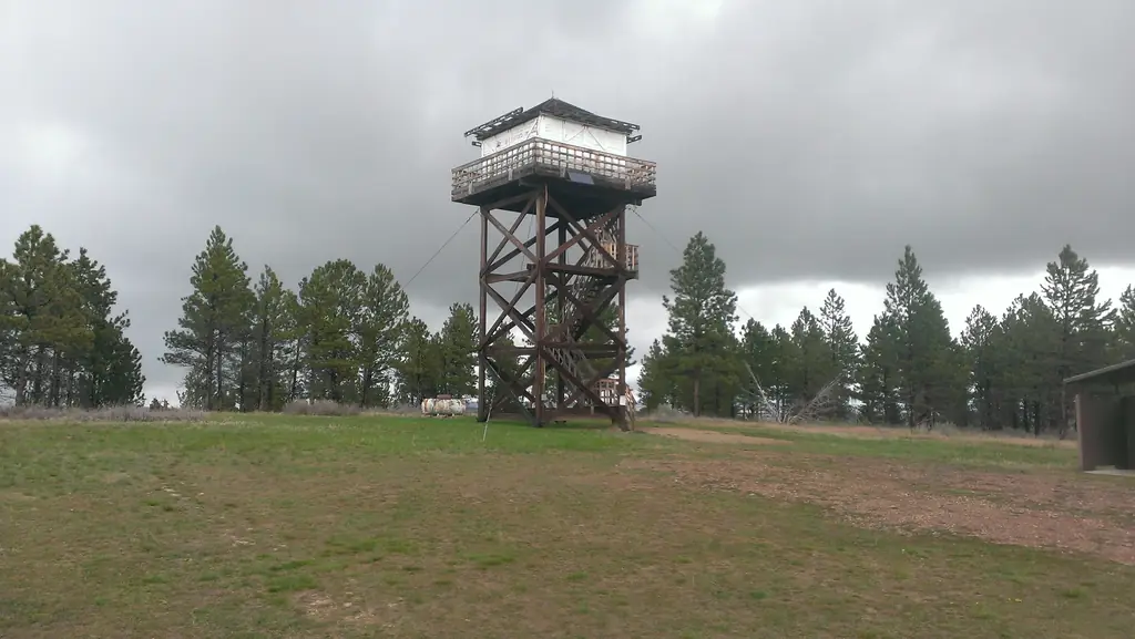
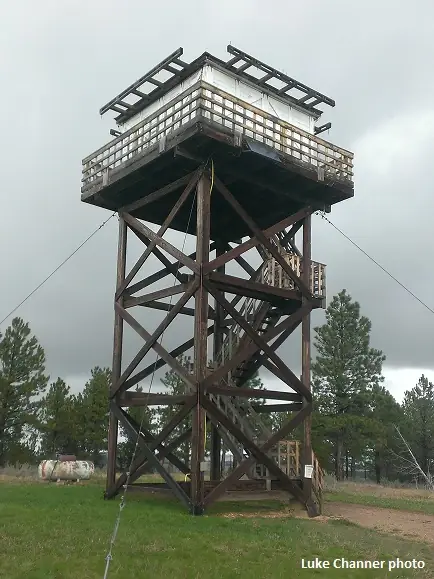
Standing 1955 L-4 lookout cab on a 30-foot tower on Poker Jim Butte in the Custer Gallatin forest, NRHP-listed 2022, with a drive-up road.
- Standing
- Access unknown
- Verified
Visit & stay
Not rentable. As far as we know, this lookout cannot be booked for overnight stays.
Access
Access unknown
We do not know the access rules. Check with the land manager before you go. A road runs to the top of the butte beside the Poker Jim Picnic Ground. No source says whether the cab is open to visitors.
- Can you climb it?
- Unknown
- Road to the top?
- Yes, you can drive up
- Staffing
- Unknown
Facts
- Status
- Type
- Cab on a towerL-4 pattern lookout cab (14 by 14 ft) on a 30-foot timber towerThe design: L-4
- Built of
- Wood
- Built
- 1936
- Height
- 30 ft (9.1 m)
- Elevation
- 4,325 ft (1,318 m)
- Agency
- U.S. Forest Service
- Land
- Federal land
- Location
- Rosebud County, Montana
- Coordinates
- 45.32482, −106.36552
- Registers
- This entry
- VerifiedResearched, then checked independently. Updated 8 Oct 2026.
- Firefinder id
us-mt-poker-jim-butte
View from the cab
What you see from the cab: every ridge out to about 93 miles, the named peaks in sight, and other fire lookouts within view, worked out from terrain data in your browser.
Downloads about 4.0 MB of terrain data the first time.
Or see what it could see on the map: the ground in its line of sight.
History
Then and now
- 1936 BuiltFirst lookout on the summit; the NRHP nomination puts a lookout there by spring 1936. Other sources give 1935 or 1937.Sources: fs.usda.gov, montanalookouts.weebly.com
- 1937 StaffedA lookout and his wife stationed on the peak all summer; register recorded 186 tourists from 19 statesSource: montanalookouts.weebly.com
- No record between 1937 and 1955
- 1955 BuiltPresent L-4 cab built on a 30-foot towerSources: nhlr.org, fs.usda.gov, fs.usda.gov
- 1955 Replaced by a new structureOriginal lookout removed and replaced by the present L-4 cab on a 30-foot towerSources: nhlr.org, fs.usda.gov
- 1966 FireBlazes in the Ashland and Fort Howes districts; the lookout tower was evacuatedSource: montanalookouts.weebly.com
- No record between 1966 and 2008
- 2008 RestoredStairs, rails, catwalk deck and floor joists replaced to address safety problemsSource: fs.usda.gov
- 2016 Added to the National Historic Lookout RegisterRegistered November 27, 2016 as US 1156, MT 65Source: nhlr.org
- 2022 Listed on the National Register of Historic PlacesListed on the National Register of Historic Places September 1, 2022Source: fs.usda.gov
- TodayStandingIt still stands, as far as our sources know.
Old maps of this spot
USGS topographic maps from the years a lookout stood may show it, often as a small symbol labelled “Lookout”. See the old topo maps around it on the Firefinder map, or find every scanned sheet of this spot on USGS TopoView (opens another site) (click the spot there to list them, with dates and downloads).
Story
Researched 8 Oct 2026, fact-checked.
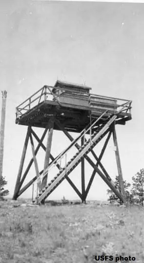
Poker Jim Butte rises in the Custer Gallatin National Forest, about 18 miles south-southwest of Ashland, Montana.1,2 The first lookout on the summit was a 20-foot pole tower with an undersized cab.1 The sources do not agree on when it went up.3,1,2,4 The Forest Service's National Register nomination says a lookout was present by the spring of 1936, though one passage gives 1935.2 A September 1937 newspaper said the tower had been built the previous spring, while the National Historic Lookout Register and FirelookOut both give 1937.4,3,1
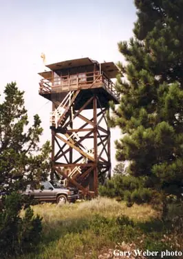
The present cab replaced it.3 The L-4 cab, built in 1955, sits on a 30-foot timber tower.3,5 It is a pre-cut 14-by-14-foot frame under a hip roof, and the nomination says this kind of structure was once common throughout the Forest Service's Northern Region.2
In the summer of 1937 a lookout and his wife were stationed on the peak, and their register recorded 186 tourists from 19 states.4 In July 1966 blazes burned in the Ashland and Fort Howes districts, and the Forest Service's Poker Jim tower was evacuated.4 In 2008 crews replaced the stairs, rails, catwalk deck and floor joists to fix safety problems caused by deteriorating materials.2
The nomination describes the cab as intact and still in working order as an L-4 house.2 The National Historic Lookout Register registered it on November 27, 2016,3 and the National Register of Historic Places listed it on September 1, 2022.5
The nomination says the Forest Service still staffs the lookout through summer and fall.2 FirelookOut describes it as used during emergencies, so the current pattern of use is not settled.1 A road runs to the top of the butte, and the lookout sits beside the Poker Jim Picnic Ground.4,2 None of the sources says whether the cab is open to visitors, so check with the Custer Gallatin National Forest before going up.
- Poker Jim Fire Lookout Tower, FireLookout.com, https://www.firelookout.com/mt/pokerjim.html (accessed 2026-10-08). ↩
- Poker Jim Butte Fire Lookout, National Register of Historic Places Registration Form, U.S. Forest Service, https://www.fs.usda.gov/sites/nfs/files/legacy-media/custergallatin/Poker%20Jim%20NRHP%20Nom%20Form.pdf (accessed 2026-10-08). ↩
- Poker Jim Butte, National Historic Lookout Register, http://nhlr.org/lookouts/us/mt/poker-jim-butte/ (accessed 2026-10-08). ↩
- Poker Jim - Forest Lookouts, Montana Lookouts (montanalookouts.weebly.com), https://montanalookouts.weebly.com/poker-jim.html (accessed 2026-10-08). ↩
- National Register of Historic Places, Custer Gallatin National Forest, U.S. Forest Service, https://www.fs.usda.gov/r01/custergallatin/recreation/discover-history/national-register-historic-places (accessed 2026-10-08). ↩
Photos
Photos keep their own rights and are shown with credit. Is one of these yours? You can ask for a different credit or for removal.
Sources
- National Historic Lookout Register (NHLR) (opens another site) Gave us: name, location, county, elevation, what it is built of, register numbers, agency, ownership, dates, photos, links National Historic Lookout Register (nhlr.org) · All rights reserved (American Resources, Inc.); facts extracted only, no prose copied. · retrieved 4 Oct 2026
- Forest Fire Lookout Association (FFLA) - US lookout lists (opens another site) Gave us: type, status, register numbers, links Forest Fire Lookout Association (firelookout.org) · No licence stated; facts extracted only, no prose copied. · retrieved 8 Oct 2026
- firelookout.com -- Rex Kamstra's Forest Fire Lookout Page (opens another site) Gave us: design, height, photos, links firelookout.com · No licence stated on the site; facts only (coordinates, elevation, built/destroyed years, design, agency). Photos mirrored with the site's stated credit. · retrieved 4 Oct 2026
- Wikidata -- US fire lookout towers (Q748998 and subclasses) (opens another site) Gave us: register numbers, links Wikidata · CC0 1.0 (Wikidata). Images keep their own Commons licence/credit. · retrieved 4 Oct 2026
- FOREST LOOKOUTS -- western US (Ron Kemnow's weebly sites) (opens another site) Gave us: links Ron Kemnow's Forest Lookouts sites (westlookouts, californialookouts, idaholookouts, montanalookouts, oregonlookouts and washingtonlookouts .weebly.com) · No licence stated; facts only (county, land manager, status word, coordinates where the page's own map widget gives them, township-range-section, height and design hints, links). The site's own newspaper quotes, citations and narrative are not reproduced. · retrieved 8 Oct 2026
- Firefinder research Gave us: summary, design, height, status, agency, access, visiting details, dates, links, fact-check Firefinder research (sources cited in the story footnotes) · Our own research notes; each fact cites its source in the lookout's story
More about this lookout elsewhere
- NHLR register entry US 1156 (nhlr.org) (opens another site)
- Poker Jim Butte Fire Lookout, National Register of Historic Places Registration Form (U.S. Forest Service, Custer Gallatin National Forest) (opens another site)
- National Register of Historic Places (U.S. Forest Service, Custer Gallatin National Forest) (opens another site)
- FFLA Montana lookout list (firelookout.org) (opens another site)
- Poker Jim on firelookout.com (Rex Kamstra) (opens another site)
- Poker Jim on Forest Lookouts, western US (Ron Kemnow) (opens another site)
- Wikidata item Q86926993 (opens another site)
Firefinder takes facts (places, dates, numbers) from these sources and writes its own words. See all sources and licences.