Fire lookout · Ravalli County, Montana
St. Mary Peak Lookout
Also known as Saint Mary Lookout
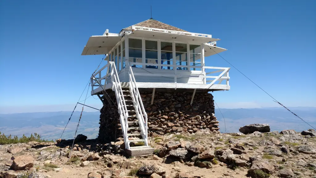
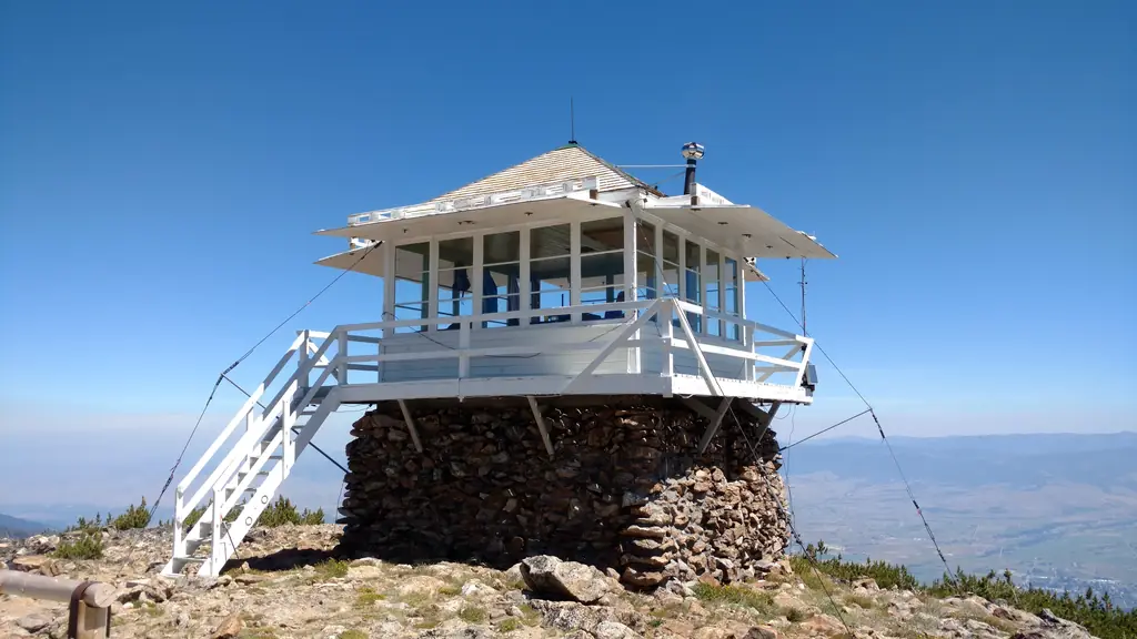
A 1953 L-4 cab on a stone base atop St. Mary Peak in the Selway-Bitterroot Wilderness, closed in 1972, now staffed by summer volunteers; first-lookout dates disagree.
- Standing
- Open to the public
- Verified
Visit & stay
Not rentable. As far as we know, this lookout cannot be booked for overnight stays.
Access
Open to the public. Reached only on foot by trail in the Selway-Bitterroot Wilderness; volunteers host visitors in summer. No closure was found in the sources read.
- Can you climb it?
- Unknown
- Road to the top?
- No, you have to hike
- Trail
- A 3.8-mile trail climbs to the summit, according to the volunteer history.
- Staffing
- Staffed by volunteers
Facts
- Status
- Type
- Two-story building1936-pattern L-4 hip-roof cab (14 x 14 ft) on a stone base, completed 1953The design: L-4
- Built of
- Wood
- Built
- 1934 sources disagree
- Height
- 40 ft (12.2 m)
- Elevation
- 9,241 ft (2,817 m)
- Agency
- U.S. Forest Service, Bitterroot National Forest (Stevensville Ranger District)
- Land
- Federal land
- Location
- Ravalli County, Montana
- Coordinates
- 46.51102, −114.24402
- Registers
- This entry
- VerifiedResearched, then checked independently. Updated 8 Oct 2026.
- Firefinder id
us-mt-st-mary-peak
View from the cab
What you see from the cab: every ridge out to about 93 miles, the named peaks in sight, and other fire lookouts within view, worked out from terrain data in your browser.
Downloads about 3.8 MB of terrain data the first time.
Or see what it could see on the map: the ground in its line of sight.
History
Then and now
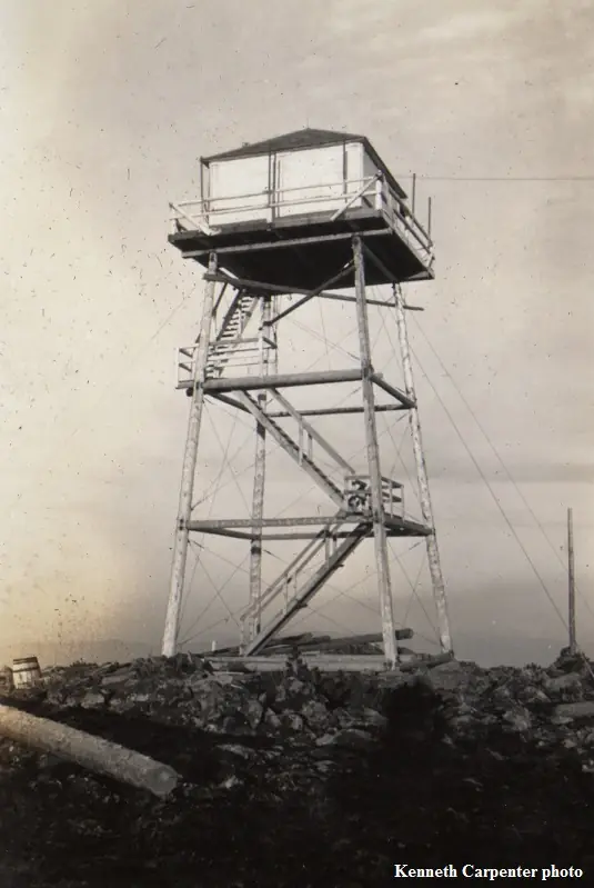
- 1931 EventNHLR and firelookout.com date a 40-ft pole tower with an L-4 cab to 1931. A 1982 memo cited in the nomination dates the first known fire report from the site to 1931.Sources: nhlr.org, firelookout.com, npgallery.nps.gov
- 1934 BuiltForest improved the site with a lookout house on a 40-ft pole tower (nomination). The volunteer history says CCC built a 50-ft tower in 1934.Sources: npgallery.nps.gov, selwaybitterroot.org
- 1942 First staffedEarliest named lookout on firelookout.com's list (Bob Brown, 1942-1943). Staffing before 1952 is disputed.Source: firelookout.com
- 1951 DestroyedViolent windstorm blew the cab 100 ft down the mountain (nomination); volunteer history says high winds destroyed the lookout in spring 1951.Sources: npgallery.nps.gov, selwaybitterroot.org
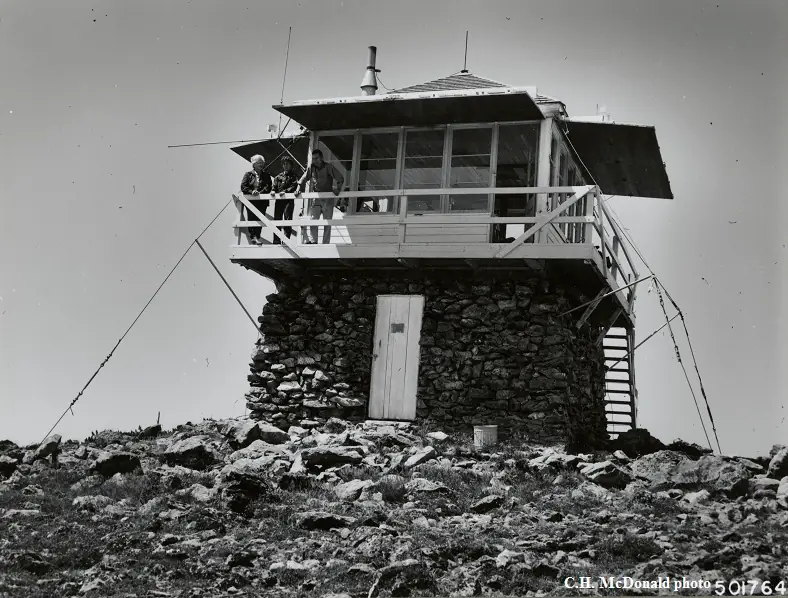
- 1953 BuiltCurrent 1936-pattern L-4 cab on a stone base completed for $4,970; replaced the earlier lookout structure. Firelookout.com says 1952.Sources: npgallery.nps.gov, nhlr.org, selwaybitterroot.org
- 1956 EventAugust 1956 inspection by the Assistant Forest Supervisor; regional inspectors began to question the lookout's usefulness for detecting fires in the Bitterroot Valley.Source: npgallery.nps.gov
- No record between 1956 and 1972
- 1972 ClosedForest Service closed the lookout because of visibility problems from fog and low clouds, and because of rocky alpine terrain in its viewshed (volunteer history).Source: selwaybitterroot.org
- 1975 StaffedUnpaid volunteers stationed at the lookout from 1975 (nomination). This conflicts with the 1972 closure in the volunteer history.Source: npgallery.nps.gov
- 1977 StaffedStaffed intermittently by paid staff and volunteers from 1977 until 2009 (volunteer history).Source: selwaybitterroot.org
- No record between 1977 and 1992
- 1992 Added to the National Historic Lookout RegisterRegistered on the National Historic Lookout Register, November 27, 1992.Source: nhlr.org
- 1998 RestoredVolunteers working under the Passport in Time program restored the exterior.Sources: npgallery.nps.gov, selwaybitterroot.org
- 2008 RestoredCedar shingle roof replaced in kind.Source: npgallery.nps.gov
- TodayStandingIt still stands, as far as our sources know.
Old maps of this spot
USGS topographic maps from the years a lookout stood may show it, often as a small symbol labelled “Lookout”. See the old topo maps around it on the Firefinder map, or find every scanned sheet of this spot on USGS TopoView (opens another site) (click the spot there to list them, with dates and downloads).
Story
Researched 8 Oct 2026, fact-checked.
St. Mary Peak Lookout sits on the summit of St. Mary Peak in the Bitterroot National Forest, in Ravalli County, Montana.1,2 The site is a trail destination: the nomination calls it remote and accessible only by trail, and the volunteer history describes a 3.8-mile trail to the summit.2,3
The first lookout is hard to date. The NHLR and firelookout.com both place a 40-foot pole tower with an L-4 cab in 1931.1,4 In the nomination's account, the forest upgraded the site in 1934 with a lookout house on a 40-foot pole tower.2 The volunteer history also uses 1934, but says that original tower was 50 feet tall and was built by the Civilian Conservation Corps.3
High winds ended that first lookout. The nomination says a violent windstorm in 1951 blew the cab 100 feet down the mountain, and the volunteer history says high winds destroyed the lookout that spring.2,3
The nomination puts the cost of the present cab, finished in 1953, at $4,970.2 The volunteer history gives 1952 to 1953 as the build years and credits Forest Service engineer Clyde Fickes, whose L-4 design aimed at fast, low-cost building in remote spots.3 Firelookout.com says the cab went up in 1952 on an 8-foot timber tower, with the base enclosed in stone the next year.4 The stone base is 8 feet in the nomination and 10 feet in the NHLR listing.2,1
The volunteer history says the Forest Service staffed the lookout from 1952 until 1972, when it closed the post because fog and low clouds blocked the view.3 The nomination instead says the forest has stationed unpaid volunteers there since 1975.2 Firelookout.com's list marks 1971 as not staffed.4
From 1977 to 2009 staffing came and went, and the volunteer history blames weather damage, vandalism and neglect for the lookout's decline.3 In 1998 Passport in Time volunteers restored the exterior, and the cedar roof was replaced in kind in 2008.2 The NHLR registered the lookout on November 27, 1992.1
As of the nomination, prepared in January 2018, volunteers covered summer staffing at the lookout.2 Firelookout.com also lists it as manned in season by volunteers.4 The volunteer history is by Gordon Schofield, a volunteer lookout host.3
The summit height is also disputed. The NHLR lists 9,241 feet, while the nomination, firelookout.com and the volunteer history all use 9,351 feet.1,2,4,3
- St. Mary Peak Lookout, National Historic Lookout Register, http://nhlr.org/lookouts/us/mt/st-mary-peak-lookout/ (accessed 2026-10-08). ↩
- Saint Mary Peak Lookout, National Register of Historic Places Registration Form, National Park Service, https://npgallery.nps.gov/GetAsset/b5295dad-514a-4700-8762-6f54608a66ab (accessed 2026-10-08). ↩
- St. Mary lookout: A Brief History, Selway-Bitterroot Frank Church Foundation, https://www.selwaybitterroot.org/archives-gordon-schofield (accessed 2026-10-08). ↩
- St. Mary Peak Fire Lookout Tower, Fire Lookout, https://www.firelookout.com/mt/stmarypeak.html (accessed 2026-10-08). ↩
Photos
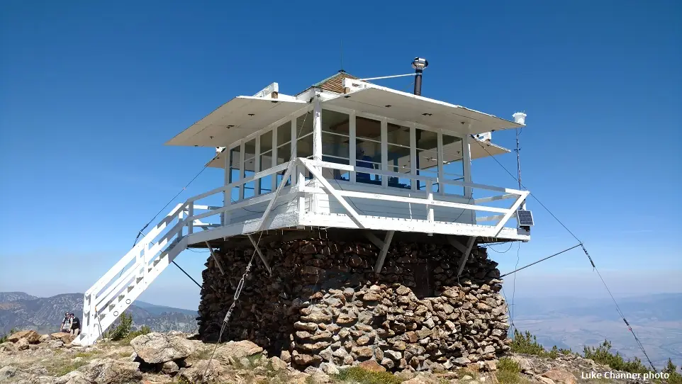
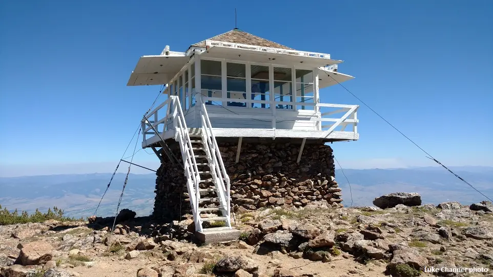
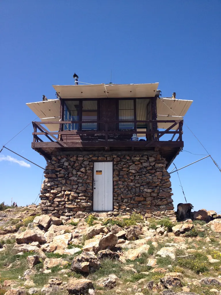

Photos keep their own rights and are shown with credit. Is one of these yours? You can ask for a different credit or for removal.
Where sources disagree
We show disagreements between sources instead of quietly picking one. If you know which is right, please tell us.
Sources disagree on the year it was built.
- NHLR: 1953
- firelookout.com -- Rex Kamstra's Forest Fire Lookout Page: 1931
Sources give different build years. Often one counts the first lookout on the site and another the structure there now.
Sources
- National Historic Lookout Register (NHLR) (opens another site) Gave us: name, location, county, elevation, what it is built of, register numbers, agency, ownership, dates, photos, links National Historic Lookout Register (nhlr.org) · All rights reserved (American Resources, Inc.); facts extracted only, no prose copied. · retrieved 4 Oct 2026
- Forest Fire Lookout Association (FFLA) - US lookout lists (opens another site) Gave us: type, status, register numbers, links Forest Fire Lookout Association (firelookout.org) · No licence stated; facts extracted only, no prose copied. · retrieved 8 Oct 2026
- firelookout.com -- Rex Kamstra's Forest Fire Lookout Page (opens another site) Gave us: design, height, staffing, photos, links firelookout.com · No licence stated on the site; facts only (coordinates, elevation, built/destroyed years, design, agency). Photos mirrored with the site's stated credit. · retrieved 4 Oct 2026
- Wikidata -- US fire lookout towers (Q748998 and subclasses) (opens another site) Gave us: register numbers, photos, links Wikidata · CC0 1.0 (Wikidata). Images keep their own Commons licence/credit. · retrieved 4 Oct 2026
- OpenStreetMap -- fire lookout structures (opens another site) Gave us: links © OpenStreetMap contributors · ODbL 1.0. (c) OpenStreetMap contributors. · retrieved 4 Oct 2026
- FOREST LOOKOUTS -- western US (Ron Kemnow's weebly sites) (opens another site) Gave us: links Ron Kemnow's Forest Lookouts sites (westlookouts, californialookouts, idaholookouts, montanalookouts, oregonlookouts and washingtonlookouts .weebly.com) · No licence stated; facts only (county, land manager, status word, coordinates where the page's own map widget gives them, township-range-section, height and design hints, links). The site's own newspaper quotes, citations and narrative are not reproduced. · retrieved 8 Oct 2026
- Firefinder research Gave us: summary, design, status, agency, access, visiting details, dates, links, fact-check Firefinder research (sources cited in the story footnotes) · Our own research notes; each fact cites its source in the lookout's story
More about this lookout elsewhere
- NHLR register entry US 47 (nhlr.org) (opens another site)
- Saint Mary Peak Lookout, National Register of Historic Places Registration Form (National Park Service) (opens another site)
- St. Mary lookout: A Brief History (Selway-Bitterroot Frank Church Foundation) (opens another site)
- FFLA Montana lookout list (firelookout.org) (opens another site)
- St. Mary Peak on firelookout.com (Rex Kamstra) (opens another site)
- St. Mary's Peak on Forest Lookouts, western US (Ron Kemnow) (opens another site)
- Wikidata item Q86928597 (opens another site)
- OpenStreetMap node 12093690489 (opens another site)
Firefinder takes facts (places, dates, numbers) from these sources and writes its own words. See all sources and licences.