Fire lookout · Jefferson County, Montana
Strawberry Lookout
Also known as Strawberry Cabin, Strawberry Butte
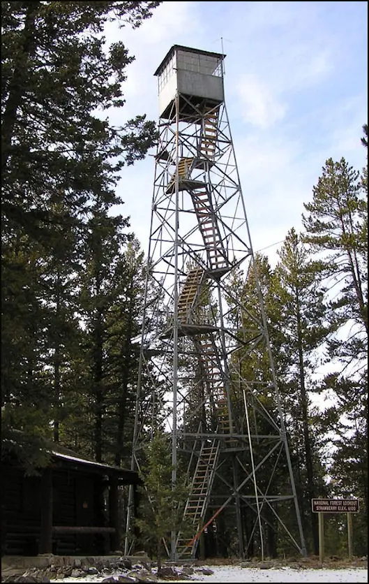
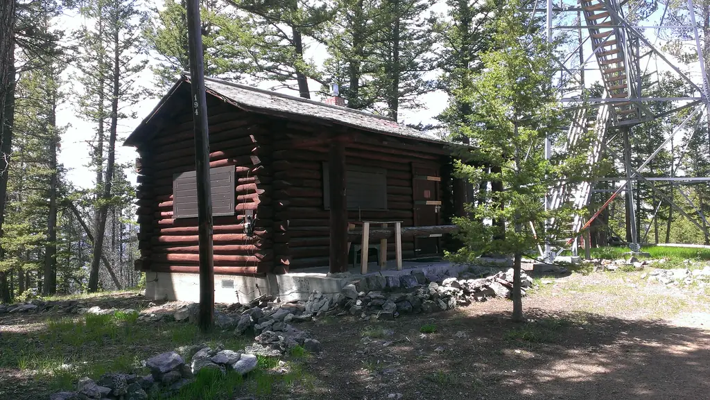
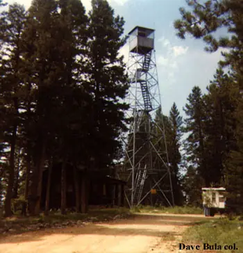
A 1941 steel Aermotor tower and log cabin on Strawberry Butte in the Elkhorns; the tower is closed to visitors while the cabin is rented year-round.
- Standing
- Rentable
- Restricted access
- Verified
Visit & stay
You can rent this lookout for overnight stays through recreation.gov.
Rules
- Clean the cabin before leaving
Overview Explore a magnificent recreation and wildlife resource at the doorstep of Montana's Capital City. From prairie to alpine, mayflies to mountain goats, and scenic driving to expert climbing routes -- the Elkhorns you will discover a diverse landscape! Built in 1941, Strawberry Cabin lies at the top of Strawberry Butte (6,100 feet) in the heart of the Elkhorn Mountains. The combination of lookout and log cabin are typical of this period. The cabin is an excellent example of a C-46 one room cabin plan, which was designed by William Fox. This cabin style is one of the standard building plans used for housing personnel working at intermediate stations and at lookouts. The C-46 design offers distinctive characteristics of ventral saddle notches and log ends finished in "chopper cut" style, which symbolizes rustic Forest Service log architecture of the second half of the 1930 and early 1940s. Recreation The area offers great access to the north end of the Elkhorn Mountains with numerous hiking trails and roads leading to the Elkhorn's historical resources. Popular hikes include Strawberry Creek, Casey Peak, and Willard Creek. When snow allows, cross country skiing or snowshoeing gives visitors an up-close look at concentrations of wintering elk. Facilities Strawberry Cabin is designed for up to four guests. One portion of the cabin has two twin beds, all with mattresses. The kitchen is equipped with a small table and two chairs, dishes, utensils, cookware, with a Coleman stove and lights. The cabin has a wood stove. The cabin is not wired for electricity. Fuel is not provided for the propane stove or lanterns, so guests should bring a couple of small propane cylinders, as well as backup lighting. An outhouse with vault toilet is located on-site. A picnic table and campfire ring offer comfortable outdoor dining. Firewood may available, but it is not guaranteed. No firewood is provided from June 1st - August 31. An axe and snow shovel are provided. There is no water on site, so guests must bring a sufficient supply for drinking, cooking and washing. Guests should bring their own sleeping bags, lanterns or flashlights, towels, dish soap, matches, and garbage bags. All garbage must be packed out, and guests are expected to clean the cabin before leaving. A fire lookout tower sits next to the cabin. This is one of the few metal lookout structures in the area and was built in the 1940s. The lookout is not open to the public and is no longer an active lookout. Natural Features The Elkhorn Mountains span both Broadwater and Jefferson counties, with the nearest city being Helena, Montana. The Elkhorns are surrounded by the Divide Mountains and Boulder Batholith to the west, and the Missouri and Boulder River valleys on the north, east, and south. The form of the Elkhorn Mountains is rounded and furrowed from extensive weathering. Drainages have carved steep gulches and canyons. The majority of the Elkhorns (north, west, southwest) is a part of a batholith. This geologic history has left the area rich in minerals. Evidence of glaciation is localized with boulder strewn areas of granitic rocks. The remaining approximate quarter (southwest) of the geographic area is underlain by sedimentary rock that lacks the same mineralization as the batholith but is rich in calcareous rock. The landforms are rugged, low mountains with hogback ridges and dry valleys. The sedimentary geologic area in the east is a gradient of foothill prairie and partially forested low mountains. Grassland is a major component. Limber pine and juniper woodland ebb and flow through this prairie landscape. The plant communities on the batholith portion are mostly forested with conifers. Aspen stands and water-loving plants take advantage of riparian areas and wet seeps. Parks, rich with grasses and forbs, are frequent at lower elevations and break up the forest in montane elevations. A large expanse of this area burned in 1988. The Elkhorns have been occupied by human inhabitants for thousands of years. However, prehistoric occupation is less evident than the more recent Euro-American settlement. After the discovery of valuable mineral deposits, mines and associated settlements sprang up in portions of the geographic area and remnant tools and infrastructure of the mining era are still evident. Strawberry Lookout, Eagle and Tizer Guard Stations are living reminders of Forest Service history in the area. Fire has historically has been a major influence to plant communities. A large forest fire in 1988 burned almost 50,000 acres of the mountain range, leaving carpets of seedlings growing into new lodgepole pine forests. Due to the rich wildlife habitats throughout the mountain range, the Elkhorns were designated a Wildlife Management Unit in 1986, the first of its kind in the nation. Collaborative groups composed of federal, state, and private land holders work toward habitat restoration and interpretation of the area's history. Nearby Attractions The Elkhorn Mountains are an island mountain range that provide open space, clean water and diverse animal and plant communities. The Elkhorns also provide livelihoods and places to hunt and recreate for the citizens in the surrounding communities and beyond. About 160,000 acres within the Elkhorn Mountains is managed by both the Helena and Beaverhead-Deerlodge National Forests as a Wildlife Management Unit, the only one of its kind in the entire National Forest System. In addition, there is another 75,000 acres of foothills that is managed by the Bureau of Land Management as an Area of Critical Environment Concern.
Book on recreation.gov (opens recreation.gov)
Rental details from recreation.gov, checked 12 Oct 2026. Rules, fees and seasons change, so confirm on the booking page before you go. Data source: ridb.recreation.gov
Access
Restricted access
Access is seasonal, gated or needs a permit. Check before you go. The tower is not open to the public. The cabin is rented to the public year-round, listed on Recreation.gov.
- Can you climb it?
- No
- Road to the top?
- No, you have to hike
- Trail
- Last mile of access is non-motorized only, 10/15 to 5/15 (Forest Service).
- Staffing
- Unknown
Facts
- Status
- Type
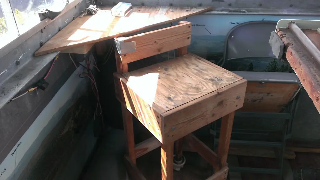
- Cab on a tower65-foot steel Aermotor tower with a 7x7 metal cab, above a one-story log cabin on the groundThe design: Aermotor
- Built of
- Steel
- Built
- 1941
- Height
- 65 ft (19.8 m)
- Elevation
- 4,989 ft (1,521 m)
- Agency
- U.S. Forest Service, Helena-Lewis and Clark National Forest
- Land
- Federal land
- Location
- Jefferson County, Montana
- Coordinates
- 46.47551, −111.91540 sources disagree
- Registers
- This entry
- VerifiedResearched, then checked independently. Updated 12 Oct 2026.
- Firefinder id
us-mt-strawberry
View from the cab
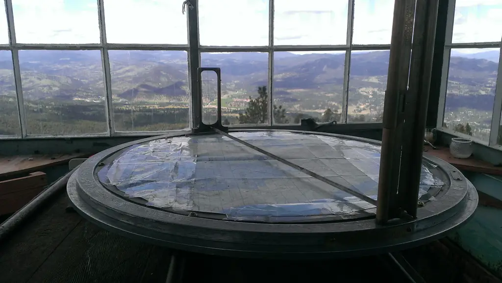
What you see from the cab: every ridge out to about 93 miles, the named peaks in sight, and other fire lookouts within view, worked out from terrain data in your browser.
Downloads about 3.6 MB of terrain data the first time.
Or see what it could see on the map: the ground in its line of sight.
History
Then and now
- 1941 BuiltErected in 1941 as a 65-foot steel Aermotor tower with a metal cab, with a one-story log cabin belowSources: nhlr.org, fs.usda.gov, firelookout.com
- No record between 1941 and 2005
- 2005 Added to the National Historic Lookout RegisterRegistered March 1, 2005 as US 631, MT 39Source: nhlr.org
- TodayStandingIt still stands, as far as our sources know.
Old maps of this spot
USGS topographic maps from the years a lookout stood may show it, often as a small symbol labelled “Lookout”. See the old topo maps around it on the Firefinder map, or find every scanned sheet of this spot on USGS TopoView (opens another site) (click the spot there to list them, with dates and downloads).
Story
Researched 8 Oct 2026, fact-checked.
Strawberry Butte tops out at 6,100 feet in the Elkhorn Mountains.1 A lookout went up on the summit in 1941: a 65-foot steel Aermotor tower with a small metal cab at the top, and a one-story log cabin on the ground below.2,3 The National Historic Lookout Register calls it the last structure of its type on the Helena National Forests, and lists it as US 631, MT 39, registered March 1, 2005.2 The cabin follows a C-46 plan, one of the standard designs used to house crews at intermediate stations and lookouts.1 The Forest Service says William Fox designed that plan.1
The sources I checked do not say when the tower last kept a fire watch, who staffed it, or whether it spotted any notable fires. Anyone with Forest Service station records would be the best place to fill that gap.
Recreation.gov now describes the tower as no longer an active lookout and not open to the public.4 The cabin has found a second life as a rental. The Forest Service says the cabin can be rented all year,1 and an undated Flickr photo post says the Helena Ranger District rents it out year-round for $50 a night.5 Firelookout.com instead calls it a wintertime recreation rental.3 Two sources point to year-round use, so this story follows them, but the disagreement is real.
Today the cabin is the part of the site a visitor can use. The Recreation.gov listing says there is no water on site, so guests bring their own.4 The Forest Service also says the last mile of access is non-motorized from October 15 to May 15.1 Because the tower itself is closed to visitors, the sensible plan is to book the cabin and leave the tower alone.4
- Strawberry Lookout Cabin, Helena-Lewis and Clark National Forest, U.S. Forest Service, https://www.fs.usda.gov/r01/helena-lewisclark/recreation/strawberry-lookout-cabin (accessed 2026-10-08). ↩
- Strawberry Lookout, National Historic Lookout Register, http://nhlr.org/lookouts/us/mt/strawberry-lookout/ (accessed 2026-10-08). ↩
- Strawberry Butte Fire Lookout Tower, firelookout.com, https://www.firelookout.com/mt/strawberrybutte.html (accessed 2026-10-08). ↩
- Strawberry Cabin, Helena-Lewis and Clark National Forest, Recreation.gov, https://www.recreation.gov/camping/campgrounds/272173 (accessed 2026-10-08). ↩
- Strawberry Butte Lookout Cabin, Montana, Flickr (Musgrove and the Pumi), https://www.flickr.com/photos/musguy/51479662217/ (accessed 2026-10-08). ↩
Photos
Photos keep their own rights and are shown with credit. Is one of these yours? You can ask for a different credit or for removal.
Where sources disagree
We show disagreements between sources instead of quietly picking one. If you know which is right, please tell us.
Sources disagree on the location by 3.8 km (2.4 mi).
- FFLA: 46.47551, −111.91540
- NHLR: 46.50865, −111.90250
They share a register number.
The map uses the position from FFLA.
Sources
- National Historic Lookout Register (NHLR) (opens another site) Gave us: name, county, elevation, register numbers, agency, dates, photos, links National Historic Lookout Register (nhlr.org) · All rights reserved (American Resources, Inc.); facts extracted only, no prose copied. · retrieved 4 Oct 2026
- Forest Fire Lookout Association (FFLA) - US lookout lists (opens another site) Gave us: location, type, status, register numbers, links Forest Fire Lookout Association (firelookout.org) · No licence stated; facts extracted only, no prose copied. · retrieved 8 Oct 2026
- Recreation Information Database (recreation.gov) (opens another site) Gave us: ownership, access, rental details, links Data source: ridb.recreation.gov · Public data from the US government · retrieved 12 Oct 2026
- Forest Fire Lookout Association: lookout rentals (opens another site) Gave us: rental details, links Forest Fire Lookout Association rentals list (firelookout.org) · No licence stated; facts extracted only (state, name, booking link, manager, closure note), no prose copied. The FFLA says it is not involved in managing any rental program. · retrieved 12 Oct 2026
- firelookout.com -- Rex Kamstra's Forest Fire Lookout Page (opens another site) Gave us: what it is built of, design, photos, links firelookout.com · No licence stated on the site; facts only (coordinates, elevation, built/destroyed years, design, agency). Photos mirrored with the site's stated credit. · retrieved 4 Oct 2026
- FOREST LOOKOUTS -- western US (Ron Kemnow's weebly sites) (opens another site) Gave us: height, links Ron Kemnow's Forest Lookouts sites (westlookouts, californialookouts, idaholookouts, montanalookouts, oregonlookouts and washingtonlookouts .weebly.com) · No licence stated; facts only (county, land manager, status word, coordinates where the page's own map widget gives them, township-range-section, height and design hints, links). The site's own newspaper quotes, citations and narrative are not reproduced. · retrieved 8 Oct 2026
- Firefinder research Gave us: summary, design, height, status, agency, access, visiting details, dates, links, fact-check Firefinder research (sources cited in the story footnotes) · Our own research notes; each fact cites its source in the lookout's story
More about this lookout elsewhere
- NHLR register entry US 631 (nhlr.org) (opens another site)
- NHLR register entry (nhlr.org) (opens another site)
- Recreation.gov listing (opens another site)
- Strawberry Lookout Cabin (U.S. Forest Service, Helena-Lewis and Clark National Forest) (opens another site)
- Strawberry Butte Lookout Cabin, Montana (Flickr (Musgrove and the Pumi)) (opens another site)
- FFLA Montana lookout list (firelookout.org) (opens another site)
- FFLA lookout rentals list (firelookout.org) (opens another site)
- Strawberry Butte on firelookout.com (Rex Kamstra) (opens another site)
- Strawberry Butte on Forest Lookouts, western US (Ron Kemnow) (opens another site)
Firefinder takes facts (places, dates, numbers) from these sources and writes its own words. See all sources and licences.