Fire lookout · Ravalli County, Montana
Sula Peak Lookout
Ravalli County, MT lookout on Sula Peak: first built 1929, destroyed by wildfire in 2000, rebuilt 2001 as a two-story cab; listed standing; no access information found.
- Standing
- Access unknown
- Verified
Visit & stay
Not rentable. As far as we know, this lookout cannot be booked for overnight stays.
Access
Access unknown
We do not know the access rules. Check with the land manager before you go.
- Can you climb it?
- Unknown
- Road to the top?
- Unknown
- Staffing
- Unknown
Facts
- Status
- Type
- Two-story buildingTwo-story octagonal cab (rebuilt 2001); earlier gable-roofed L-4 ground cab (1929) and 10-foot treated timber tower with L-4 cabThe design: L-4
- Built of
- WoodGoing by its design; no source says so in words.
- Built
- 1929
- Height
- 10 ft (3.0 m)
- Elevation
- 6,191 ft (1,887 m)
- Agency
- Bitterroot National Forest
- Land
- Federal land
- Location
- Ravalli County, Montana
- Coordinates
- 45.85999, −113.99960
- Registers
- Not on a lookout register
- This entry
- VerifiedResearched, then checked independently. Updated 9 Oct 2026.
- Firefinder id
us-mt-sula-peak
View from the cab
What you see from the cab: every ridge out to about 93 miles, the named peaks in sight, and other fire lookouts within view, worked out from terrain data in your browser.
Downloads about 4.2 MB of terrain data the first time.
Or see what it could see on the map: the ground in its line of sight.
History
Then and now
- 1929 BuiltEarly gable-roofed L-4 ground cab; Missoula newspaper reported the new lookout almost finished in June 1929Sources: firelookout.com, montanalookouts.weebly.com
- 1934 Altered10-foot treated timber tower with L-4 cab, per Forest Lookouts; firelookout.com dates a similar tower to 1957 with a question markSources: firelookout.com, montanalookouts.weebly.com
- No record between 1934 and 1959
- 1959 AlteredTower legs enclosed with concrete blocks; newspaper item of February 1960 says the base was finished that fallSources: firelookout.com, montanalookouts.weebly.com
- No record between 1959 and 1996
- 1996 Last staffedStaffed to 1996 per firelookout.com; staffed again in 1999Source: firelookout.com
- 2000 DestroyedDestroyed by a wildfire (firelookout.com: forest fire; Forest Lookouts: wildfire)Sources: firelookout.com, montanalookouts.weebly.com
- 2001 BuiltSource: firelookout.com -- Rex Kamstra's Forest Fire Lookout Page
- 2001 RebuiltNew two-story octagonal lookout (firelookout.com); one-of-a-kind design (Forest Lookouts)Sources: firelookout.com, montanalookouts.weebly.com
- TodayStandingIt still stands, as far as our sources know.
Old maps of this spot
USGS topographic maps from the years a lookout stood may show it, often as a small symbol labelled “Lookout”. See the old topo maps around it on the Firefinder map, or find every scanned sheet of this spot on USGS TopoView (opens another site) (click the spot there to list them, with dates and downloads).
Story
Researched 9 Oct 2026, fact-checked.
Sula Peak Lookout stands on Sula Peak in Ravalli County, Montana, about 14 miles southeast of Darby, at 6,191 feet.1 The Bitterroot National Forest manages it.1
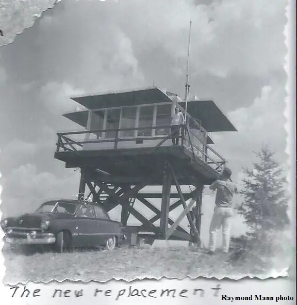
The first lookout went up in 1929.1,2 A Missoula newspaper reported in June 1929 that construction of the new lookout was nearly complete and that a Hamilton man would staff it over the summer.2 The early structure had a gable-roofed L-4 ground cab.1
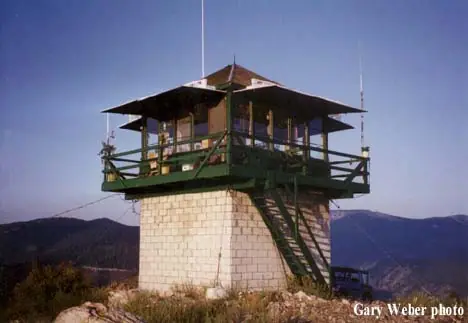
The Forest Lookouts page dates a 10-foot tower of treated timber, carrying an L-4 cab, to 1934.1,2 Firelookout.com dates a similar tower to 1957, with a question mark.1,2 The legs were enclosed in concrete blocks in 1959, and a February 1960 newspaper item says the base was finished that fall.1,2
Firelookout.com says staffing ran through 1996, with another season in 1999, and it lists known lookout personnel from 1931 to 2002.1
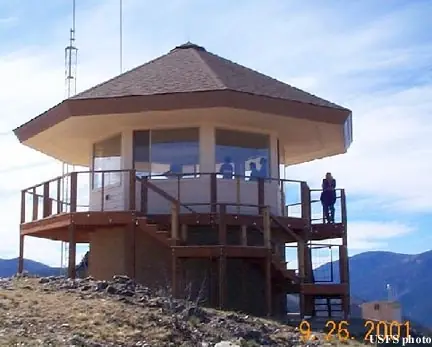
A wildfire destroyed the lookout in 2000.1,2 A new building went up in 2001.1,2 Firelookout.com describes it as a two-story octagonal lookout, and the Forest Lookouts page calls it a unique design.1,2
The Forest Fire Lookout Association lists Sula Peak as standing, with a two-story cab.3
We found no access information for the site. The Bitterroot's history page offers stays in historic lookouts but does not name Sula Peak.4 Anyone planning a visit should check with the Bitterroot National Forest first.
- Sula Peak Fire Lookout Tower, firelookout.com (Rex Kamstra), https://www.firelookout.com/mt/sulapeak.html (accessed 2026-10-09). ↩
- Sula Peak Lookout, Forest Lookouts (western US), Ron Kemnow, https://montanalookouts.weebly.com/sula-peak.html (accessed 2026-10-09). ↩
- Montana Lookouts, Forest Fire Lookout Association, https://firelookout.org/lookouts/us/mt/ (accessed 2026-10-09). ↩
- Discover History, Bitterroot National Forest, USDA Forest Service, https://www.fs.usda.gov/r01/bitterroot/recreation/discover-history (accessed 2026-10-09). ↩
Photos
Photos keep their own rights and are shown with credit. Is one of these yours? You can ask for a different credit or for removal.
Sources
- Forest Fire Lookout Association (FFLA) - US lookout lists (opens another site) Gave us: name, location, county, type, status, links Forest Fire Lookout Association (firelookout.org) · No licence stated; facts extracted only, no prose copied. · retrieved 8 Oct 2026
- firelookout.com -- Rex Kamstra's Forest Fire Lookout Page (opens another site) Gave us: elevation, what it is built of, design, agency, ownership, dates, photos, links firelookout.com · No licence stated on the site; facts only (coordinates, elevation, built/destroyed years, design, agency). Photos mirrored with the site's stated credit. · retrieved 4 Oct 2026
- OpenStreetMap -- fire lookout structures (opens another site) Gave us: links © OpenStreetMap contributors · ODbL 1.0. (c) OpenStreetMap contributors. · retrieved 4 Oct 2026
- FOREST LOOKOUTS -- western US (Ron Kemnow's weebly sites) (opens another site) Gave us: height, links Ron Kemnow's Forest Lookouts sites (westlookouts, californialookouts, idaholookouts, montanalookouts, oregonlookouts and washingtonlookouts .weebly.com) · No licence stated; facts only (county, land manager, status word, coordinates where the page's own map widget gives them, township-range-section, height and design hints, links). The site's own newspaper quotes, citations and narrative are not reproduced. · retrieved 8 Oct 2026
- Firefinder research Gave us: summary, design, status, agency, dates, links, fact-check Firefinder research (sources cited in the story footnotes) · Our own research notes; each fact cites its source in the lookout's story
More about this lookout elsewhere
- Discover History (Bitterroot National Forest, USDA Forest Service) (opens another site)
- FFLA Montana lookout list (firelookout.org) (opens another site)
- Sula Peak on firelookout.com (Rex Kamstra) (opens another site)
- Sula Peak on Forest Lookouts, western US (Ron Kemnow) (opens another site)
- OpenStreetMap way 624406520 (opens another site)
Firefinder takes facts (places, dates, numbers) from these sources and writes its own words. See all sources and licences.