Fire lookout · Henderson County, North Carolina
Bearwallow Mountain Lookout
1934 NC Forest Service steel tower on a Henderson County summit, staffed by Clyde Curtis from 1957 until the 1990s; trail reopened 2025 from one side only after Helene.
- Standing
- Restricted access
- Verified
Visit & stay
Not rentable. As far as we know, this lookout cannot be booked for overnight stays.
Access
Restricted access
Access is seasonal, gated or needs a permit. Check before you go. The summit trail reopened in July 2025 only from the Edneyville side, after Hurricane Helene closures. Access to the tower itself is not confirmed.
- Can you climb it?
- Unknown
- Road to the top?
- Unknown
- Trail
- Trail reached from the Edneyville side. Routes through Gerton, including Highway 74-A and the lower Bearwallow Mountain Road, were still closed at the July 2025 reopening.
- Staffing
- Not staffed (as of 1990s)
Facts
- Status
- Type
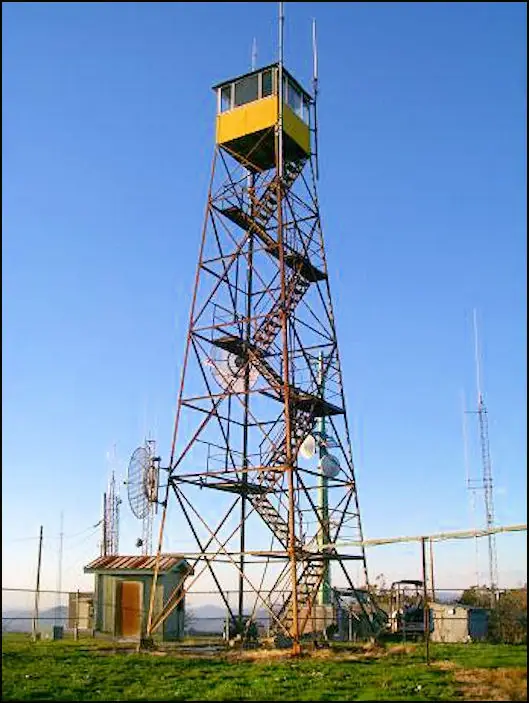
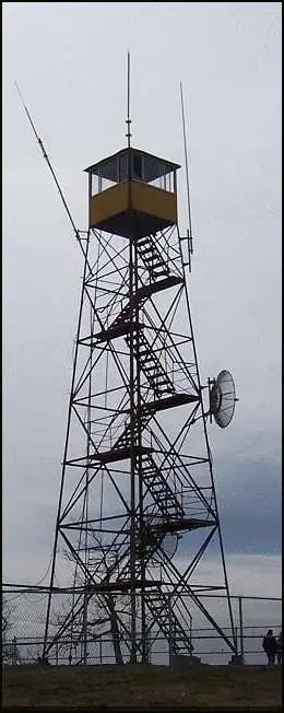
- Cab on a tower47-foot Aermotor tower with a 7 by 7 ft metal cabThe design: Aermotor
- Built of
- SteelGoing by its design; no source says so in words.
- Built
- 1934
- Height
- 47 ft (14.3 m)
- Elevation
- 4,232 ft (1,290 m)
- Agency
- NC Division of Forest Resources
- Land
- Unknown
- Location
- Henderson County, North Carolina
- Coordinates
- 35.46101, −82.35734
- Registers
- NHLR US 718 · NC 12
- NGS FB 2908
- This entry
- VerifiedResearched, then checked independently. Updated 8 Oct 2026.
- Firefinder id
us-nc-bearwallow-mountain
View from the cab
What you see from the cab: every ridge out to about 93 miles, the named peaks in sight, and other fire lookouts within view, worked out from terrain data in your browser.
Downloads about 3.5 MB of terrain data the first time.
Or see what it could see on the map: the ground in its line of sight.
History
Then and now
- 1934 BuiltNC Forest Service constructed the 47-foot steel tower; a state report of the 1932-34 biennium names it as the only tower bought with state budget money.Sources: nhlr.org, easternuslookouts.weebly.com
- No record between 1934 and 1957
- 1957 StaffedClyde Curtis began staffing the tower; he later lived on the summit year-round.Source: conservingcarolina.org
- No record between 1957 and 1992
- 1992 EventCurtis lived on the summit until 1992; the tower was decommissioned a few years later.Source: conservingcarolina.org
- No record between 1992 and 2008
- 2008 Added to the National Historic Lookout RegisterRegistered on the National Historic Lookout Register, April 2, 2008.Source: nhlr.org
- 2011 EventRegister projected restoration for 2011 to 2012. No source read confirms the work was done.Source: nhlr.org
- 2024 ClosedSummit trail closed after Hurricane Helene damage in September 2024.Source: enlacelatinonc.org
- 2025 EventTrail reopened in July 2025, from the Edneyville side only.Source: enlacelatinonc.org
- TodayStandingIt still stands, as far as our sources know.
Old maps of this spot
USGS topographic maps from the years a lookout stood may show it, often as a small symbol labelled “Lookout”. See the old topo maps around it on the Firefinder map, or find every scanned sheet of this spot on USGS TopoView (opens another site) (click the spot there to list them, with dates and downloads).
Story
Researched 8 Oct 2026, fact-checked.
The North Carolina Forest Service put up the Bearwallow Mountain tower in 1934.1 The tower is 47 feet tall, an Aermotor design topped by a 7-by-7-foot metal cab, and it sits on the Eastern Continental Divide in Henderson County.1 A state report from those years says the steel tower on Bear Wallow Mountain was the only tower bought with state budget money in that period.2
Clyde Curtis began staffing the tower in 1957.3 He and his wife made the summit their year-round home, starting in a two-room log cabin and later moving to a small frame house.3 Curtis remembered days with as many as 30 or 40 fires, and a top wind reading of 103 mph before the anemometer blew away.3
Curtis lived on the summit until 1992, and the tower was taken out of service a few years after that.3 Most fire detection now happens by aircraft and by calls from the public.3 The register projected restoration work for 2011 to 2012.1 No later source confirms that the work was finished.
Hurricane Helene closed the Bearwallow Mountain Trail in September 2024.4 The trail reopened in July 2025, but only from the Edneyville side, and the roads through Gerton stayed closed.4 The trail exists because of an agreement with the Lyda family, who own the land.4 Conserving Carolina adds that the Hickory Nut Gorge region is still very much in hurricane recovery.4
- Bearwallow Mountain Lookout, National Historic Lookout Register, http://nhlr.org/lookouts/us/nc/bearwallow-mountain-lookout/ (accessed 2026-10-08). ↩
- Bearwallow Mountain, Forest Lookouts (Eastern US Lookouts), https://easternuslookouts.weebly.com/bearwallow-mountain.html (accessed 2026-10-08). ↩
- The History of Bearwallow Mountain, Conserving Carolina, https://conservingcarolina.org/the-history-of-bearwallow-mountain/ (accessed 2026-10-08). ↩
- Bearwallow Mountain reopens after nine months of closure, Enlace Latino NC, https://enlacelatinonc.org/en/Bearwallow-Mountain-reopens-after-nine-months-of-closure-due-to-Helene/ (accessed 2026-10-08). ↩
Photos
Photos keep their own rights and are shown with credit. Is one of these yours? You can ask for a different credit or for removal.
Sources
- National Historic Lookout Register (NHLR) (opens another site) Gave us: name, location, county, elevation, type, what it is built of, status, register numbers, agency, dates, photos, links National Historic Lookout Register (nhlr.org) · All rights reserved (American Resources, Inc.); facts extracted only, no prose copied. · retrieved 4 Oct 2026
- tnlandforms.us fire lookout towers (Tom Dunigan) -- GA, NC, TN (opens another site) Gave us: register numbers, links tnlandforms.us (Tom Dunigan) · No licence stated; facts only (coordinates, county, elevation, NGS/GFC/BLL register cross-references, status where given). · retrieved 4 Oct 2026
- FOREST LOOKOUTS -- eastern US (easternuslookouts.weebly.com) (opens another site) Gave us: height, links easternuslookouts.weebly.com · No licence stated; facts only (county, coordinates where the page's own map widget gives them, status, height, design hints, register links). The site's own historical quotes, newspaper citations and narrative are not reproduced. · retrieved 8 Oct 2026
- Forest Fire Lookout Association chapter reports (opens another site) Gave us: dates, links Forest Fire Lookout Association, chapter and restoration-grant reports (firelookout.org) · No licence stated; facts only (dates, names, the kind of work done). Every note is our own wording and every event links to the FFLA report it comes from. Positions are copied from the NHLR, FFLOS and FFLA records. · retrieved 8 Oct 2026
- OpenStreetMap -- fire lookout structures (opens another site) Gave us: links © OpenStreetMap contributors · ODbL 1.0. (c) OpenStreetMap contributors. · retrieved 4 Oct 2026
- Firefinder research Gave us: summary, design, height, status, agency, access, staffing, visiting details, dates, links, fact-check Firefinder research (sources cited in the story footnotes) · Our own research notes; each fact cites its source in the lookout's story
More about this lookout elsewhere
- NHLR register entry US 718 (nhlr.org) (opens another site)
- NHLR register entry (nhlr.org) (opens another site)
- The History of Bearwallow Mountain (Conserving Carolina) (opens another site)
- Bearwallow Mountain reopens after nine months of closure (Enlace Latino NC) (opens another site)
- Forest Fire Lookout Association chapter reports: work on Bearwallow Mountain Lookout (opens another site)
- Bearwallow Mountain (tnlandforms.us (Tom Dunigan)) (opens another site)
- Bearwallow Mountain (easternuslookouts.weebly.com) (opens another site)
- OpenStreetMap node 4802211878 (opens another site)
Firefinder takes facts (places, dates, numbers) from these sources and writes its own words. See all sources and licences.